
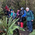
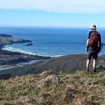
 21/01/2026. Leith Saddle/Swampy/Burns Track. Grade 4. Trampers. Leaders: Pam Cocks and Neil Hodgkin.
Another enjoyable tramp in the Silver Peaks
Category: Trampers
Hoopers Inlet – Rutherfords – Stewarts – Lime Kilns – Nyhon track
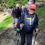
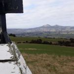
 14/01/2026. Hoopers Inlet, Rutherfords – Stewarts, Lime Kilns, Nyhon Track. Grade 3. Trampers. Leaders: Spen Walker, Jane Bruce, Sandy Webb
The Mosgiel contingent had an 8.30 am start and arrived at Shore St before 9 am, ably coordinated by Neil Hodgkin.
Continue reading “Hoopers Inlet – Rutherfords – Stewarts – Lime Kilns – Nyhon track”
Millenium Track from Taieri Mouth to Lookout
 03/12/2025. Millenium Track from Taieri Mouth to Lookout. Grade 3. Trampers. Leaders: Sandy Webb and Alison Evans.
The weather gods were not on our side, so the planned Silver Peaks tramp was reluctantly shelved for another day. Continue reading “Millenium Track from Taieri Mouth to Lookout”
Highcliff, Paradise and Buskin Tracks
 26/11/2025. Highcliff, Paradise and Buskin Tracks. Grade 4. Trampers. Leaders: Clare Banks and Carol Thurlow
23 trampers left the entrance to the Highcliff Track carpark at 9.35am, knowing very hot and blustery conditions were forecasted for the day. Continue reading “Highcliff, Paradise and Buskin Tracks”
Hermits Cave via Pulpit Rock.
 19/11/2025. Hermits Cave via Pulpit Rock. Grade 5. Trampers. Leaders: Graham Thurlow and John Gardiner.
The tramp to Pulpit Rock is a well known one to most of us, but today’s tramp there came with a twist.
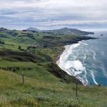
Three Peaks, Escarpment, Cloud Forest Loop
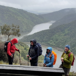
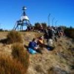
 12/11/2025. Three Peaks, Escarpment, Cloud Forest Loop. Grade 3.5. Trampers. Leaders: Sarah McCormack and Karen McInnis.
22 trampers set off from Sullivans dam in blustery conditions but it was sunny and not cold.
Continue reading “Three Peaks, Escarpment, Cloud Forest Loop”
Outram Glen and Beyond
 22/10/2025. Outram Glen and Beyond. Grade 2. Trampers. Leaders: Jill Reid and Heather Kirk.
We had 20 happy trampers arrive at Outram for our walk on Wednesday.
South Waikouaiti River Track
 15/10/2025. South Waikouaiti River Track. Grade 4. Trampers Leaders: Ross Davies, Neil Hodgkin.
Wednesday’s tramp was an alphabet.
Daphne/Big Stone Roads, Brighton
 08/10/2025. Daphne/Big Stone Roads, Brighton. Grade 3. Trampers. Leaders: Sylvie Watt & Lyn Keene
On a perfect day 22 trampers set off. 2 cars were left at the bottom off Big Stone Rd.
Government Track Circuit
 24/09/2025. Government Track Circuit. Grade 4.5. Trampers. Leaders: John Gardiner and Carolyn Pridham
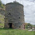
The Government Track was originally built in 1860 to provide horse and dray access to the Waipori Goldfields.
Nicols Creek, Moon Track, Swampy Ridge, Pineapple and Shortcut Tracks
 10/09/2025. Nicols Creek, Moon Track, Swampy Ridge, Pineapple and Shortcut Tracks. Grade 4. Trampers. Leaders: Gwenda Farqharson, Lyn Keene.
20 Trampers met at Leith Valley Road, our tramp followed the Nicol’s Falls track. Continue reading “Nicols Creek, Moon Track, Swampy Ridge, Pineapple and Shortcut Tracks”
Peggy’s Hill from Macandrew Bay
 27/08/2025. Peggy’s Hill from Macandrew Bay. Grade 4. Trampers. Leaders: Graeme Souter and Gwenda Farqharson.
Peggy – who on earth was Peggy? Read on ….
Continue reading “Peggy’s Hill from Macandrew Bay”
Nichol’s Farm (Michelle’s Farm)
 20/08/2025. Nichol’s Farm (Michelle’s Farm) . Grade 4. Trampers. Leaders: Gail Williams, Lynley McArley.
After parking under the Outram Bridge, nineteen trampers made their way alongside the Northern aspect of the Taieri river on the flat and then began an ascent up into the hills along a farm track. Continue reading “Nichol’s Farm (Michelle’s Farm)”
Bethunes Gully to Mt Cargill
 13/08/2025. Bethunes Gully to Mt Cargill. Grade 3. Trampers. Leaders: Esther Willis, Graeme Souter.
Twenty two people set off- and returned- on a stunningly beautiful day. Destination, Mountain Cargill. Continue reading “Bethunes Gully to Mt Cargill”
Purakaunui/ Mopanui
 30/07/2025. Purakaunui/ Mopanui. Grade 4. Trampers. Leaders: Carol and Clare.
After a very foggy departure for some from Mosgiel, 16 trampers gathered at the top of Osborne to head up Mopanui Hill at 10.30am, in overcast but still conditions. Continue reading “Purakaunui/ Mopanui”