
 15/07/2026. Chalkies. Grade 4. Trampers. Leaders: Sarah McCormack, Heather Casey.
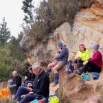
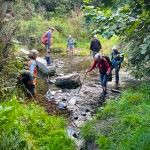
Seventeen trampers set out on a dull but fine morning. Rain had been forecast, but apart from
a few drops, we enjoyed a dry tramp—at least from above. Continue reading “Chalkies Circuit, Powder Hill”
Category: Trampers
Grahams Bush/Quarry Track
 24/06/2026. Graham’s Bush/Mt Cargill Rd Quarry Track. Grade 4. Trampers. Leaders: John Gardiner & Alison Evans.
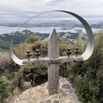
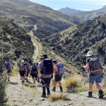
An overcast, but dry morning, saw 19 keen trampers convene at the end of Hall Rd, then set off at 10.15 am through Graham’s Bush for Mt Cutten and the nearby Len Lye memorial.
Boulder Beach
 10/06/2026. Boulder Beach. Grade 3. Trampers. . Leaders: Pam Cocks and Gail Williams.
Twenty trampers met at the top of McMeeking road on a stunning Dunedin day, sunny with little wind. Continue reading “Boulder Beach”
Pineapple Track / Nicols Creek
 27/05/2026. Pineapple Track / Nicols Creek. Grade 4. Trampers. Leaders: Karen McInnnes and Sarah McCormack
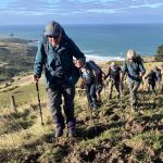
17 mud loving trampers met at Tanner Road on a brisk Dunedin morning for our “workout”.
Continue reading “Pineapple Track / Nicols Creek”
Signal Hill from Ravensbourne
 29/04/2026. Signal Hill from Ravenbourne. Grade 4. Trampers. Leaders: Sandy Webb & Gail Williams.
23 trampers met at Rimu St and began the trek uphill via the Signal Hill and Telecom tracks.
Craiglowan Falls
 22/04/2026. Craiglowan Falls. Grade 4. Trampers. Leaders: Katrina McKenzie and Julie McKenzie.
After much pondering and phone calls to the club kaumatua we decided to go ahead with the walk despite more rain since the recce. Continue reading “Craiglowan Falls”
Kaik-Otakou
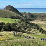 15/04/2026. Kaik-Otakou. Grade 3. Trampers. Leaders: Sylvia Watts and Carolyn Pridham.
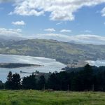
On a super lovely day we headed down the Otago Peninsula to Otakou all stopping near the bus stop.
Taieri View Farm Tramp
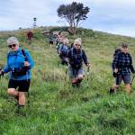 08/04/2026. Taieri View Farm Tramp. Grade 3. Trampers. Leaders: Jill Reid and Sue Johnstone.
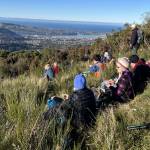
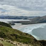
After parking on Taioma Rd, our group of 20 trampers set out on an overcast morning which offered good district views.
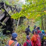
Whare Flat – Racemans – North Coal Creek – Steve Amies Return
 25/03/2026. Whare Flat-Racemans-North Coal Creek-Steve Amies-Return. Grade 4. Trampers. Leaders: Robyn and Martin Hickley.
Nineteen trampers left the Whare Flat carpark under low cloud and mild temperatures. Continue reading “Whare Flat – Racemans – North Coal Creek – Steve Amies Return”
Bannockburn Camp 2026 (Day 3) – Bendigo Kanuka Loop Track
 09/03/2026 to 13/03/2026. Bannockburn Camp 2026 (Day 3) – Bendigo Kanuka Loop Track. Trampers Leaders: Rod Ward and Pam Cocks
Continue reading “Bannockburn Camp 2026 (Day 3) – Bendigo Kanuka Loop Track”
Doctors Point/Mopanui
 18/03/2026. Doctors Point/Mopanui. Grade 4. Trampers. Leaders: Graeme Souter and John Barrett.
Ba Humbug what’s a bit of rain when it’s tramping day and the Met Service says it’s going to clear?
Jubilee Hut from Silver Peaks Station
 25/02/2026. Jubilee Hut from Silver Peaks Station. Grade 5. Trampers. Leaders: Martin and Robyn Hickley.
Fifteen trampers set off earlier than usual because of a road closure between Outram Glen and Hindon. Continue reading “Jubilee Hut from Silver Peaks Station”
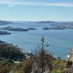
Sandymount
 18/02/2026. Sandymount. Grade 3. Trampers. Leaders: John Gardiner & Graeme Souter.
With 93.6mm of rain on Tuesday, the prospects for Wednesday’s tramp weren’t great. However, after a cool and overcast start, the weather improved to comfortable, if at times slightly windy, conditions.
Jim Freeman, McQuilkans, Swampy Summit Track Rolleston Road Circuit
 11/02/2026. Jim Freeman McQuilkans Swampy Summit Track Rolleston Road Circuit. Grade 4. Trampers. Leaders: Phil Morris and Carolyn Pridham.
The Trampers travelled to Rolleston Road and parked at the locked gate on Rolleston Road.
Continue reading “Jim Freeman, McQuilkans, Swampy Summit Track Rolleston Road Circuit”
Roulston Farm
 28/01/2026. Roulston Farm. Grade 4. Leaders: Jill Reid, Lenore Armstrong.
Such a lovely fun filled day held by all. We started off with what we thought was 16 walkers, but after morning tea and re counting we had 15, and no we hadn’t lost anyone on the way! Continue reading “Roulston Farm”