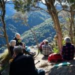
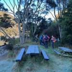
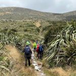
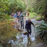
 23/7/2025. Steve Aimes / North Coal Creek. Grade 4. Trampers. Leaders: Graham Thurlow and Neil Hodgkin.
On a crisp frosty morning 16 hardy trampers met in the frost at the Silverstream carpark…….
Taieri Recreational Tramping Club
Mid-week recreational and social walking group based in Mosgiel NZ

23/7/2025. Steve Aimes / North Coal Creek. Grade 4. Trampers. Leaders: Graham Thurlow and Neil Hodgkin.
On a crisp frosty morning 16 hardy trampers met in the frost at the Silverstream carpark…….
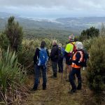
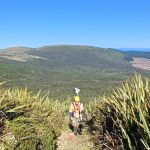
 16/07/2025. Heyward Point from Aramoana. Grade 3.5. Trampers . Leaders: Karen McInnes, Gail Williams.
Twenty-three well rugged up trampers left cars at the bottom of the start of the Heyward Track and began the steep ascent to the top.
 09/07/2025. Peak Bagging from Cedar Farm. Grade 4. Trampers. Leaders: Sarah McCormack and Ross Davies.
It wasn’t the best of days; it wasn’t the worse of days. It was a day you might stay home in the warm, or it was a day you might go out peak bagging.
 25/06/2025. Grahams Bush, Organ Pipes, Buttars Peak. Grade 4. Trampers. Leaders: Phil Morris, Rod Ward.
We left 9.30 from PJ Park travelling to Sawyers Bay, to the end of Hall Road, meeting up with townies with really good numbers (26) at 10.10am.
Continue reading “Grahams Bush Track, Organ Pipes, Buttars Peak”
 18/06/2025. Millennium Track return from Henley. Grade 3.5. Trampers. Leaders: Sarah McCormack and Heather Kirk
A very frosty morning greeted all 18 of us trampers as we arrived at the Henley end of the Millennium track.
 28/05/2025. Careys Creek / Black Gully. Grade 4.5. Trampers. Leaders: Ross and Wyn Davie.
All twelve of us met up in Waitati by the Turdis, after the Townie contingent had stashed a car at Evansdale Glen for shuttling at the end of the trip. Continue reading “Careys Creek / Black Gully”
 21/05/2025. Craiglowan Falls. Grade 4. Trampers. Leaders: Katrina McKenzie & Julie MacKenzie.
17 trampers set out on a lovely Wednesday morning.
 14/05/2025. Pulpit Rock. Grade 4. Trampers. Leaders: Graham Thurlow, Lyn Keene.
On a beautifully sunny and calm day 15 trampers tackle a well-known, and thanks to the Green Hut Group, well maintained track. Continue reading “Pulpit Rock”
 30/04/2025. Pipeline, Burns, Swampy Summit, Rustlers Ridge Circuit. Grade 4. Trampers. Leaders: Carolyn Pridham and Esther Willis.
Seven (7) intrepid trampers set off from the Leith Saddle car park looking forward to ‘tiptoeing’ through bogs on a mud-filled adventure.
Continue reading “Pipeline, Burns, Swampy Summit, Rustlers Ridge Circuit”
 23/04/2025. West of Flagstaff via Spiers Track. Grade 4.5. Trampers. Leaders: Pam Cocks & Karen McInnes.
Heavy rain overnight put the Tramp Grade up to 4.5 where John and his Harem of 8 departed at 9.20 from Spiers road. A short walk up a shingle road over a style took us onto Spiers Track. We followed the 4 wheel drive track uphill over scruffy farmland for 30 mins before entering Spiers Track proper.
 16/04/2025. Leisman Falls, Powder Hill, Chalkies Circuit. Grade 4. Trampers. Leaders: Katrina McKenzie, Julie MacKenzie
It was a lovely morning after not so great forecasts. 16 trampers set out from Whare Flat car park for a 10 minute walk back up the road to the start of the track. Continue reading “Leisman Falls, Powder Hill, Chalkies Circuit”
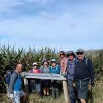
 11/04/2025 Flax/ Track Clearing. Trampers. Leader: Phil Keene.
The famous 5 emerged to take on the challenge ‘up on Swampy’ and were underway on Upper Swinespur by just after 9am; a stunning drive up through Rollinsons Rd – no haze, just a big panorama.
 09/04/2025. Trotters Gorge. Grade 3. Trampers. Leaders: Neil Hodgkin and Sarah McCormack.
Two cars from Mosgiel and another one from Dunedin arrived at Trotter’s Gorge Scenic Reserve on a clear windless day.
 26/03/2025. Flax / Track Clearing. Trampers. Leader: Phil Keene.
A splendid day attracted 8 splendid machinists/trimmers/hackers/rakers or…….and we headed up on to Swampy.
 19/03/2025. Yellow Ridge via Walkers Road, River Track/out via Tunnel Track. Grade 5. Trampers. Leader: Ross Davies.
Three of us showed up for an adventure in the South Waikouaiti River. Continue reading “Yellow Ridge via Walkers Road, River Track/out via Tunnel Track”