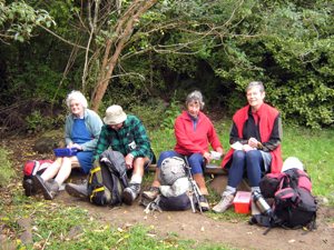
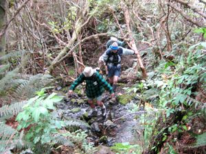
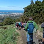
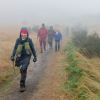
 27/05/2026. Pineapple Track / Nicols Creek. Grade 4. Trampers. Leaders: Karen McInnnes and Sarah McCormack
17 mud loving trampers met at Tanner Road on a brisk Dunedin morning for our “workout”.
Continue reading “Pineapple Track / Nicols Creek”
Taieri Recreational Tramping Club
Mid-week recreational and social walking group based in Mosgiel NZ

27/05/2026. Pineapple Track / Nicols Creek. Grade 4. Trampers. Leaders: Karen McInnnes and Sarah McCormack
17 mud loving trampers met at Tanner Road on a brisk Dunedin morning for our “workout”.
Continue reading “Pineapple Track / Nicols Creek”
 15/10/2025. Pineapple Track/ Ross Creek. Grade 3. Hikers. Leaders: Wendy Langley, Val Cayford.
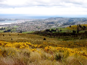
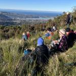
What a magnificent hike we had today. The weather, company, bush walks and views of Dunedin were all top notch.
 10/09/2025. Nicols Creek, Moon Track, Swampy Ridge, Pineapple and Shortcut Tracks. Grade 4. Trampers. Leaders: Gwenda Farqharson, Lyn Keene.
20 Trampers met at Leith Valley Road, our tramp followed the Nicol’s Falls track. Continue reading “Nicols Creek, Moon Track, Swampy Ridge, Pineapple and Shortcut Tracks”
 26/06/2024. Nicols Creek, Pineapple Track. Trampers. Grade 4. Leaders: Wyn and Ross Davies.
The weather forecasts were not very encouraging. Nevertheless, 12 courageous trampers arrived at the meeting point at Booth Road Continue reading “Nicols Creek, Moon Track, Pepper Tree Track, Pineapple Track”
This page of club tramps and hikes in the Dunedin Central City area groups together trips from the Bull Ring (Flagstaff / Whare Flat Road) and incorporates the Flagstaff Walkway, Pineapple Track and Ben Rudd shelter. (map)
Road distances from Mosgiel carpark.
Location: 13.3 km from car-park.
TRTC Grading Information – trips incorporating these tracks are generally given a TRTC grading of about 3. This is indicative only, as trips can be allocated a higher or lesser grading depending on the route taken. For more detailed analysis refer to Grading Information.
Dunedin’s Hills’ History for background information.
Pineapple Track for background information.
Pineapple and Flagstaff walk for background information.
Flagstaff Name for its origin.
Ben Rudd Article for background information.
Access to the Bull Ring (and the Pineapple Track) on Flagstaff is off the Flagstaff-Whare Flat Road. This can be accessed off Three Mile Hill Road by turning left at the top of Three Mile Hill and continuing approx. 5 minutes to the Bull Ring carpark.
10/06/2026. Flagstaff. Grade 3. Hikers. Leaders: Phil Keene and Barbara Shackell.
23/10/2024. Flagstaff, Bull Ring. Grade 2.5. Hikers. Leaders: Theresa White, Julie MacKenzie.
Bull Ring, Flagstaff Walkway/ Pineapple Track. 2018 – 2008 (8 trips, 3 with reports and photos, 2 with photos only, 3 with no reports or photos)
Bull Ring, Ben Rudd. 2024 – 1995 (13 trips, 3 with reports and photos, 10 with no reports)
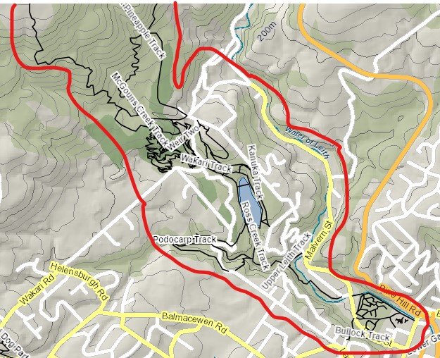
This grouping of Club tramps and hikes covers trips involving Woodhaugh, Leith Valley up to Islay Street, Pineapple Track up to Flagstaff (Skyline) Track, Davies Track, McGouns Track, Wakari Rd Bike Tracks, Ross Creek Reserve, Cannington Road and Prospect Road.
Road distances from Mosgiel carpark.
TRTC Grading Information – trips incorporating these tracks are generally given a TRTC grading of 4. This is indicative only, as trips can be allocated a higher or lesser grading depending on the route taken. For more detailed analysis refer to Grading Information.
Dunedin’s Water Supply.
Pineapple Track: Information.
Pineapple and Flagstaff Walk.St. E
There are multiple entrances to Ross Creek
(1) Leith Valley – take SH1 north and turn left onto Duke St. Continue on Duke St which merges into Malvern St, past the Woodhaugh Gardens, over the bridge spanning the Leith River and turn immediately into Woodhaugh St. Ross Creek entrance is behind the NZMCA Camping Ground.
15/10/2025. Pineapple Track/ Ross Creek. Hikers. Grade 3. Leaders: Wendy Langley, Val Cayford.
01/10/2025. Ross Creek Reservoir. Combined. Grade 3. Leaders: Yan Campbell, Graeme Souter, Jenni Wright, Wendy Langley.
28/08/2024. Ross Creek and Davies Track. Trampers. Grade 4 Leaders: Ross Davies and Sarah McCormack.
Ross Creek and Environs (1990 – 2024, 34 trips including 15 with reports).
Booth Road, McGouns, Pineapple Track, Ben Rudd (1990 – 2023, 9 trips including 4 reports).
Spiers Road, Davies, McGouns Creek Extension (2009 – 2023).
Bull Ring, Swampy, Nicols, Pt Pineapple, Davies, return (1989 – 2020, 4 trips, 2 with reports including 16/09/2009 Davies Track)
Davies Track, Ben Rudd (1995 – 2014, 5 trips with 1 report – see also
Warburton Track ?aka. Davies Track?).
Big (Bivvy) Rock, Pineapple, Davies, Firebreak (1991 – 2012, 3 trips with 2 reports).
Nicols Creek, Swampy Saddle, Davies Track (2001 – 2011, 3 trips with 2 reports).
Bull Ring, Flagstaff Walkway, Pineapple, McGoun, Davies, return Nicols Creek, Swampy Saddle, Davies Track (2010, 1 trip with report).
Davies Track, Jim Freeman (2000, 1 trip with no report). Continue reading “Ross Creek, Lower Leith Valley, Wakari Rd Bike Park, McGouns, Pineapple and Davies Tracks – Information and Trips Library”
This page of club tramps and hikes to the Leith Valley area and groups together trips to Nicols Creek (map) incorporating the Pineapple Track, Nicols Falls, Moon Track and other tracks on Swampy.
Road distances from Mosgiel carpark.
TRTC Grading Information – trips incorporating these tracks are generally given a TRTC grading of 4. This is indicative only, as trips can be allocated a higher or lesser grading depending on the route taken. For more detailed analysis refer to Grading Information.
DCC land. Nicols Creek circuit maintained by Green Hut Track Group.
David Nicol was an early settler and dairy farmer. He reputedly bought land here in the hope that the railway line would be routed north through Leith Valley.
Antony Hamel’s YouTube video showing his exploration of the 5 falls of Nicols Creek.
Neighbours at War Background and photos to the Finnerty Family and their house site on the Moon Track by Nicols Creek.
Swampy ridge track background information.
Pineapple Track for background information.
Pineapple and Flagstaff walk for background information.
Nicols Creek Glow-worms
Take SH1 north and turn left onto Duke St. Continue on Duke St into Malvern St and onto Leith Valley Road. Continue to the sign indicating the Nicol’s Creek Track and mountain bike track. There is limited parking the track entrance. Parking therefore is often best in Booth Road (left off Malvern St) and then take Islay St (off Booth Road) back to Malvern and Leith Valley Roads to the track.
Links to tramps and hikes to the same area:
27/05/2026. Pineapple Track / Nicols Creek. Grade 4. Trampers. Leaders: Karen McInnnes and Sarah McCormack
10/09/2025. Nicols Creek, Moon Track, Swampy Ridge, Pineapple and Shortcut Tracks. Grade 4. Trampers. Leaders: Gwenda Farqharson, Lyn Keene.
26/06/2024. Nicols Creek, Pineapple Track. Grade 4. Trampers. Leaders: Wyn and Ross Davies.
Nicols Creek, Swampy, Pineapple Track, Moon Track, Booth Road 2023 – 1989 (27 trips, 9 with reports and photos, 1 with report only, 17 with no reports or photos)
Bull Ring, Swampy, Nicols, Pineapple Point, Davies, return 2020 – 1989 (4 trips, 2 with reports and photos,
Nicols Creek Bridge, Morrisons Burn, Poleline Road, Swampy, Nicols or Pineapple 2016 – 2006 (6 trips, 2 with reports and photos, 1 with photos only, 3 with no reports or photos)
Nicols Creek, Swampy Saddle, Davies Track 2011 – 2001 (3 trips, 1 with report and photos, 2 with reports only)
Moon, McQuilkan, Possum Hunters, Jim Freeman, Pineapple, Nicols 2008 (1 trip with report and photos)
Nicols Creek, McQuilkans (no reports).
Booth Rd, Nicols Creek, McQuilkan, Jim Freeman, Pineapple. Either direction (no reports)
Leith Valley, Nicols Waterfall, Sullivans Dam (no report)
26/11/2008 Moon, McQuilkan, Possum Hunters (now Lwr McQuilkan), (uppr) Jim Freeman, Pineapple, Nicols Leaders: Ria, Hazel