Scope:
This page of club tramps and hikes in the Dunedin Central City area groups together trips to Mt Cargill via Cowan Road, Sullivans Dam, Cloud Forest Track, 3 Peaks Track, Escarpment Track. (map)
Background Information:
Road distances from Mosgiel carpark.
Map: Sullivans Dam, Cloud Forest, Telegraph (Old Bridal) track to Pigeon Flat, Escarpment Track, Cowan Rd, Short Cut to Fox Rd, down to Sullivans Dam – drawn 2002. – click on Sullivans Dam, Cloud Forests, Escarpment, Cowan round trip link below.
TRTC Grading Information – trips incorporating these tracks are generally given a TRTC grading of about 3. This is indicative only, as trips can be allocated a higher or lesser grading depending on the route taken. For more detailed analysis refer to Grading Information.
How To Get There:
(1) Sullivans Dam – drive north along the one way street system to David Street and turn right. Follow the road through the traffic lights to Malvern Street (past Woodhaugh Garden). Continue up Malvern St to Morrisons Road (where the seal ends) and cross the overbridge (over SH1) to Sullivans Dam.
(2) 3 Peaks Track – this is accessed off Cowan Road. Take the one way street system north and turn right just before the motorway onto Pine Hill Road. Continue on this road to the very end and turn right onto Cowan Road.
Links to tramps and hikes in this area:
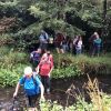
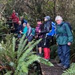
12/11/2025. Three Peaks, Escarpment, Cloud Forest Loop. Grade 3.5. Trampers. Leaders: Sarah McCormack and Karen McInnis.
Pine Hill, Mount Cargill round trip. 2023 -1991 (4 trips, 1 with report and photos – 23/9/2023)
Sullivans Dam, Cloud Forests, Escarpment, Cowan round trip. 2022-2005 (10 trips, 5 with reports and photos, 2 with photos only, 5 with no report or photos)
Sullivans Dam. 2009 – 1998 (7 trips – no reports or photos)
Leith Saddle, Sullivans Dam, Bridle Track, Pigeon Flat. 2006 – 1999 (4 trips – no reports or photos)

 12/11/2025. Three Peaks, Escarpment, Cloud Forest Loop. Grade 3.5. Trampers. Leaders: Sarah McCormack and Karen McInnis.