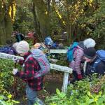
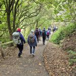
 01/07/2026. Wander Windy Waverley. Grade 2. Combined. Leaders: Bruce & Jenni Wright, Pam Cocks, Graeme Souter
Forty hardy souls met at Bayfield Park adorned with appropriate winter gear to counteract the crisp beautiful winter’s day.
Taieri Recreational Tramping Club
Mid-week recreational and social walking group based in Mosgiel NZ

01/07/2026. Wander Windy Waverley. Grade 2. Combined. Leaders: Bruce & Jenni Wright, Pam Cocks, Graeme Souter
Forty hardy souls met at Bayfield Park adorned with appropriate winter gear to counteract the crisp beautiful winter’s day.
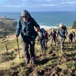
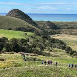
 24/06/2026. Graham’s Bush/Mt Cargill Rd Quarry Track. Grade 4. Trampers. Leaders: John Gardiner & Alison Evans.
An overcast, but dry morning, saw 19 keen trampers convene at the end of Hall Rd, then set off at 10.15 am through Graham’s Bush for Mt Cutten and the nearby Len Lye memorial.
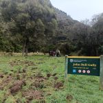 24/06/2026. Taieri Ferry to John Bull Gully and return. Grade 2. Hikers. Leaders: Janette Abbot & Jill Thomas.
A frosty 2 degrees start for 25 happy hikers as we headed off beside a very muddy and flooded Taieri River.
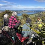
 10/06/2026. Boulder Beach. Grade 3. Trampers. . Leaders: Pam Cocks and Gail Williams.
Twenty trampers met at the top of McMeeking road on a stunning Dunedin day, sunny with little wind. Continue reading “Boulder Beach”
 10/06/2026. Flagstaff. Grade 3. Hikers. Leaders: Phil Keene and Barbara Shackell.
Such a lovely morning. We were all away from the meet n greet sharpish and organised at the Bullring where 16 hikers were away up the Pineapple/Flagstaff track at 9.45am on the dot.
 03/06/2026. Deep Stream Pipeline. Grade 3. Combined. Leaders: Sylvie Watt and Wendy Langley.
On a lovely day we all set out heading to the Deep Stream bridge just beyond Clarkes where the Mc Donalds had opened their gate so we could all park in the paddock. Continue reading “Deep Stream Pipeline”
 27/05/2026. Pineapple Track / Nicols Creek. Grade 4. Trampers. Leaders: Karen McInnnes and Sarah McCormack
17 mud loving trampers met at Tanner Road on a brisk Dunedin morning for our “workout”.
Continue reading “Pineapple Track / Nicols Creek”
 27/05/2026. Grahams Bush and Organ Pipes. Grade 3.5. Hikers. Leaders: Mike Webb and Bruce Spittle.
On a cold frosty morning 18 hikers rendezvoused at the Emanuel Church car park in Sawyers Bay at 0930 for what proved to be a challenging hike.
 20/05/2026. Town Belt/Bullock Track/Woodhaugh Gardens. Grade 2. Hikers. Leaders: Jan Palmer & Sue Beal.
It was a bitterly cold start to the day. We had a brief gathering at Memorial Park before heading to the Southern Cemetery meeting the town folk who were joining us.
Continue reading “Town Belt/Bullock Track/Woodhaugh Gardens”
 20/05/2026. Nyhon and Hereweka Tracks. Grade 3.5. Trampers. Leaders: Esther Willis & Lyn Keene.
It was so chilly in our usual Mosgiel meeting place, our car at least discussed drinking our coffee and returning home, however the temperature at Portobello was balmy by comparison.
 29/04/2026. Signal Hill from Ravenbourne. Grade 4. Trampers. Leaders: Sandy Webb & Gail Williams.
23 trampers met at Rimu St and began the trek uphill via the Signal Hill and Telecom tracks.
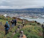
 29/04/2026. Macandrew Bay, Company Bay, Camp Road, Pukehiki, Greenacres Track. Grade 3.5. Hikers. Leaders: Jenni Wright & Jill Dodd.
The weather gods were on our side as we left Mosgiel and arrived for our destination, Macandrew Bay car park, where we met our Dunedin and Brighton contingent
Continue reading “Macandrew Bay, Company Bay, Camp Road, Pukehiki, Greenacres Track”
 22/04/2026. Bayfield Park/Around Eastern side of Harbour. Grade 2. Hikers. Leaders: Jenny Finnerty, Jay Devlin, Jan Butcher and Pam Clough.
Leaving Memorial Park it was not looking good weather-wise but it soon cleared on arriving at Bayfield Park although hats & gloves were needed. Continue reading “Bayfield Park – Around Eastern side of harbour”
 15/04/2026. Cedar Farm to Mount Cutten. Grade 3.5. Hikers. Leaders: Wendy Langley and Jill Thomas.
On a bright sunny morning with no wind 12 of us set off up to the Cedar Farm reservoir.
 15/04/2026. Kaik-Otakou. Grade 3. Trampers. Leaders: Sylvia Watts and Carolyn Pridham.
On a super lovely day we headed down the Otago Peninsula to Otakou all stopping near the bus stop.