Click on Map to Enlarge
Taieri Recreational Tramping Club
Mid-week recreational and social walking group based in Mosgiel NZ

The post that links all the known previous trips and information.
Click on Map to Enlarge
Click on Map to Enlarge

Click on Map to Enlarge
Click on Map to Enlarge

Click on Map to Enlarge

Click on Map to Enlarge

TRTC in liaison with the Green Hut Track Group undertakes to maintain those tracks on Swampy and Flagstaff on the Silverstream side above Rollinsons Road. This page groups together those trips where track maintenance has been undertaken by the Club.
Also included on this page is planting activities undertaken with the Halo Project which is an Otago based organization within Predator Free Dunedin who work collaboratively to protect and strengthen communities.
Road distances from Mosgiel carpark.
06/05/2026. Flax Clearing Day. Combined. Leaders: John Gardiner and Graham Thurlow.
06/05/2026. Track Clearing – Boulder Beach Leader: Pam Cocks.
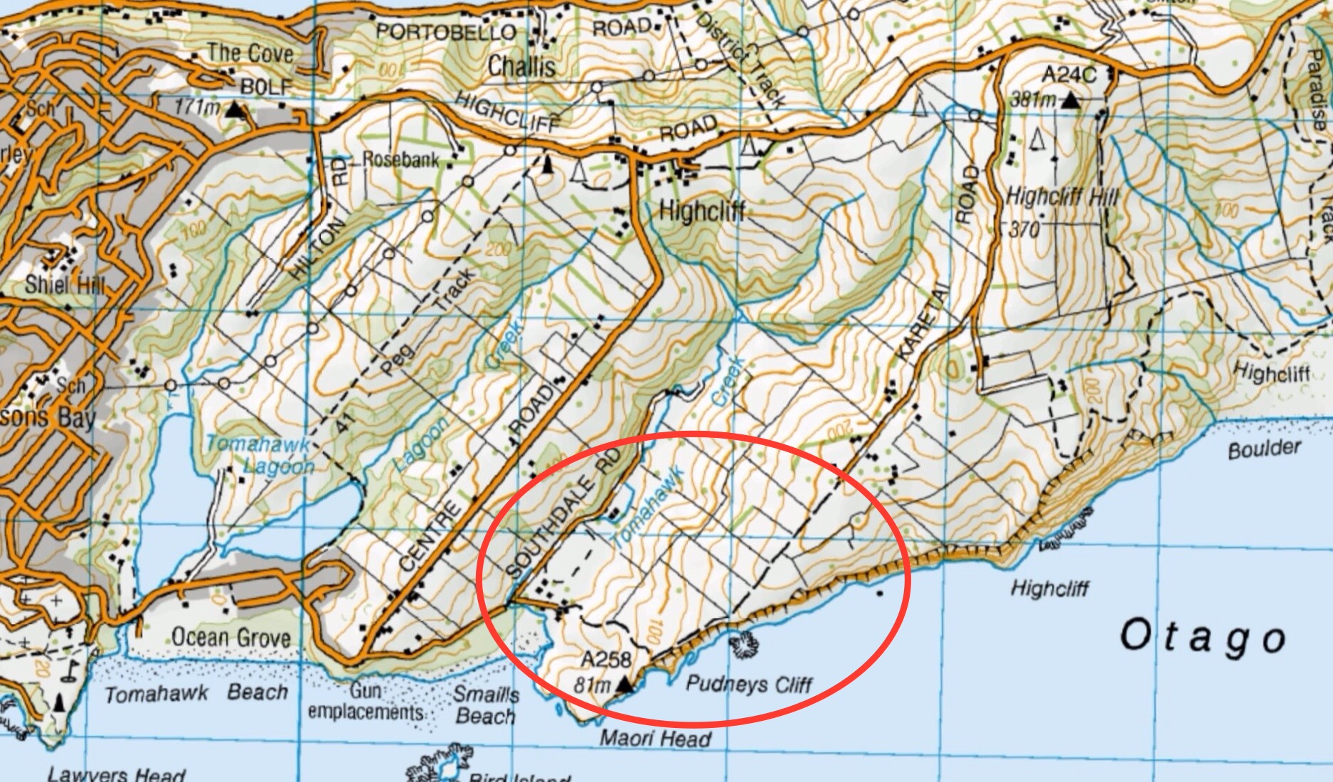
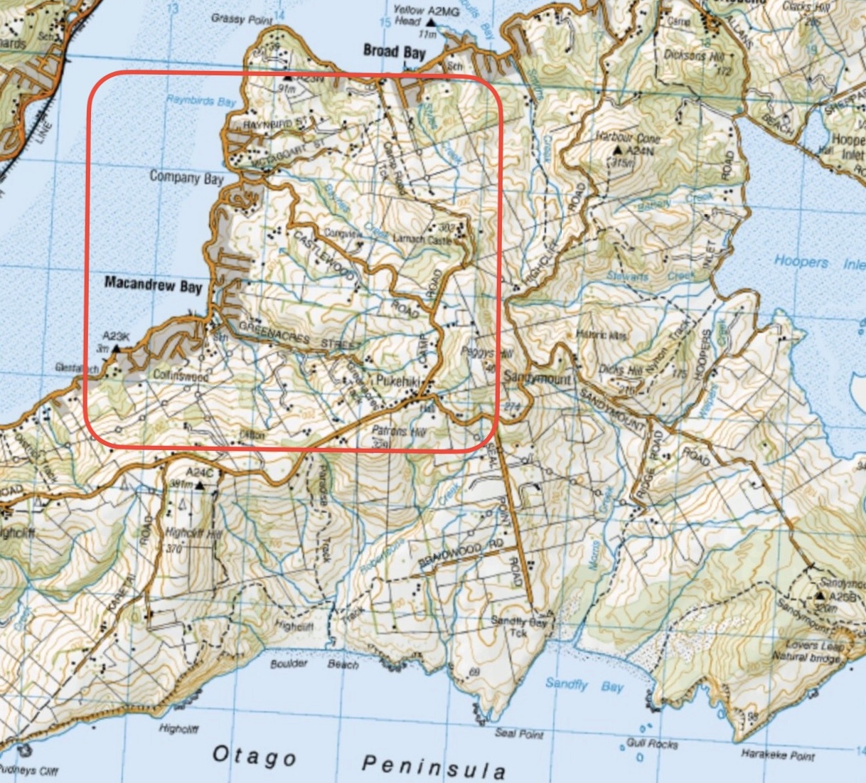
05/11/2025. Future Forest – Broad bay. Grade 2.5. Combined. Leaders: Jenny Flack, Linda Partridge, Gwenda Farquharson, Pam Cocks.
06/08/2025. Halo Project. Combined. Leader: Jill Dodd
11/04/2025 Flax/ Track Clearing. Trampers. Leader: Phil Keene.
26/03/2025. Flax / Track Clearing. Trampers. Leader: Phil Keene.
21/03/2025. Track Clearing. Leader: Phil Keene.
18/11/2024 Track Clearing. Leader: Phil Keene.
Halo Project Planting 2024 Combined Leader: Jill
Track Clearing 2024 – 2004 (27 trips, 16 with reports and photos, 10 with reports only, 1 with no report or photos)
This page of club tramps and hikes in the North via Gordon Road area and groups together trips incorporating Taioma, Mt Allan, Parera. (map)
Road distances from Mosgiel carpark.
Access Permissions maybe required as trips to Taioma and Mt Allan can venture onto Wentia Forestry land and the Taieri Gorge Railway line – refer guidelines
Note: You are not allowed to be on the railway line unless you have permission. Furthermore it is Private Property on Garroway’s cottage at Parera.
TRTC Grading Information – trips incorporating these tracks are generally given a TRTC grading of about 3. This is indicative only, as trips can be allocated a higher or lesser grading depending on the route taken. For more detailed analysis refer to Grading Information.
Background information on Salisbury property
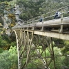
Background Information for Wingatui Viaduct Taioma Hike (20/8/2025)
Upon leaving Peter Johnston Park drive to the main street of Mosgiel (Gordon Road) and turn right. Follow Gordon Road about 1 km to the five way cross roads and go straight through onto Taioma Road. This road will cross the Taieri Plains and onto a zig zag section of road which will ascend a fairly steep hill and into Mt Allen forest. Continue on the gravel road which will descend across the railway line to Mullocky Creek and up to an area (before a locked gate) where parking is available.
13/05/2026. Mt Allan area/Mullocky Stream to Parera. Grade 3. Combined. Leaders: Sylvie Watts and Carolyn Pridham.
08/04/2026. Taieri View Farm Tramp. Grade 3. Trampers. Leaders: Jill Reid and Sue Johnstone.
20/08/2025. Wingatui Viaduct. Grade 2.5. Hikers. Leaders: Maria MacNee, Bill Cubitt..
Taioma, Parera, Viaduct. 2023 – 1988 (18 trips, 4 with reports and photos, 2 with photos only, 1 with report only, 11 with no reports or photos)
North Taieri Church, Salisbury, Taieri River Lookout off Taioma Road 2018- 1992 (10 trips, 4 with reports and photos, 2 with reports only, 1 with photos only, 3 with no report or photos)
Boulder Hill from Taioma Road. 1999 – 1988 (3 trips, no reports or photos)
Outram Bridge, Taieri View, Taioma Road. 1997 – 1998 (2 trips, no reports or photos)
This page of club tramps and hikes in the Fairfield, Green Island and Mosgiel surrounds area and groups together trips incorporating Chain Hills, Abbots Creek and Friends Hill.
Road distances from Mosgiel carpark.
TRTC Grading Information – trips incorporating these tracks are generally given a TRTC grading of about 2. This is indicative only, as trips can be allocated a higher or lesser grading depending on the route taken. For more detailed analysis refer to Grading Information.
Restrictions: Crossing of main rail line is not permitted
03/09/2025. Fairfield via Abbotts Creek Track to Wingatui and Mosgiel. Grade 2.5. Combined. Leaders: Barbara Shackell, Jenni Wright, Sandy Webb and Esther Willis.
Chain Hills-Friends Hill Tramps. 2024 – 1989 (47 trips, 20 with reports and photos, 2 with photos only, 25 with no reports or photos)
This page of club tramps and hikes in the Fairfield, Green Island and Mosgiel surrounds area and groups together trips incorporating Saddle Hill.
Road distances from Mosgiel carpark.
Saddle Hill Hotel – Historical background information
Access Permissions are required as trips to Saddle Hill venture over a working farm – refer guidelines
TRTC Grading Information – trips incorporating these tracks are generally given a TRTC grading of about 2. This is indicative only, as trips can be allocated a higher or lesser grading depending on the route taken. For more detailed analysis refer to Grading Information.
04/03/2026. Saddle Hill. Grade 3-3.5. Combined. Leaders: Esther Wills, Lynn Keene, Jill Dodd, Katherine Martin.
Tramps associated with Saddle Hill, (Makamaka). 2020 – 1989 (42 trips, 6 with reports and photos, 3 with photos only, 33 with no report or photos).
Saddle Hill, Fairfield. 2010 – 1990 (3 trips, 1 with report and photos, 2 with no reports or photos)
This page of club tramps and hikes to the Leith Valley area and groups together trips to Moores Bush (map) incorporating Leith Saddle, Patmos Ave and Sullivans Dam.
Road distances from Mosgiel carpark.
TRTC Grading Information – trips incorporating these tracks are generally given a TRTC grading of about 3. This is indicative only, as trips can be allocated a higher or lesser grading depending on the route taken. For more detailed analysis refer to Grading Information.
Ascend the Leith Valley road out of Dunedin and take a left turn into Thompsons Road, and not far along is the entrance, signposted but fenced, to this Forest and Bird Society property.
19/02/2025. Moores Bush & Sullivan Dam. Grade 2.5. Hikers. Leaders: Pam Clough, Jay Devlin.
Patmos Avenue, Leith Saddle, Moores Bush. 2017 – 2002 (5 trips, 1 with photos, 1 with report and photos, 3 with no reports or photos)
 16. 8/11/2023. Trampers. Mt Hyde. Grade 3.5. $7. 24km. Leaders: Anne Ward, Di Bezett, Lyn Keene
This page of club tramps and hikes in the Dunedin Central City area groups together trips from the Bull Ring (Flagstaff / Whare Flat Road) and incorporates the Flagstaff Walkway, Pineapple Track and Ben Rudd shelter. (map)
Road distances from Mosgiel carpark.
Location: 13.3 km from car-park.
TRTC Grading Information – trips incorporating these tracks are generally given a TRTC grading of about 3. This is indicative only, as trips can be allocated a higher or lesser grading depending on the route taken. For more detailed analysis refer to Grading Information.
Dunedin’s Hills’ History for background information.
Pineapple Track for background information.
Pineapple and Flagstaff walk for background information.
Flagstaff Name for its origin.
Ben Rudd Article for background information.
Access to the Bull Ring (and the Pineapple Track) on Flagstaff is off the Flagstaff-Whare Flat Road. This can be accessed off Three Mile Hill Road by turning left at the top of Three Mile Hill and continuing approx. 5 minutes to the Bull Ring carpark.
10/06/2026. Flagstaff. Grade 3. Hikers. Leaders: Phil Keene and Barbara Shackell.
23/10/2024. Flagstaff, Bull Ring. Grade 2.5. Hikers. Leaders: Theresa White, Julie MacKenzie.
Bull Ring, Flagstaff Walkway/ Pineapple Track. 2018 – 2008 (8 trips, 3 with reports and photos, 2 with photos only, 3 with no reports or photos)
Bull Ring, Ben Rudd. 2024 – 1995 (13 trips, 3 with reports and photos, 10 with no reports)
This page of club tramps and hikes in the Dunedin Central City area groups together trips to Mt Cargill via Cowan Road, Sullivans Dam, Cloud Forest Track, 3 Peaks Track, Escarpment Track. (map)
Road distances from Mosgiel carpark.
Map: Sullivans Dam, Cloud Forest, Telegraph (Old Bridal) track to Pigeon Flat, Escarpment Track, Cowan Rd, Short Cut to Fox Rd, down to Sullivans Dam – drawn 2002. – click on Sullivans Dam, Cloud Forests, Escarpment, Cowan round trip link below.
TRTC Grading Information – trips incorporating these tracks are generally given a TRTC grading of about 3. This is indicative only, as trips can be allocated a higher or lesser grading depending on the route taken. For more detailed analysis refer to Grading Information.
(1) Sullivans Dam – drive north along the one way street system to David Street and turn right. Follow the road through the traffic lights to Malvern Street (past Woodhaugh Garden). Continue up Malvern St to Morrisons Road (where the seal ends) and cross the overbridge (over SH1) to Sullivans Dam.
(2) 3 Peaks Track – this is accessed off Cowan Road. Take the one way street system north and turn right just before the motorway onto Pine Hill Road. Continue on this road to the very end and turn right onto Cowan Road.
Links to tramps and hikes in this area:
12/11/2025. Three Peaks, Escarpment, Cloud Forest Loop. Grade 3.5. Trampers. Leaders: Sarah McCormack and Karen McInnis.
Pine Hill, Mount Cargill round trip. 2023 -1991 (4 trips, 1 with report and photos – 23/9/2023)
Sullivans Dam, Cloud Forests, Escarpment, Cowan round trip. 2022-2005 (10 trips, 5 with reports and photos, 2 with photos only, 5 with no report or photos)
Sullivans Dam. 2009 – 1998 (7 trips – no reports or photos)
Leith Saddle, Sullivans Dam, Bridle Track, Pigeon Flat. 2006 – 1999 (4 trips – no reports or photos)
This page of club tramps and hikes in the Silver Peaks area groups together those trips to the Greengage Track (map) which incorporates Raingauge Spur, Swampy Ridge, Rollinsons and Green Ridge Tracks.
Road distances from Mosgiel carpark.
TRTC Grading Information – trips incorporating these tracks are generally given a TRTC grading of 5. This is indicative only, as trips can be allocated a higher or lesser grading depending on the route taken. For more detailed analysis refer to Grading Information.
The Greengage Track runs between Raingauge Spur and the Green Ridge Track. There is a number of ways to access this track – the following provides 3 options.
Option 1 – via Raingauge Spur which is via Rollinsons Road and will require a key to the gate approx. 2 km’s from the “Elbow” where the Raingauge track starts. A key is currently held by the club President.
Option 2 – via the Swampy Ridge Track. Access to the summit of Swampy is via Rollisons Road (option 1) with the track commencing from the Swampy Summit. This route joins the Green Ridge which forks with Greengage.
Option 3 – via Waitati. Turn left onto Double Hill Road which joins Semple Road to the starting point of he Green Ridge Track.
30/10/2024. Greengage Track. Trampers. Leaders: Graeme Souter and Graham Thurlow.
Greengage Track. 2019-2014 (3 trips with reports and photos)