
 23/10/2024. Flagstaff, Bull Ring. Grade 2.5. Hikers. Leaders: Theresa White, Julie MacKenzie.
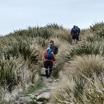
19 hikers left P/J car park with a warning of 23 degrees, so take plenty of water. Fortunately for us there was a breeze that got stronger, and the heat was manageable. Continue reading “Flagstaff, Bull Ring”
Tag: Bull Ring
Bull Ring, Flagstaff Walkway, Ben Rudd, Pineapple Track – Information and Trips Library
Scope:
This page of club tramps and hikes in the Dunedin Central City area groups together trips from the Bull Ring (Flagstaff / Whare Flat Road) and incorporates the Flagstaff Walkway, Pineapple Track and Ben Rudd shelter. (map)
Background Information:
Road distances from Mosgiel carpark.
Location: 13.3 km from car-park.
TRTC Grading Information – trips incorporating these tracks are generally given a TRTC grading of about 3. This is indicative only, as trips can be allocated a higher or lesser grading depending on the route taken. For more detailed analysis refer to Grading Information.
Dunedin’s Hills’ History for background information.
Pineapple Track for background information.
Pineapple and Flagstaff walk for background information.
Flagstaff Name for its origin.
Ben Rudd Article for background information.
How To Get There:
Access to the Bull Ring (and the Pineapple Track) on Flagstaff is off the Flagstaff-Whare Flat Road. This can be accessed off Three Mile Hill Road by turning left at the top of Three Mile Hill and continuing approx. 5 minutes to the Bull Ring carpark.
Links to tramps and hikes in this area:
10/06/2026. Flagstaff. Grade 3. Hikers. Leaders: Phil Keene and Barbara Shackell.
23/10/2024. Flagstaff, Bull Ring. Grade 2.5. Hikers. Leaders: Theresa White, Julie MacKenzie.
Bull Ring, Flagstaff Walkway/ Pineapple Track. 2018 – 2008 (8 trips, 3 with reports and photos, 2 with photos only, 3 with no reports or photos)
Bull Ring, Ben Rudd. 2024 – 1995 (13 trips, 3 with reports and photos, 10 with no reports)