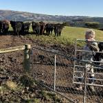
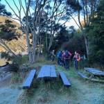
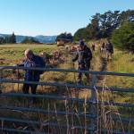
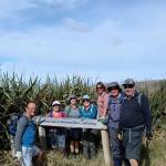
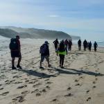
 23/7/2025. Nichols Farm. Grade 3.5. Hikers. Leaders: Wendy Langley and Carol-Anne Buchanan.
19 hikers set off on a chilly, crisp morning which provided us with a perfect blue sky and no breeze.
Taieri Recreational Tramping Club
Mid-week recreational and social walking group based in Mosgiel NZ

23/7/2025. Nichols Farm. Grade 3.5. Hikers. Leaders: Wendy Langley and Carol-Anne Buchanan.
19 hikers set off on a chilly, crisp morning which provided us with a perfect blue sky and no breeze.
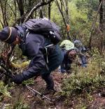
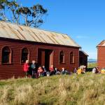
 23/7/2025. Steve Aimes / North Coal Creek. Grade 4. Trampers. Leaders: Graham Thurlow and Neil Hodgkin.
On a crisp frosty morning 16 hardy trampers met in the frost at the Silverstream carpark…….
 09/07/2025. Coutts Farm. Grade 3. Hikers. Leaders: Bruce Wright and Peter Beal.
Left Memorial Park carpark at 9.30am and travelled to Taieri Mouth, meeting up with Brighton hikers at Coutts Gully Road carpark.
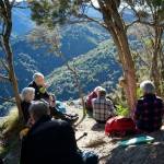
 09/07/2025. Peak Bagging from Cedar Farm. Grade 4. Trampers. Leaders: Sarah McCormack and Ross Davies.
It wasn’t the best of days; it wasn’t the worse of days. It was a day you might stay home in the warm, or it was a day you might go out peak bagging.
 18/06/2025. Millennium Track return from Henley. Grade 3.5. Trampers. Leaders: Sarah McCormack and Heather Kirk
A very frosty morning greeted all 18 of us trampers as we arrived at the Henley end of the Millennium track.
 18/06/2025. Frasers Gully – Friends Hill. Grade 3.5. Hikers. Leaders: Janette Abbott and Maria MacNee.
Woollen hats, gloves and puffer vests were needed as twelve club members and one visitor, Alison……
 07/05/2025. Waikouaiti – Matakana. Grade 2.5. Combined. Leaders: Carol Thurlow, Jill Thomas and Clare Banks (with much help from Graham Thurlow)
35 hikers and trampers set off from the Waikouaiti Sports Ground walking down to the beach heading north, marvelling at how peaceful the sea was on a very still sunny day.
This page of club tramps and hikes in the Dunedin Central City area groups together trips from to the Eastern side of Otago Harbour incorporating the cycle / walkway on Portobello Road, Glenfalloch, Waverley, Andersons Bay, Musselburgh, Highcliff, Rotary Park. (map)
Road distances from Mosgiel carpark.
TRTC Grading Information – trips incorporating these tracks are generally given a TRTC grading of about 2. This is indicative only, as trips can be allocated a higher or lesser grading depending on the route taken. For more detailed analysis refer to Grading Information.
(1) Bayfield Park – drive along Portsmouth Drive and turn right into Shore Street. Bayfield Park is located about 100 meters from the intersection with Portobello Road on the left. Toilets are available at the pavilion located on the sports fields.
(2) Vauxhall Yacht Club– drive along Portsmouth Drive and turn left over the causeway and follow Portobello Road to the Vauxhall Yacht club carpark located on the left about 5 minutes from the end of the causeway. Toilets are available at the carpark.
Links to tramps and hikes in this area:
01/07/2026. Wander Windy Waverley. Grade 2. Combined. Leaders: Bruce & Jenni Wright, Pam Cocks, Graeme Souter
22/04/2026. Bayfield Park/Around Eastern side of Harbour. Grade 2. Hikers. Leaders: Jenny Finnerty,
Bayfield carpark to Glenfalloch. 2023 (1 trip with report and photos)
Waverley, Andersons Bay, Musselburgh. Street Walks 2022 – 2000 (7 trips, 3 with reports and photos, 1 with photos only, 3 with no reports or photos)
 dd/mm/yyyy. Trip Name. Grade X. Trampers or Hikers or Combined. Leaders: Name and Name.
[paste beginning of report]
 26/03/2025. Flax / Track Clearing. Trampers. Leader: Phil Keene.
A splendid day attracted 8 splendid machinists/trimmers/hackers/rakers or…….and we headed up on to Swampy.
 26/03/2025. St Kilda / Tomahawk Beach. Grade 1.5 Hikers. Leaders: Wendy Langley and Val Cayford.
The proposed hike for today was to head up the Pineapple track and check out the surrounding area.
This page of club tramps and hikes in the area West via SH87 (inland on the south side of SH87) groups together trips to Deep Stream pipeline. (map).
Road distances from Mosgiel carpark.
TRTC Grading Information – trips incorporating these tracks are generally given a TRTC grading of about 3. This is indicative only, as trips can be allocated a higher or lesser grading depending on the route taken. For more detailed analysis refer to Grading Information.
Access Permissions are required as trips following the Deep Stream pipe line venture over a working farms – refer guidelines.
General Information – Deep Stream Water Supply
How To Get There:
Follow State Highway 87 from Outram past the Clarks Junction turn off at the bridge that traverses Deep Stream. Permission to park on farmland will be required.
03/06/2026. Deep Stream Pipeline. Grade 3. Combined. Leaders: Sylvie Watt and Wendy Langley
Deep Stream-Hindon Pipe Line from Highway 87. 2019 – 1989 (13 trips, 4 with reports and photos, 1 with report only – photo lost, 8 with no reports or photos)
Deep Stream, Rocklands Station. Welshs Road. Lawlors Old Farm. 2018 – 1989 (14 trips, 5 with reports and photos, 1 with photos only, 8 with no reports or photos)
Deep Stream Pipeline by Highway 87 (upstream) 2017 – 2007 (4 trips, 4 with reports and photos)
 09/03/2025 to 14/03/2025 . Queenstown Camp (Kelvin Heights)
Sunday 9th March 2025 travel to Lakeland Park Christian Camp on Kelvin Heights Peninsula.
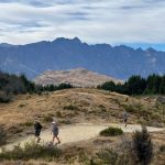
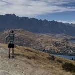 09/03/2025 to 14/03/2025 . Queenstown Camp. Queenstown Hill, Wilsons Bay, Bobs Cove. Trampers, and Hikers. Leaders: Anne and Rod Ward, Di and Chris Bezett.
Continue reading “Queenstown Camp 2025 Day 1: Queenstown Hill, Wilson’s Bay, Bobs Cove”
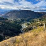 09/03/2025 to 14/03/2025 . Queenstown Camp. Moonlight Track from Arthurs Point. Combined. Leaders: Anne and Rod Ward.
Continue reading “Queenstown Camp 2O25 Day 2: Moonlight Track from Arthurs Point”