
 09/03/2025 to 14/03/2025 . Queenstown Camp – Mt Crichton Loop, Sawpit Gully, German Hill, Bush Creek. Trampers & Hikers. Leaders: Anne and Rod Ward, Di and Chris Bezett.
Author: Graeme
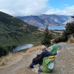
Queenstown Camp 2025 Day 4: Wye Creek, Kawarau Bike Trail, Gibbston Tavern.
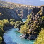 09/03/2025 to 14/03/2025 . Queenstown Camp. – Wye Creek, Kawarau Bike Trail, Gibbston Tavern. Trampers, and Hikers. Leaders: Anne and Rod Ward, Di and Chris Bezett.
Continue reading “Queenstown Camp 2025 Day 4: Wye Creek, Kawarau Bike Trail, Gibbston Tavern.”
Mt Cargill / Forrester Park
 12/02/2025. Mt Cargill / Forrester Park Grade 3. Hikers. Leaders: Bill Cubitt and Peter Beal.
The best laid plans of mice and men! We discovered late in the piece that most of the Mt Cargill track was closed for maintenance.
Powder Ridge to Long Ridge (return)
 12/02/2025. Powder Ridge to Long Ridge (return). Grade 5. Leaders: Pam Cocks, Esther Willis.
Fabulous day – and the writer is officially pooped.
Phil de Choc (Phil’s Fudge Recipe)

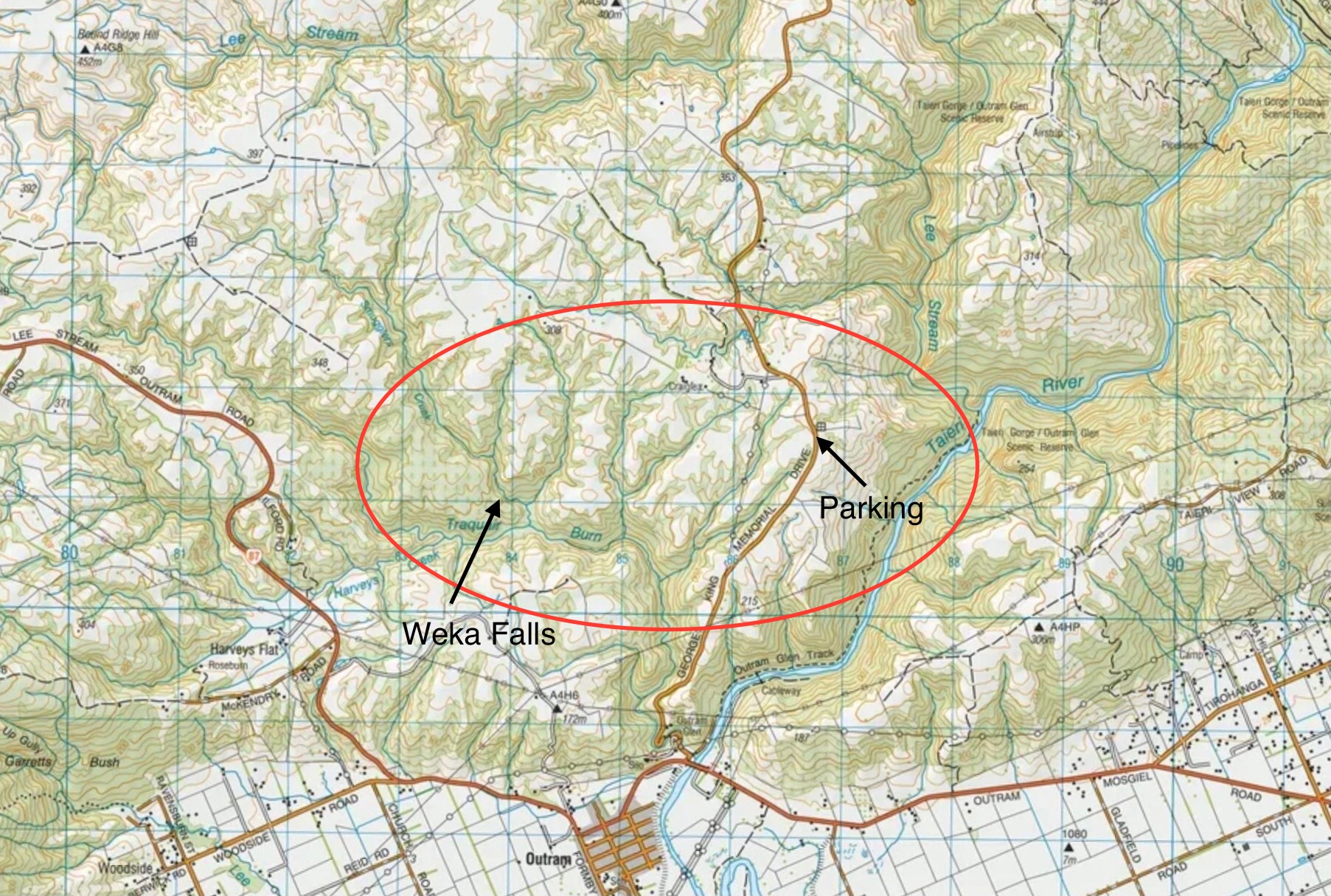
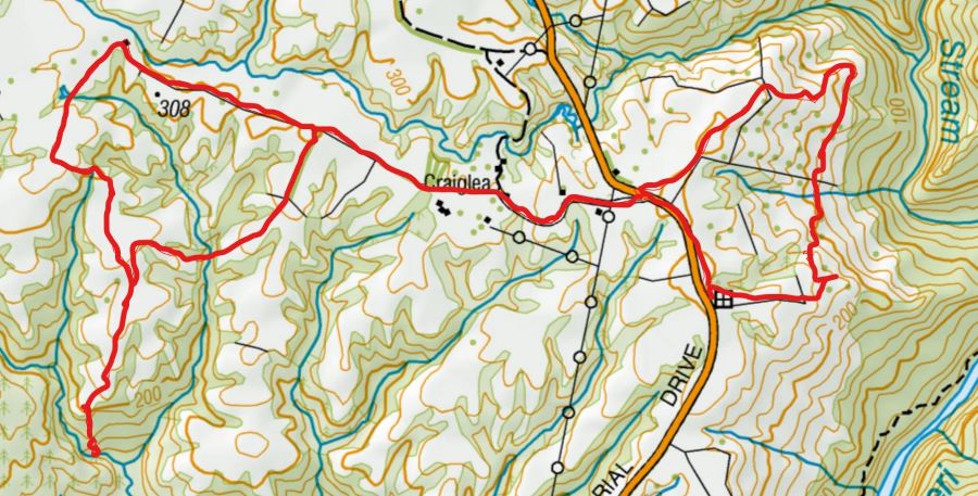
Maps – Roulston Farm, Weka Falls
Click on map to enlarge:
Catlins / Owaka Surrounds – Trip Information and Trip Library
Scope:
This page of club tramps and hikes in the South Coast area groups together trips to the Catlin’s Area including Owaka environs. (map)
Background Information:
Road distances from Mosgiel carpark.
TRTC Grading Information – trips incorporating these tracks are generally given a TRTC grading of about 2. This is indicative only, as trips can be allocated a higher or lesser grading depending on the route taken. For more detailed analysis refer to Grading Information.
How To Get There:
To Owaka Township – proceed south on SH1 to Balclutha and turn left onto the Southern Scenic Route. Continue on the Owaka Highway to reach Owaka township. A detour is available via Kaka Point Road which loops back to the Owaka Highway.
Links to tramps and hikes in this area:
21/01/2026. Owaka / Catlins Environ. Grade 2.5. Hikers. Leaders: Bill Cubitt and Peter Beal
Roulston Farm, Weka Falls – Information and Trip Library
Scope:
This page of club tramps and hikes covers trips West of SH87 which includes trips to Roulston Farm and Weka Falls (map)
Background Information:
Road distances from Mosgiel carpark.
TRTC Grading Information – trips incorporating these tracks are generally given a TRTC grading of about 4. This is indicative only, as trips can be allocated a higher or lesser grading depending on the route taken. For more detailed analysis refer to Grading Information.
Access Permissions are required as this trip ventures over a working farm – refer guidelines
Restrictions: lambing September-November
How to Get There:
Travel towards Outram township and turn hard right after bridge over the Taieri River (before Outram). Proceed onto George King Memorail Drive and continue approx 4 km for parking (in paddock on right)
Links to tramps and hikes in this area:
28/01/2026. Roulston Farm. Grade 4. Leaders: Jill Reid, Lenore Armstrong.
Weka Falls / Roulston Farm. 2021 – 1991 (9 trips, 3 with reports and photos, 6 with no reports or photos)
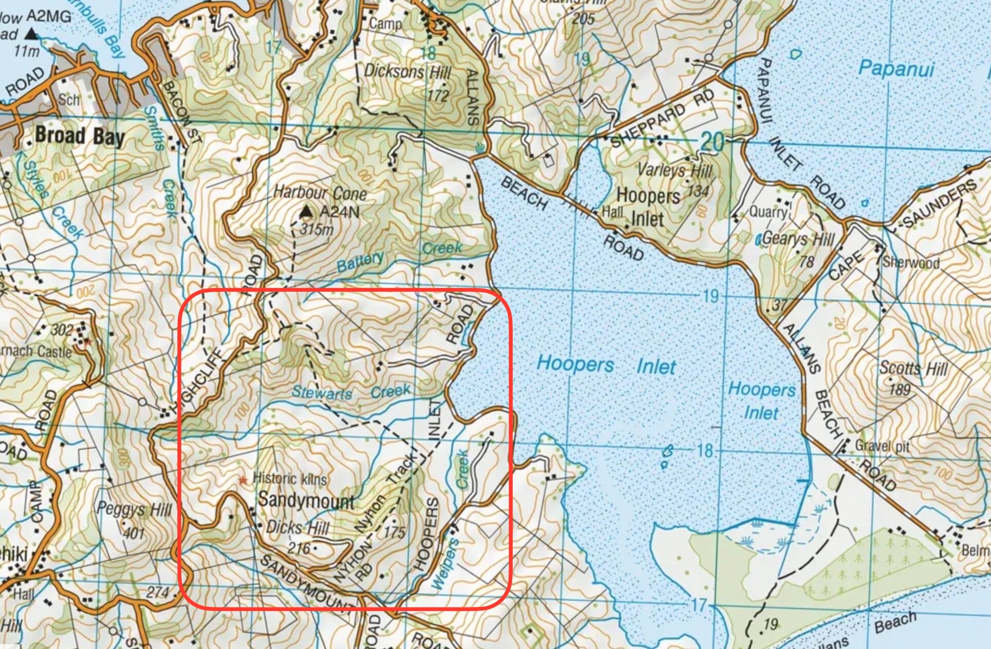
Maps – Hoopers Inlet, Rutherfords, Nyhon Tracks
Click on Map to Enlarge
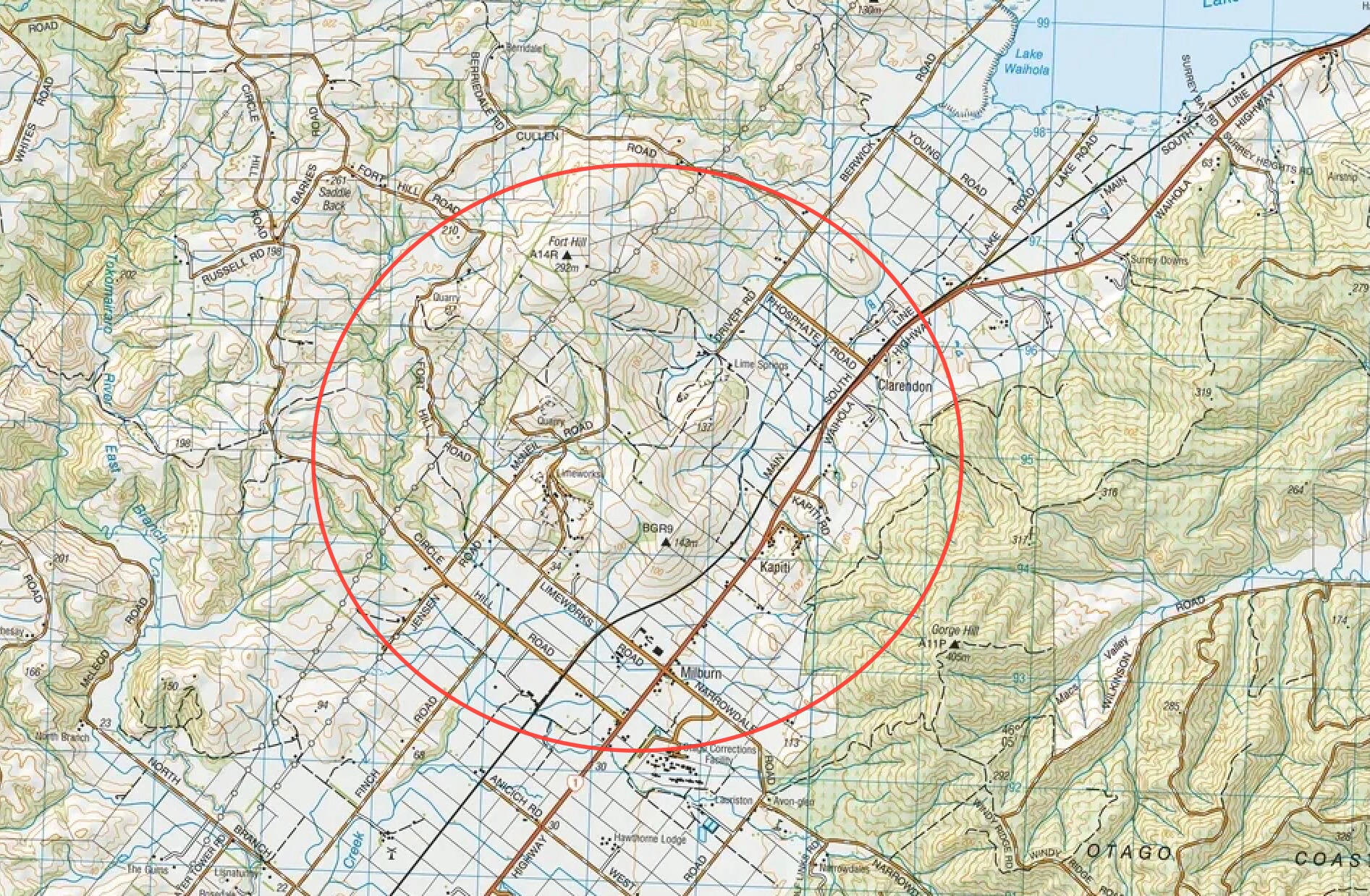
Maps – Clarendon Area (Milburn, Lime Works etc)
Click on Map to Enlarge
Whale Fossil Lookout, Clarendon Cemetery/Lime Springs – General Information
Prepared by Bruce Spittle (trip 28 January 2026)
Claredon Cemetery:
The Claredon cemetery was previously called the Waihola Gorge cemetery and the hill it is on top of has been called the “mound”. There are several unmarked graves but the names of several well known families from the area can be read on the remaining tombstones including Yorston, Young, Bell, Fryer, Sinclair, Sutherland, Craigie, Donald McMaster, Rev John McNicol and HB Flett.
Historic stable:
The stable was completed in 1884 with stone from the hill behind it, took two years to build and has 12 stalls. It was built for Henry Driver, 1831-1893, who was born in the USA, and came to Otago in 1861 from the Australian gold diggings as a youth after gold was found at Gabriels Gully. In 1881 Driver purchased the 2,000 acre homestead block of what was originally the 50.000 acre Run 52. He was a merchant and stock agent in Dunedin, was on the first City Council and the Provincial Council and was an MP for Roslyn. He was a prominent member of the Dunedin Jockey Club and responsible for laying out the race track at Forbury in 1877. Driver lived in an elegant house with a turret in Drivers Road, Dunedin. His farm was then called Horseshoe Bush and was run by a manager. The first horses stabled included thoroughbred hacks, cobs and carriage horses.
Limestone quarry:
Henry Driver opened a lime quarry on his property and in 1876 James McDonald purchased a part of Horseshoe Bush Estate for a lime works which in 1889 was taken over by the Milburn Lime and Cement Company. The company produced up to 80,000 tons of stone for cement and lime for agriculture. Milburn is locally known for its lime works with the Milburn Lime and Cement Works having been founded in 1888. The company ceased operations in 1967, The quarry is now operated by Milburn Lime.
Phosphate quarry:
In 1902 Ralph Ewing formed a company to quarry, burn and market as a fertiliser the phosphate rock on the hill behind the stable. By 1904 The Ewing Phosphate Company was regarded as one of the leading industries in NZ. A railway track about a mile long took the rock to the burning ground and then to the siding at Claredon where the brick building was built is 1918. At its peak, fifty tons a day of phosphate rock were railed to Dunedin. The mines were worked from 1902–1924 and from 1943–1955. About 200,000 tons were extracted. At 50 tons a day 200,000 tons would take 4,000 days to mine, about 11 years. However, the rock was actually mined for 36 years so production must have been lower at some stages. The business ended after competition occurred with cheaper phosphate from Nauru. There was a short revival in 2009 when Milton dairy farmers Tony and Sue McDonnell interested Ravensdown in mining the phosphate deposits at Clarendon and phosphate rock from the area was mixed with imported rock to make a product called Clarendon Gold. Ravensdown has also imported rock from Morocco, Vietnam, and Christmas Island. It recently announced plans to stop manufacturing superphosphate fertiliser at Ravensbourne and limit manufacture to Christchurch and Napier. Ravensbourne will remain a distribution centre. The 450 ha South Otago phosphate deposit is one of only two in NZ with the other being on the sea floor in the Chatham Rise. Mr McDonnell was reported in the Dairy Exporter Magazine as saying that apparently he and his neighbours had the only phosphate deposit in Australasia.
Fort Hill:
The Taieri River and its surrounding areas hold significant cultural and historical importance for the Māori people. The river was a crucial food-gathering area for coastal iwi, who would make seasonal trips inland to harvest wild foods such as birds, fish, and kouka (cabbage trees). The Taieri Plains, located in the upper reaches of the river, are known for their fertile farmland and have been a vital part of Māori farming practices for generations. The river’s unique land-forms and biodiversity make it a unique and important natural resource for the Māori community. Possibly Fort Hill was named because it had some significance to Maori. Murray Cullen, over whose land option 1 tramp, mentioned there was a rock cave nearby. On the recce the two aerials on the top of the hill were surrounded by pine trees and long grass with no obvious roads or caves being seen.
Clarendon Area, Stone Stables, Lime Works, Whale Museum and Lookout – Information and Trip Post
Scope:
This page of club tramps and hikes in the South Coast via SH1 area groups together trips to the Clarendon area (Milburn) incorporating the Lime Works, Stone Stables, Fort Hill, Whale Fossil Museum / Lookout. (map)
Background Information:
Road distances from Mosgiel carpark.
TRTC Grading Information – trips incorporating these tracks are generally given a TRTC grading of about 2. This is indicative only, as trips can be allocated a higher or lesser grading depending on the route taken. For more detailed analysis refer to Grading Information.
Background History of Stable and Cemetery
Whale Fossil Lookout, Clarendon Cemetery/Lime Springs – General Information
How To Get There:
(1) Proceed south on SH1 past Lake Waihola and turn right onto Phosphate Road. Continue on this road to the intersection of Berwick Road and Driver Road. Turn left and continue to the end for parking.
(2) Proceed south on SH1 past Lake Waihola to Milburn (before Milton) and turn right onto Limeworks Road. Continue over the rail lines and take the first right to the lime works. Can continue to McNeil Road intersection, turn right and proceed to Fort Hill Road (next left) and quarry.
Links to tramps and hikes in this area:
28/01/2026. Whale Fossil Lookout, Clarendon Cemetery/Lime Springs . Grade 3. Hikers. Leaders: Bruce Spittle, Eleanore Ryan.
Clarendon Area, Stone Stables, Lime Works, Whale Museum and Lookout. 2017 – 1991 (16 trips – 3 with reports and photos, 2 with report only, 2 with photos only, 9 with no report or photos)
Akatore Creek to Taieri Mouth
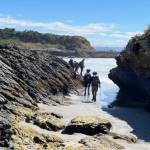 15/01/2025. Akatore Creek to Taieri Mouth. Grade 3. Trampers. Leaders: Spen Walker and Jane Bruce.
We gathered at PJ Park on a fine sunny morning, and Phil welcomed us to the first trip of the year.
Moeraki Millennium Track Moeraki Township to Moeraki Boulders
15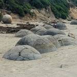 /01/2025. Moeraki Millennium Track Moeraki Township to Moeraki Boulders. Grade 2.5. Hikers. Leaders: Neville Griffiths and Dave Roberts.
A group of 13 hikers in 4 cars made the trip to Moeraki and met up at the car park adjacent to the public toilets in the Moeraki township.
Continue reading “Moeraki Millennium Track Moeraki Township to Moeraki Boulders”
Rutherford, Nyhon, Hereweka Tracks, (inc Lime Kilns) – Information and Trip Library
Scope:
This page of club tramps and hikes on the Otago Peninsula groups together trips incorporating the Rutherford, Hereweka, Nyhon tracks and the Lime Kilns. (map).
Background Information:
Road distances from Mosgiel carpark.
TRTC Grading Information – trips incorporating these tracks are generally given a TRTC grading of about 3. This is indicative only, as trips can be allocated a higher or lesser grading depending on the route taken. For more detailed analysis refer to Grading Information.
Access Permissions – generally not required if using the marked tracks. Any deviation from the recognised tracks a courtesy call to the farmer (see Access Permissions page – Peggy’s Hill) would be in order.
Nyhon Track is closed for lambing Set – Oct.
How To Get There:
(1) Proceed along Portobello Road to Portobello to Portobello township itself – turn right onto Hoopers Inlet Road and continue to the intersection and turn right. Follow this road around the inlet to the start of the Nyhon Track (approx 2 kms)
(2) Proceed along Highcliff Road and continue through Pukehiki to Sandymount Road. Turn right and continue to Hoopers Inlet Road and turn left. Follow this road to Hoopers Inlet and turn left to the start of the Nyhon Track.
Links to tramps and hikes in this area:
20/05/2026. Nyhon and Hereweka Tracks. Grade 3.5. Trampers. Leaders: Esther Willis & Lyn Keene.
14/01/2026. Hoopers Inlet, Rutherfords – Stewarts, Lime Kilns, Nyhon Track. Grade 3. Trampers. Leaders: Spen Walker, Jane Bruce, Sandy Webb