Hereweka / Harbour Cone Background Information

Image002
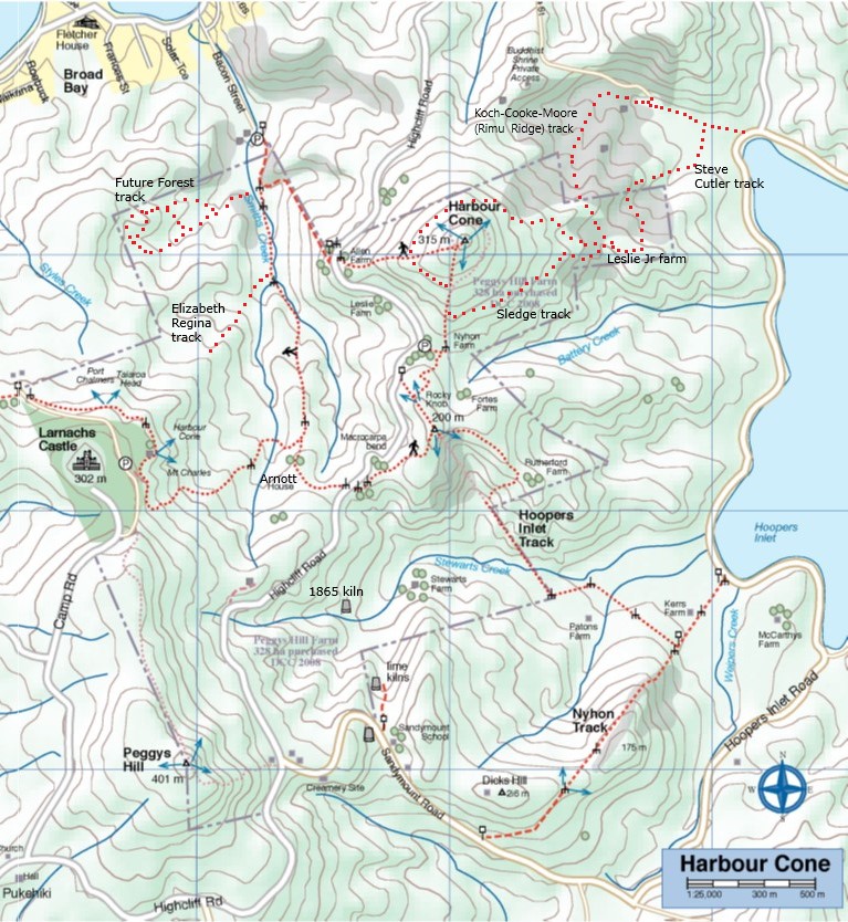
Hereweka Block map showing the marked tracks as of 2024. NB Approximate routes only for the new Around Harbour Cone track, the “Leslie loop” (Steve Cutler & KCM Rimu Ridge tracks), the Future Forest track, and the Elizabeth Regina track.

Most of the Peninsula was in the Otago Block purchased from Kai Tahu in 1844.  This isolated, steep, and heavily bushed land around Harbour Cone was subdivided in 1863. Highcliff Road was developed between Pukehiki and Portobello from about 1867 to 1869, providing access across the block.  Settlers, mainly Scottish, gradually bought sections and cleared the thick bush for their small dairy farms. Cattle could feed themselves by browsing the native bush, unlike sheep which needed short pasture.  The farmers planted macrocarpas for shelter around their homesteads – each clump of trees still marks an old house site – and built impressive drystone boundary walls.

Cows were kept under cover in byres overnight, as they had been in Britain.  Herds averaged around 20 cows, because you could only keep as many cows as the family could hand milk.  Cream was hand-churned into butter, sold in Dunedin to provide the family’s income. Skim milk was fed to pigs, and hens provided eggs.

James McDonald opened three lime kilns at Sandymount from 1865 onwards. Apparently the burnt lime produced was unsuitable for agriculture and was used for making cement. By 1882 the kilns were uneconomic, although they were occasionally reopened until 1939.

From 1872 businessman and later MP William Larnach developed a house and model farm at “The Camp”, employing a number of local tradesmen and farm workers.  His importation of stud Ayreshire and Alderney cows was instrumental in improving the Peninsula dairy industry.

In 1877 a dozen farmers formed a cooperative cheese factory, based at Capt William Leslie Sr’s property. This was successful but the venture ceased after the factory was destroyed in a major bush fire on 14 October 1881.

Home dairies were less important after 1893 when the Taieri & Peninsula Milk Supply Company, managed by local settler Walter Riddell, opened Sandymount Creamery. Farmers carried their milk to the Creamery in the morning, exchanged news with their neighbours,  and returned home with the skim milk. This Creamery  was supplied by up to 30 farmers and processed as much as 9000 litres of milk daily. Frozen butter was exported to Britain. The steady income kept these small dairy farms viable for another generation.

Portobello was the main settlement, served by ferries to Port Chalmer and Dunedin, but Sandymount also became a local centre. Sandymount School opened in 1870,  with classes held for the first two years in rooms at Walter Riddell’s house, and closed in 1949.  A Post Office was situated at Sandymount or Pukehiki from 1876 until 1952.

During the first half of the 1900s, dairy farming became uneconomic.  The dozen or so small dairy farms were gradually bought up by two local families, the Stewarts and the Nyhons, and converted to sheep farming.  In 1980 the Maori corporation Akapatiki A Block amalgamated both properties and ran the farm from Roger’s homestead.

The DCC bought the Hereweka Block in 2008 for public use and recreation.  It is managed by the Hereweka Harbour Cone Management Trust, leased out to farmer Brendon Cross  who runs sheep and some cattle.
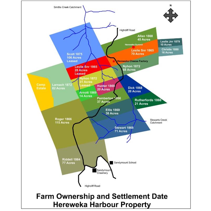
Image004

Prepared by  Jane Bruce

Background Information for Wingatui Viaduct Taioma Hike

Thanks first to Ross who provided books and information for our hike today (20/8/2025). He was a wealth of information and was able to tell me a little about his job as Railway Inspector.  In the days when there was very little health and safety, Ross and his team had the task of checking for faults and problems every 6 months all the way along the line to Alexandra and inspecting every nut bolt and joint on the Otago Central Railway line every 5 years. This  included walking a narrow plank underneath structures like the Viaduct we are looking at today, with nothing to hold on to but a thin wire. This  could take up to two weeks on a structure as big as this one.

The bridge towers sit on rollers to allow for the expansion and contraction of the metal structure. At one point the abutment on the Parera end moved inwards through natural land movement which left no room for expansion so it became necessary to cut and shorten one of the spans. Roman numerals would be stamped on the piles of the smaller bridges to indicate the depth of the piles.

There are 21 bridges between Wingatui and Pukerangi and 86 between Wingatui and Clyde not counting the smaller bridges of which there are at least another 20. All bridges and tunnels have a number.

In 1878 a survey for the proposed railway construction was completed the goal being to serve the gold mining industry initially but it was 5 years later with the gold rush waning a second commission came to the conclusion that the agricultural and pastoral needs of the province plus other mining potential (18 collieries and  possible zinc, copper, silver, mercury mining) would justify a rail link

Construction began and by the early 1880s there were as many as 700 men working on the Hindon  section from Mullocky Gully to Deep Stream. By 1884 – 5 yrs after the first sod was turned the 12.5km of formation comprising  the Wingatui and Mullocky sections were completed.

Accidents were common, the nearest doctor, Dr McCaw, lived at Mosgiel and a call meant a trip on horseback over rough tracks and through fords in the Taieri River. As the quantities of drugs and dressings that could be carried were limited, caches of medical supplies were provided in government huts  along the construction route.

In 1880, a one-roomed school  6.8 x7.3 metre, was built beside the line midway between Mullocky Gully and Parera. It catered for 30-40 pupils for 5 yrs but had neither blackboard nor fireplace.

Mullocky Gully was thought to be named after  one Donald Malloch who with his brother John delivered mail fortnightly from Waikouiti to the Manuherakia on horseback. Early in his career he got hopelessly lost between Shag Point and Strath Taieri and nearly died before finding shelter in a shepherd’s hut.  Thereafter, the gully concerned became known as ‘the place where Malloch got lost’ subsequently mutating to “Mullocky Gully” (Hocken Library) Other references  refer to a  James Malloch who was working in the area from as early as 1861 – same man? However “mullocky” is also the waste material  left after ground had been worked over.

PARERA   Refers to the rare and endangered native Grey Duck which  resembles the introduced common female Mallard and is often confused with it.  Pure Grey Ducks are rare as many have become hybridised with the Mallard. Pure Grey Ducks have grey feet, the Mallard and hybrid Grey have  orange and plumage differs. Male Grey Ducks are simply larger than the female whereas the male Mallard has much more flamboyant plumage.
Be on the lookout.  We are assuming Parera and Duck Tunnel are named after the Grey Duck.

References:  Over The Garden Wall; Otago Central Railway 1879-1990; From Sea to Silver Peaks; Hocken Library

Cheers
Maria Macnee

Tunnel Gully, McRaes, Racemans, Powder Creek Detour

Crossing Silverstream Upper (1)14/08/2024. Tunnel Gully, McRaes, Racemans, Powder Creek Detour. Grade 3. Trampers.  Leaders: Phil Keene & Gary Mort.
27 trampers in 6 cars all managed to end up at the Tunnel Gully entrance at the same time and after arranging for two cars to be parked at the main Silverstream car park we all set off just after 10.00am.

Continue reading “Tunnel Gully, McRaes, Racemans, Powder Creek Detour”

Delights of St Clair

150 Square24/07/2024. Delights of St Clair. Grade 1.5. Hikers.  Leaders: Neville Griffiths, Wyn Davies.
After parking our cars and meeting up with the Taieri Hikers in Moana Rua Road, 20 Hikers headed off just after 10am and walked across the Kettle Park Sports field towards Marlow Park.
Continue reading “Delights of St Clair”

Macandrew Bay, Company Bay, McTaggart St, Camp Road, Pukehiki, Greenacres Street

Square 150

24/07/2024. Macandrew Bay, Company Bay, McTaggart St, Camp Road, Pukehiki, Greenacres Street. Grade 3. Trampers, Leaders: Yan Campbell, Jenny Flack.

Continue reading “Macandrew Bay, Company Bay, McTaggart St, Camp Road, Pukehiki, Greenacres Street”

President’s Update – July 2024

July 2024 Update: Taieri Recreational Tramping Club 

Hi everyone, time for another update as there has been a recent committee meeting  and to take an opportunity to highlight a few things; but first: 

Membership and Welcome 

To new members approved by the Committee – Denise Hammer, Charlotte and Chris  Handley, Sandra Lawn, Peter Dodds, Sue Beal, Shirley and Noel McRandle, Spen Walker  and Jane Bruce, Annette MacRae, Clare Banks and Lisa Harkness – I hope I have not  missed anyone! Great to have you with us and hopefully I’ll be able to keep up with you  all! 

Committee Deliberations 

  • We agreed with the President’s recent advice to the Taieri Network in support of  their submission to the Clutha Council to provide public toilets in the Titri Bridge  area.  
  • We discussed the suggestion for the club to initiate and maintain a Facebook page,  either private or public. There are a range of matters to consider; who would  maintain administration and standards, what topics would be covered vis a vis what  would be on the website etc. At this stage it was agreed we would further deliberate  and if you have suggestions, please let a committee member know. 
  • We discussed the current membership level (130) and the suggestions made to us  that the club could close membership/ limit it to Taieri residents or charge a much  higher joining fee! etc. We are in agreement that the club’s biodiversity is  strengthened by having an ‘open to all’ membership ethos, many of the committee  and a high percentage of track clearers do not live on the Taieri! There are  approximately 45 members who either do not walk or do not walk regularly but like  to donate to the club as well as keep in touch with our comings and goings and we  welcome that approach. We will however continue to monitor the situation. 
  • With now larger groups we would encourage everyone to re-read the Trip Guidelines  especially those guidelines that cover faster and slower walkers, bi furcations (ask  Dr Esther or Dr Google) and also the guidelines will be amended to cover the  scenario of injured or unwell walkers. It was agreed that depending on the context  of a trip a minimum of two and a maximum of four should return to the vehicles with  an unwell participant (where PLBs are not used). As a matter of practice, it pays to  keep an eye out for those behind you as much as those in front of you. 
  • If I make a successful return from Perth in early August I’ll take a few minutes at  lunch on the combined walk to talk to these points.
  • We have updated and confirmed with the Rescue authorities the process and  contacts for management of the club’s personal locator beacons. 
  • In anticipation of the AGM we agreed recommendations to keep joining and membership fees at the current level ($10.00 each) and also approved the honoraria for Webteam, Secretary-Treasurer and Reviewer of Accounts. For the latter this will be the last year that Keith McKenzie will audit the accounts and we acknowledge the work he has done for us over the years. From next year Trevor Flack will undertake the review of accounts. Thanks Trevor in advance for this. 
  • We had it explained to us the process the communication officer undertakes to set passenger fees for fuel reimbursement and agreed that the current process, based on AA data is working well. At this time, we will not be changing the $$ levels but will  reconsider at the time of compiling the summer programme. 
  • As previously advised at an earlier meeting we agreed for the Webteam to undertake changes to the website, to refresh if you like and to make it cleaner clearer and simple to use and to work around. You will have noticed this has started  to happen, maybe in parallel with some wet days, and it is still a work in progress.  Please feel free to suggest to the Webteam members any ideas or improvements. 
  • We are in the process of finalising AGM agenda items (22 August) and we will provide sometime for the Webteam to have a session to explain the changes and to provide feedback on aspects that will help everyone when you provide information for publication. 
  • Roger Leslie from East Taieri has accepted an invitation to speak to us at the AGM. He was recently featured in the ODT supplement covering his new book, ‘On the Verge’ which details his exploits in walking NZ in aid of mental health. He and his wife have just returned from Europe where Roger also shore sheep in Germany and participated in ultra marathons. It was exhausting listening to him. 
  • At the AGM Marijke will have some small paintings of where she has tramped for show and sale as a fundraiser for the Southland Hospice so come prepared (all the materials donated by herself and of course her talent and time) – no pressure! 

Well, that’s it, a lot happening in our neck of the woods – so keep warm while you walk  and talk. 

Raewyn and I will be in Perth for a month hoping for sun and warmth, home 1 August so see you 7 August. 

Cheers, Phil


Link to President’s Update information Library  for previous updates

Nicols Creek, Moon Track, Pepper Tree Track, Pineapple Track

Out Of The Mist Ross Square26/06/2024. Nicols Creek, Pineapple Track. Trampers. Grade 4. Leaders: Wyn and Ross Davies.

The weather forecasts were not very encouraging. Nevertheless, 12 courageous trampers arrived at the meeting point at Booth Road Continue reading “Nicols Creek, Moon Track, Pepper Tree Track, Pineapple Track”