April 2024 Update: Taieri Recreational Tramping Club
Hi everyone, as mentioned at this week’s meet n greet, we have had recent Committee and Trip Committee meetings, so this is a summary of what is happening.
Welcome
To Alison Kim and Sandy Webb who have had their membership approved which increases our health and wellbeing capability considerably! We look forward to enjoying your company.
From the Committee meeting
- Guests – First Outings – a reminder
It is in the guidelines that it is the leaders’ responsibility for talking with guests to establish their capability, medical history and expectations etc. From the Trip Organisation Guidelines: “Leaders have the discretion as to who participates on the day.” If a member is inviting a guest to attend, it is their responsibility to contact the leader of the trip so that there are no surprises on the day.
Note also, where there is the possibility of bad weather affecting the start of a trip it is not always possible to get emails out in time on the day. The header to the printed Trip Programme sets out the process but if in doubt pick up the phone and ring the trip leaders directly.
- Briefing Members on Trip Organisation Guidelines
It was agreed that we should take five minutes or so every so often, to reinforce key aspects from the guidelines. Ideally it would be done informally over lunch on walks. Watch this space.
- Locator Beacons
It was noted that the third locator beacon is now with Phil Keene for use during track clearing if needed. There are two separate issues to keep in mind with the beacons. The first is possession and the second is contact people for emergencies and Jenni will check with the authorities as a first step to confirm who is listed as contact points.
- Ramblers’ Formalisation?
It was agreed that the status quo is working fine. Those who are wanting to shorten a walk should communicate with the leaders and as long as there are two or more willing to go back, then that is considered to be OK. If using separate transport, they should contact the leaders to confirm they have left the area safely.
- Committee Members Standing for 2024/25 at the AGM.
In terms of our constitution all positions need to be appointed each year and there is no set term if elected to any position. Phil advised that he will be standing aside as President (and would become Immediate Past President) and will continue to coordinate track clearing. John would be happy to continue in the Vice-President’s role, as would Ross and Jenni in their respective roles. Jay and Jan, after many years of service, will also be standing down, as will Karen. Barbara, Pam, and Graeme S would be happy to be nominated again.
- Webteam
Welcome and thanks to Graeme Souter for taking on this additional role. This brings the number of Webteam members to five, headed by Ross Davies. They do a professional and important function for the club. Many thanks.
- Fuel Compensation for Track Clearing
The Committee noted that around 140 hours of track clearing had been undertaken so far this summer season. In the past, some money had been budgeted to pay members a reimbursement for using their vehicles for track clearing. Phil moved that we formalise a fund to compensate for those using their vehicles. This fund would be distributed in the form of gift vouchers to help offset petrol costs, the value to each worked out at the discretion of the President bas ed on the record of attendance. The budget for this year was set at $300.
Trip Programme to 30 October 2024
Following on from the committee meeting, the Trip Coordinators and teams have met and developed the programme for the next six months and this can be printed from the website now and/or accessed via Upcoming Trips on the home page. A reminder that the latter is always the most current list as changes to the programme are noted there. Many thanks to everyone involved in getting this completed so ably and quickly.
Please have a look to see where your name appears and if you have any queries or concerns speak to me or John and Jay as the Trip Convenors.
We have revised the fuel reimbursement levels and note in some cases the gradings may change following a recce by the trip leaders and a final route option determined. A confirmation of the grade in the leaders trip report is always welcome as this helps with future trip programming.
Note:
- the change to winter start times is on 5 June
2. to diary the 3 July for the mid winter Tunnel Beach walk and lunch at the Concord Tavern 3. the AGM on 22 August at the Mosgiel-North Taieri Presbyterian Church, 11 Church St, Mosgiel (behind Mitre 10).
Photos for trip write ups
Recently we have been approached and asked to remove a photo from a write up and this we have been happy to do. The instance concerned a photo taken on a private property and we need as a matter of courtesy to be aware of how we take and or use such photos.
Finally
More thanks to Anne and her team for the week at Kelvin Heights. Listening to folk talk about the week plus looking at the photos made me pretty envious.
Last update I said we should hopefully look forward to a warm and dryish summer, which we have had, so why not wish the same for the next six months!
Happy walking and talking
Phil
Link to President’s Update information Library for previous updates

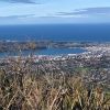 13. 17/04/2024 Bullring/ Ben Rudd/ Flagstaff Grade 2.5 Leaders: Mike and Dave
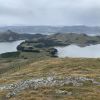 12. 10/4/2024 Mt Charles Grade 4 Leaders: Graham and Carol Thurlow
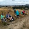 47. 10/04/2024 Highland Park to Friends Hill. Grade 2.5. Leaders: Margaret Maxwell/Kay Seddon.
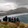 25. 27/03/2024. Hikers. Sandymount Grade 2.5 Leaders: Jenni and Bruce Wright
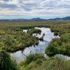 5. 04/04/2024. Combined. Sinclair Wetlands. Grade 1.5. Leaders Ady, Linda, Dave and John.
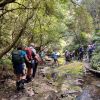
 I’ve always regarded myself as, and indeed endeavoured to be, an optimist. But on Tuesday night, I had serious doubts that Wednesday’s tramp would proceed. That night seemed to leave little room for optimism. A Wednesday morning early dog walk gave a glimmer of hope, that the weather, although unpredictable, might be improving. Seventeen ‘optimistic’ trampers took part on the Split Rock tramp.
 17. 13/03/2024. Trampers. Carey’s Creek, Rongomai, Honeycomb Tracks. Grade 3.5. $11. 39km. Leaders: Pam Cocks, Graeme Souter.
 15. 06/03/2024. Combined. Waikouaiti
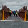 22 hikers assembled at a car park in Limeworks Road, Milburn on a rather grey morning with a cold head on sou’wester blowing into our faces. After traversing a farm track, we joined the Clutha Gold Trail in Circle Hill Road and began what Jill quite accurately described as a day of quirky bridges and old fossils!
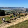 18. 14/2/2024. Trampers. Maungatua Option. Leaders Lyn Keene, Anne Ward and Di Bezett
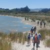 14. 14 February 2024. Hikers. Waldronville Wander. Grade 2. $5. 10km. Leaders: Phil Keene, Helen Morris.