Millennium Track from Taieri Ferry Rd, Finlayson Rd, Galloway Rd, Bells Farm, Kennedys Farm, Wenita (Morrisons Block) – Information and Trips Library

Scope:

This page covers the Club tramps and hikes in the area South via SH1 and groups together trips to the Millennium Track  (Henley end) located on Lower Taieri River commencing on Taieri Ferry Road. (map)

Background Information:

Road distances from Mosgiel carpark.
Taieri River Geology for some background information.
Legends of the Lower Taieri includes a section about John Bull if you persist in reading down far enough.
High tides flood the access road and this has happened to us more than once. N.B. Programme Committee! Avoid high tides forecast near the the hours of 9.00 a.m. or 2.00-3.00 p.m.”
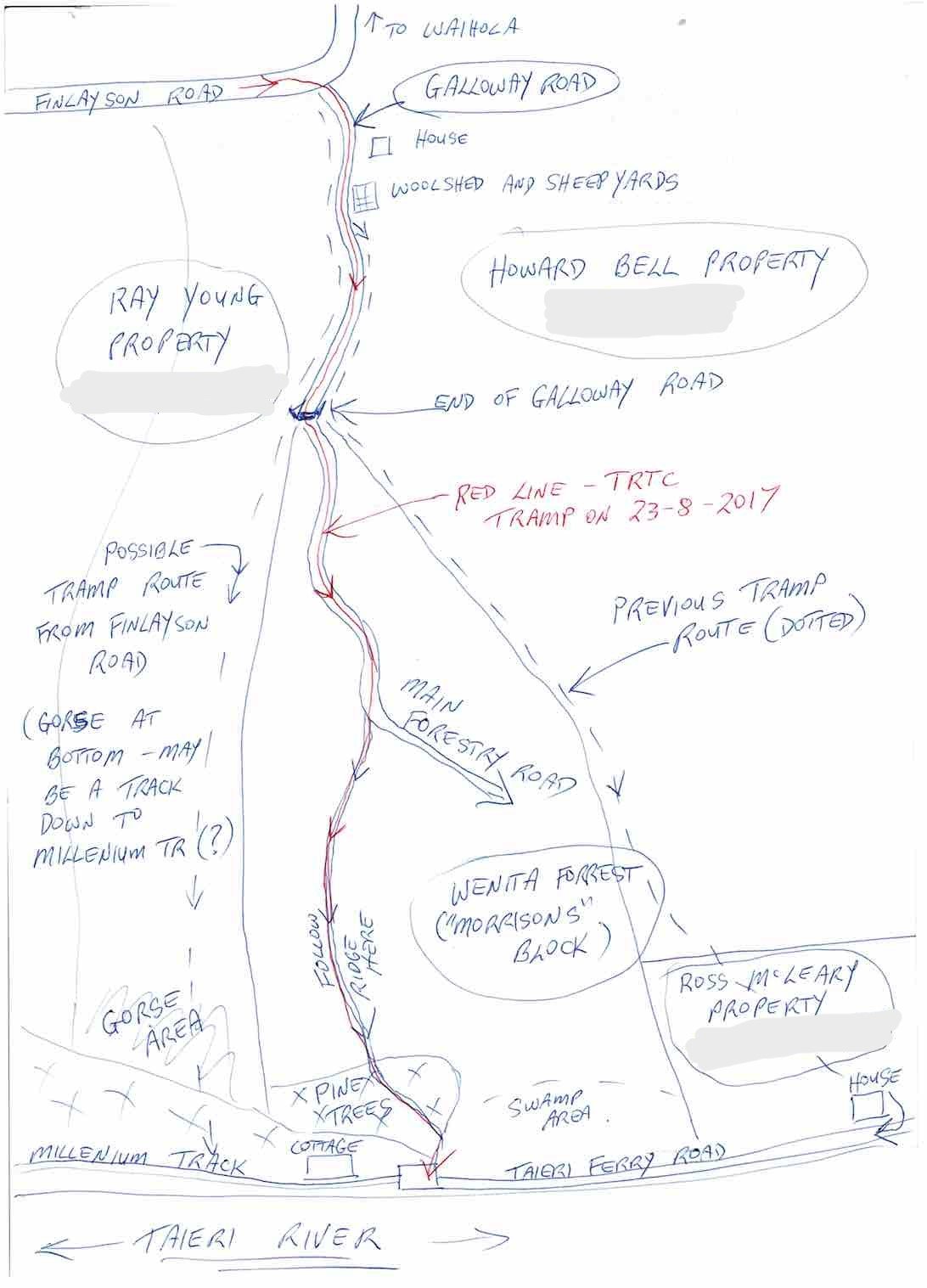
2018 Trampers – Millennium Track, Taieri Ferry Rd. to Taieri Mouth and return – “We walked 18.6 km’s.  Similar times of 2 1/4 hours each way. ”
Bell Farm.  (2002) Seek access permission. Lambing Aug to Oct. Cars park halfway down Taieri Ferry Road, end of forest. Up hill till lunch time. Wenita permit. Wenita Map.
Galloway Rd – Taieri Ferry Rd tracks, see map below. Seek access permission.

Links to tramps and hikes in the same area:

14/08/2024. Taieri Mouth Excursion. Hikers.  Leaders: Bill Cubitt & Alex Griffin.
24/07/2024.Millennium Track return, Henley Start. Trampers.  Leaders: Gwenda Farqharson. &  Alison K.


Taieri Ferry and Finlayson Roads, Bells Farm, Kennedys, Millenium (1994 – 2023, 18 trips)
Millennium Track (2002 – 2017, 17 trips with 3 reports)
John Bull Gully Track and Millennium – from Henley and Taieri Mouth (1993 – 2016, 17 trips with 6 reports).


Galloway Copy
Galloway Road tracks map. (Map courtesy Arthur.)


Grahams Bush, Organ Pipes, Buttars Peak, Mt Cargill – Information and Trips Library

Scope:

This page of club tramps and hikes in the West Harbour area groups together trips to Grahams Bush,(map) the Organ Pipes, Buttars Peak and Mt Cargill.

Background Information:

Road distances from Mosgiel carpark.
Grahams Bush Botanical Information (1988) (from DoC information sheet).
Mt Cargill – Information (from DoC information sheet).

Links to tramps and hikes in the same area:

09/10/2024. Graham’s Bush to Mt Cargill.  Trampers.  Leaders: Karen McInnes and Gail Williams

Grahams Bush, Old Main Rd, Organ Pipes, Buttars Peak, Mt Cargill, Mt Cutten, Bethunes Gully, Upper Junction  (2024 – 1989, 18 trips with 11 reports).
Grahams Bush, Upper Junction, Brickhill Rd (2014 – 1993, 15 trips with 4 reports).
Grahams Bush, Careys Bay (2004, 1 trip, no report).
From Old Mount Cargill Road Lookout (1992, 1 trip, no report)

Concord – Information and Trips Library

Background Information:

Road distances from Mosgiel carpark.
See also Tunnel Beach – Information and Trips Archive for Tunnel Beach trips starting at Concord.

Links to tramps and hikes in the same area:

17/07/2024. Concord Creations. Hikers.  Leaders: Jan Butcher.  &  Jenny Finnerty.

Concord Blackhead (1989 – 2015 (4 trips with only 1 report)).

Tunnels, McRaes, Racemans, Top Weir, Silverstream – Information and Trips Library

Scope:

This page of club tramps and hikes in the Whare Flat area groups together trips within the Silverstream catchment and includes Racemans, Tunnel Gully, Powder Creek and Chalkies.

Background Information:

Road distances from Mosgiel carpark.
Racemans Track, Weir, Origins.
Whare Flat School and Surrounds History.

Links to tramps and hikes in this area:

14/08/2024. Tunnel Gully, McRaes, Racemans, Powder Creek Detour. Trampers.  Leaders: Phil Keene & Gary Mort.
26/06/2024. Whare Flat, Waiora, Schoolhouse, Tunnels Track, McRaes Weir, Racemans. Hikers. Leaders: Bruce Spittle,  Adrienne Ensor.


Pump House, Tunnels, McRaes Weir, Racemans, Return (2004 – 2020, 10 trips with 6 reports).
Schoolhouse, Tunnels, McRaes Circuit (1989 – 2019, 9 trips with 6 reports).
Silverstream Water-Race, Racemans, Weir (1992 – 2023, 21 trips with 6 reports).
Tramps Associated with the Whare Flat Schoolhouse (1995 – 2017, 5 trips with 3 reports).
School House, Tunnels, McRaes, Steve Amies, Whare Flat Road Return. 2007 (1 trip with report – no photos)

St Clair, St Kilda, Kew, Corstorphine, Ocean Grove, Tomahawk – Information and Trips Library

Background Information:

Road distances from Mosgiel carpark.
Ocean Grove, also known as Tomahawk, is a suburb in the southeast of the city of Dunedin. … The suburb was known as Tomahawk until the 1930s, the name not being a reference to the weapon, but rather possibly an anglicised form of the Māori words tomo haka, meaning “dance by a gravesite”.

Links to tramps and hikes in the same area:

07/08/2024. City to Surf. Combined. Leaders: Gail Williams, Karen McInnes, Jenni and Bruce Wright.
24/07/2024. Delights of St Clair.  Hikers.  Leaders: Neville Griffiths, Wyn Davies.


St Clair Beach Walks (1995 – 2023, 17 trips).
Street Walk: St Clair – Kew (2000 – 2022, 2 trips – 1 report).
Tomahawk Lagoon and Nearby Tracks and Areas (1989 – 2023, 43 trips, 19 reports; see 40, 38, 36, 35, 33, 29 and 26.)

Macandrew Bay, Company Bay, MacTaggart St, Camp Road, Boulder Beach,Pukehiki, Greenacres St – Information and Trips Library

Scope:

This page of club tramps and hikes on the Otago Peninsula groups together trips incorporating Macandrew Bay, Company Bay, Camp Road, Greenacres St, McTaggart St, and Pukehiki. (map)

Background Information:

Road distances from Mosgiel carpark.
MacTaggart St track closed for lambing September and October.

Links to tramps and hikes in the same area:

24/07/2024. Macandrew Bay, Company Bay, McTaggart St, Camp Road, Pukehiki, Greenacres Street. Trampers, Leaders: Yan Campbell, Jenny Flack.


Macandrew Bay, Greenacre Street (1989-2024, 12 trips with 6 reports). Hikers.
Macandrew Bay, Company Bay, McTaggart St, Camp Rd, Pukehiki, Greenacres St (1997 – 2022, 5 trips with 4 reports). Trampers, Hikers, Combined.

Nicols Creek – Information and Trips Library

Scope:

This page of club tramps and hikes to the Leith Valley area and groups together trips to Nicols Creek (map) incorporating the Pineapple Track, Nicols Falls, Moon Track and other tracks on Swampy.

Background and History

Road distances from Mosgiel carpark.
DCC land. Nicols Creek circuit maintained by Green Hut Track Group.
David Nicol was an early settler and dairy farmer. He reputedly bought land here in the hope that the railway line would be routed north through Leith Valley.
Antony Hamel’s YouTube video showing his exploration of the 5 falls of Nicols Creek.
Neighbours at War Background and photos to the Finnerty Family and their house site on the Moon Track by Nicols Creek.
Swampy ridge track background information.
Pineapple Track for background information.
Pineapple and Flagstaff walk for background information.
Nicols Creek Glow-worms

Links to tramps and hikes to the same area:

26/06/2024. Nicols Creek, Pineapple Track. Trampers. Leaders: Wyn and Ross Davies.
Nicols Creek, Swampy, Pineapple Track, Moon Track, Booth Road
Bull Ring, Swampy, Nicols, Pineapple Point, Davies, return
Nicols Creek Bridge, Morrisons Burn, Poleline Road, Swampy, Nicols or Pineapple
Nicols Creek, Swampy Saddle, Davies Track
Moon, McQuilkan, Possum Hunters, Jim Freeman, Pineapple, Nicols
Nicols Creek, McQuilkans (no reports).
Booth Rd, Nicols Creek, McQuilkan, Jim Freeman, Pineapple. Either direction (no reports)
Leith Valley, Nicols Waterfall, Sullivans Dam (no report)

Big Easy, Signal Hill, Ravensbourne, Opoho, Northern Cemetery – Information and Trips Library

Scope:

This grouping of Club tramps and hikes covers trips involving the Big Easy to Signal Hill Memorial, Ravensbourne, Opoho (incorporating Willowbank), the Northern Cemetery. (map)

Background Information:

Road distances from Mosgiel carpark.
Town Belt Article – good links to Signal Hill and Green Belt (see also Dunedin Town Belt).
Opoho Historical Background Notes

Links to tramps and hikes in this area:

16/10/2024. Ravensbourne, Signal Hill, Big Easy. Trampers.  Leader: John Gardiner.
21/08/2024. Big EasyHikers. Leaders: Pam Clough, Jay Devlin.


Signal Hill Centennial Memorial, Ravensbourne, Big Easy (2023 – 1998, 24 trips with 9 reports).
Botanic Garden, Logan Park, Northern Cemetery, Chingford, Big Easy (2021 – 1996, 25 trips with 16 reports inc. 19/05/2021 and 30/09/2015 for Big Easy).
Signal Hill Tramps (2023 – 1992, 19 trips  with 8 reports inc. 22/08/2018 for Big Easy).
Street Walk – Willowbank-Opoho area. (2022 – 2017, 2 trips with reports)

Tunnel Beach – Information and Trips Library

Scope:

This page of club tramps and hikes in the Fairfield, Green Island and Mosgiel surrounds area and groups together trips incorporating Tunnel Beach. (map)

Background Information:

Road distances from Mosgiel carpark.
Tramping Track managed by DOC. Tunnel Beach Road accessed from Blackhead Road. Plenty of parking at end of Tunnel Beach Road. Concord Tavern park for longer walk.

Tunnel Beach Walkway (general information and history).
Dunedin’s Hills’ History (brief mention of Tunnel Beach geology at the end).

Links to tramps and hikes in the same area:

03/07/ 2024.  Tunnel Beach, Concord Tavern Lunch – Mid Winter Catchup. Combined. Grade 2. Leaders: Phil and Helen Morris, Jay Devlin and Margaret Maxwell.

Tunnel Beach Archive (Hikers, Trampers, Combined)
Midwinter Dinner Occasions (including Tunnel Beach 23/06/2010).

Midwinter Dinners – Information and Trips Library

Links to midwinter dinners:

03/07/ 2024.  Tunnel Beach, Concord Tavern Lunch – Mid Winter Catchup. Combined. Grade 2. Leaders: Phil and Helen Morris, Jay Devlin and Margaret Maxwell.
Midwinter Dinner Occasions (2010-2020)
Midwinter Street Walk – Street Art (includes Midwinter dinners 2016-2021)
Waihola Walk (2017)

Millennium Track from Taieri Mouth – Information and Trips Library

Scope:

This page covers the Club tramps and hikes in the area South Coast and groups together trips to the Millennium Track  located on Lower Taieri River commencing on Taieri Mouth. (map)

Background Information:

Road distances from Mosgiel carpark.
Taieri River Geology for some background information.
Legends of the Lower Taieri includes a section about John Bull if you persist in reading down far enough.

Links to tramps and hikes in this area:

John Bull Gully Track and Millennium – from Henley and Taieri Mouth (1993 – 2016, 17 trips with 6 reports).
Taieri Mouth – Inc Millennium, Moturata Island, Akatore, Alanton Block (1989 – 2023, 15 trips with 13 reports including 29/03/2023 Millennium Track).

Street Art Walks Dunedin – Information and Walks Library

Background Information:

Road distances from Mosgiel carpark.
Street Art Trail A3 Map (2016 – not up to date)
Dunedin Street Art Map (no details other than artist name and location).

Links to art walks in the same area:  

21/08/2024 . Street Art Walk.  Trampers Leaders: Wendy Langley,Val Cayford.
10/07/2024. Street Art Trail and Surrounds. Hikers. Leaders: Wendy Langley, Val Cayford.


Midwinter Street Walk – Street Art (2015 – 2021)
Follow the Leith (2022 – 2023) University campus.

Racemans, Steve Amies Loop,Coal Creek – Information and Trips Library

Background Information:

Road distances from Mosgiel carpark.
Racemans Track, Weir, Origins

Links to tramps and hikes in this area:

Racemans, North and Little Coal Creeks, Steve Amies (2020 – 2023, 2 tramps with reports). Continue reading “Racemans, Steve Amies Loop,Coal Creek – Information and Trips Library”

Opoho – Historical Background Notes

Opoho – ‘Here my head is level with hills and sky’ – (Janet Frame)

[These historical notes were prepared by Ross for our wanderings around Opoho on 1 June 2022 on a tour led by Neil and Margreet Simpson and Wyn and Ross Davies. Only parts of it were recounted as we zoomed around, and some asked for a chance to read a bit more about what was talked about. What follows is the whole lot.]
Name of Opoho
Maori have been present in the area for 800-900 years. Two groups of Maori ovens have been found on the contours of the hill, said to have been used by people of the Ngatiwairua.
Poho is said to have been a Ngatiwairua chief in the 1700s, head of a family occupying a small kaika (village) by the outlet of the stream which flows down the hill into what was once Pelichet Bay (now Logan Park). O-poho simply means ‘Poho’s place’ and it came to be applied to the neighbouring stream – Opoho Creek.
Later it was adopted by one of the early English landowners for a subdivision on the middle slopes beside where the stream flowed (the Logan Park side), and gradually the name became applied to the whole suburb (on both sides of the ridge).
Opoho Odyssey Part 1 – Botanic Gardens Top Car Park to Knox College
Lovelock Avenue
Formerly Cemetery Road because of the Northern Cemetery halfway down. Renamed Lovelock Avenue in 1968, after Jack Lovelock who lived in Opoho while studying medicine at Otago University. It was the street he ran down every day going to university. Jack Lovelock kept running, and broke the world record for the mile in 1933. He went on to win the gold medal in the 1500 metres at the Berlin Olympics in 1936 (the first Kiwi to win an Olympic track event).
Signal Hill Road
The most enduring street name in Opoho is Signal Hill Road. It appears on all the maps. The top of Signal Hill provides a good view of the harbour and may have given the Maori a place to watch for hostile war canoes and signal from. With European settlement, the same hill was used to signal immigrant ships and perhaps to announce their approach to Dunedin residents. It remains one of the best-known landmarks in Dunedin.
Opoho Road and Trams
The original Opoho subdivision, called Estate of Opoho, to form Opoho Township was created by Captain Boyd in 1873. We’re going to wander some of the streets of this Opoho Township this morning, making our way down to Knox College for a tour at 11am. Opoho Road was the southern boundary of the Opoho Township, originally called District Road. It was the first access to the suburb from the Gardens although there was also a road to Dundas Street down Lovelock Avenue. Opoho Road was too steep where it meets Signal Hill Road for the trams, so a new loop was created through part of the Upper Gardens where the road now goes. It was the steepest line attempted by electric trams. The terminus was at the corner of Signal Hill Road and Blacks Road, and that was steep too. At least two trams ran away from the terminus when the brakes failed – with serious consequences. The tramline opened in 1924. Continue reading “Opoho – Historical Background Notes”

Stadium to the Sea

Distance from carpark: Otago Yacht Club 19 km.
City to Surf – Information and Trips Library


25/05/2022  Stadium to the Sea. E. Leaders: Raewyn & Phil Keene

Shall we hike or not? That was the question asked at PJ Park on a cold & windy morning. 10 hardy hikers said “yes”, so off we went to meet 6 others at the carpark in Magnet Street as arranged.

DSC05638 John Res 1200
Group photo before setting out (photo and caption John)

With extra clothing, beanies & gloves, we set off into stormy skies for morning tea at the Harbour Basin.

IMG20220525093530 Phil Res 1000
O’er the Leith bridge (photo and caption Phil)

Low & behold, the sun broke through so we continued on our blustery walk to Portsmouth Drive & beyond.

IMG20220525103012 Phil Res 1000
Our leader outlining the Urban Nature network (photo and caption Phil)
IMG20220525103203 Phil Res 1600
So this is why the teeth were put here? (photo and caption Phil)

Along the way we were educated by the new Urban Nature signs put up by DoC around the city (www.doc.govt.nz/urbannature) and the histories behind Rongo Rock & Fox Hall.

DSC05639 John Res 1200
At the “Rongo” Monument (photo and caption John)
24AA1E96-8683-4214-BB7C-52552D585F9D Raewynne Res 477
Fox Hall, Rongo rock and urbanNATURE (Collage by Raewynne)
IMG20220525113049 Phil Res 800
We went over Tomahawk Rd to see the views, but the Mustang was preferred (photo and caption John)

Onwards, upwards & over to the Andersons Bay Cemetery where the wind blew even harder, down to the Chisholm Golf links, then across to John Wilson Drive & the sea.

IMG20220525115150 (2) Phil Res 1000
Arnie’s army is alive and well at Chisolm Links (photo and caption Phil)

Our planned lunch stop was taken over by the high seas, so shelter was sought on high ground.

IMG20220525120902 Phil Res 1200
We were discussing Bob Dylan’s ‘shelter from the storm’ over lunch (photo and caption Phil)

AND THE WIND BLEW. Unable to walk along the beach, we braced ourselves and walked into the head wind down to Marlow park.

DSC05645 John Res 1200
Impromptu group photo (but guess who’s missing?) (photo and caption John)
IMG_7178 Noi Res 466
The boys solving the problems of the world (photo and caption Noi)

9.5km & two buses later, we were back at the Stadium for coffee at the Plaza Cafe, followed by a short walk to our cars.

IMG20220525141409 Phil Res 1200
Great coffee and service at the Plaza, we’ll be back (photo and caption Phil)

Raewyn

9B9D74C4-626C-4409-9A77-90717FEB1F14_1_201_a Raewynne Res 641
Screenshot of route by Raewynne