Sinclair Wetlands – Information and Trips Library

Scope:

This page of club tramps and hikes in the area West via SH87 (Maungatua, Waipori River, Berwick) groups together trips to the Sinclair Wetlands (map)

Background Information:

Road distances from Mosgiel carpark.

TRTC Grading Information – trips incorporating these tracks are generally given a TRTC grading of 2. This is indicative only, as trips can be allocated a higher or lesser grading depending on the route taken. For more detailed analysis refer to Grading Information.

Official Sinclair Wetlands website.

Hori Sinclair and his wetlands’origin(1st paragraph only, of treatise linking its surrounds prehistorically with Kai Point Coal Mine)

How To Get There:

From Peter Johnston Park drive to Outram. Proceed through the township and turn left onto Formby Road and then right onto Huntly Road. Follow this road, it turns into Maugatua Road and proceed to Berwick Road. Continue to McPherson Road and turn left where parking is available.

Links to tramps and hikes in this area:

Sinclair Wetlands. 2024 – 1990 (5 trips with 4 reports)


Middlemarch Area – Information and Trips Library

Scope:

This page of club tramps and hikes in the area West SH87  groups together trips to the Middlemarch area including Shannon and Sutton. (map)

Background Information:

Road distances from Mosgiel carpark.

Access Permissions are required for trips to Shannon’s Farm  – refer guidelines

TRTC Grading Information – trips incorporating these trips are generally given a TRTC grading of about 3. This is indicative only, as trips can be allocated a higher or lesser grading depending on the route taken. For more detailed analysis refer to Grading Information.

Rock and Pillar via Six Mile Creek This climbs 1,005 m. (3300 feet) up the eastern face from Glencreag Station up a leading ridge south of Six Mile Creek. This is the most direct approach.
Rock and Pillar via spur south of Lug Creek. Information: Climbs 910 m. (3000 feet) up the eastern face of a well-graded vehicle track up a leading spur south of Lug Creek. Average time to Leaning Lodge is 3 hours on foot.
DoC access. 9.5km north of the Middlemarch store on SH87, just before Lug Creek, is a farm entrance (RAPID 7219 – no DoC sign). A short way up the driveway is a DoC car park. There is public access up the vehicle track to the conservation area boundary. The track is now a recreation reserve administered by DoC.
Easiest route to Big Hut from Leaning Lodge (foot only – unmarked – good visibility essential) is another 45+ minutes climbing gently southwards to cross a steep gully and then climb a gentle shelf to above the eastern basins. Sidle several hundred metres past the lower prominent rock tors before gently descending to Big Hut once it becomes visible. Route very wind and cloud-prone. Ice axe and crampons may be necessary to traverse steep snow slopes near Leaning Lodge.
64 km to Middlemarch. 66 km to Stonehurst Track.
Redan Crater- contact for access Ken Rennick.

How to Get There:

Stonehurst Track – take SH87 to Sutton / Middlemarch. Just over the rail line at Sutton turn left onto McHardy Road then right onto Gladbrook Road. Start of track is about 1 km on left on Gladbrook Road – see DOC sign post.

Sutton Salt Lake – take SH87 to Sutton / Middlemarch. Turn left onto Kidds Road (before rail crossing). Sutton Salt Lake Reserve is approx 2.5km from turn off on the left.

Links to tramps and hikes in this area:

26/02/2025 Stonehurst Track. Grade 4. Trampers.  Leaders: Jill Reid, Sylvie Watt.

Middlemarch Area Tramps. 2023 – 1988 (16 trips with 13 reports, 1 with photos only, 2 no reports)
Jones Property, Matarae. 2022 (1 trip with 1 report)
Shannon’s Farm Walk. 2023 – 2020 (3 trips with 3 reports)

Lake Mahinerangi Farm Tramps – Information and Trips Library

Scope:

This page of club tramps and hikes in the area West via SH87 (inland on the south side of SH87) groups together trips on farms in the Lake Mahinerangi area.

Background Information:

Road distances from Mosgiel carpark.

Lake Mahinerangi and Waipori (General Information)

Links to tramps and hikes in this area:

Mahinerangi Farm Tramps. 2024 – 2011 (6 trips with 6 reports – 1 with photos only)
Mahinerangi Wind Farm. 2019 – 2011 (2 reports – photos only)
Lake Mahinerangi, Verterburn Road, Picnic Place. (6 trips, no reports)


Post Office Creek, Reid’s / Beatties Farms (Verterburn) – Information and Trips Library

Scope:

This page of club tramps and hikes in the area West via SH87 (inland on the south side of SH87) groups together trips to Post Office Creek, Reid’s and Beatties Farms (Verterburn). (maps)

Background Information:

Road distances from Mosgiel carpark.

Access Permissions  may be required depending on how Post Office Creek track is accessed. Permissions must be obtained for those trips venturing onto either Reid and/or Beattie farms – refer guidelines

TRTC Grading Information – trips incorporating these tracks are generally given a TRTC grading of about 3. This is indicative only, as trips can be allocated a higher or lesser grading depending on the route taken. For more detailed analysis refer to Grading Information.

How To Get There:

(1) Access via Reid’s / Beatties Farms (Verterburn)
Turn left of Lee Steam Outram Road (SH87) onto Mahinerangi Road. Follow this to the junction and turn right onto Kowhai Spur Road. This brings you to Verterburn and access to Post Office Creek at Lake Mahinerangi.

(2) Access via forestry walk – Lake Mahinerangi
Take the Waiporai Falls Road (off Maungatua Road) to the power station at Lake Mahinerangi. Cross over bridge below the power station and follow the unnamed road to the forest access and Post Office Creek track.

Links to tramps and hikes in this area:

25/03/2026. Post Office Creek from Mahinerangi Dam end. Grade 3. Hikers.  Leaders: Peter Dodds and Barbara Shackell.
19/03/2025. Post Office Creek via Reid Farm. Grade 3.5. Hikers.  Leaders: Bruce Spittle and Dave Roberts.

Post Office Creek, Reid’s Station. 2022 -1992 (18 trips with 7 reports including 1 with photos only)


Nardoo Scientific Reserve – Information and Trips Library

Scope:

This page of club tramps and hikes in the area West via SH87 (inland on the south side of SH87) groups together trips to the Nardoo Scientific Reserve. (maps)

Background Information:

Road distances from Mosgiel carpark.

Suggest leave Mosgiel 8.30am to get to ‘Little Peak about 1km above ‘Walrus rock’.

TRTC Grading Information – trips incorporating these tracks are generally given a TRTC grading of 4. This is indicative only, as trips can be allocated a higher or lesser grading depending on the route taken. For more detailed analysis refer to Grading Information.

Access Permissions are required as this trip ventures over a working farm (Waiporai Station / Pamu Farms of NZ) – refer guidelines   Lambing season October – November.

How To Get There:

Take Lee Stream Outram Road and turn left onto Mahinerangi Road. Follow this road to the lake past the fisherman’s huts etc and turn right onto Lammerlaw Road. Stay on this road until you reach a small parking area near the Reserve.

Links to tramps and hikes in this area:

Walrus Bridge. Nardoo Scientific Reserve. Little Peak.
2022 – 1993 (10 trips with 6 reports)


Ship At Anchor – Information and Trips Library

Scope:

This page of club tramps and hikes in the West via SH87 (inland on the South Side SH 87) and groups together trips to the Ship At Anchor. (map)

Background Information:

Road distances from Mosgiel carpark.

TRTC Grading Information – trips incorporating these tracks are generally given a TRTC grading of about 4. This is indicative only, as trips can be allocated a higher or lesser grading depending on the route taken. For more detailed analysis refer to Grading Information.

Lake Mahinerangi. From Eldorado Track, Cox’s Reef, Cosmopolitan battery, Timber Gully Waterfalls, old gold workings. (data lacking)
Eldorado Track (Waipori) year round. Locked gates. Key from DCC Water Dept.)
Long tramp. Tussock now heavy. Summer too hot? Autumn may be preferable.
How to Get There:
Take SH87 through Outram township and past Lee Stream School to Black Rock Road then turn left. Follow this road onto Lee Flat Road and to the intersection with Mahinerangi Road. Turn right and continue to Eldorado Track which is on the left before the cribs etc at Mahinerangi. Follow this road past the wind farm to the end (about 15 minutes) for parking.
Links to tramps and hikes in this area:

Ship at Anchor, Lammermoors, Deep Stream, Gold tailings, Mahinerangi.
2024 – 1989 (14 trips with 7 reports)

Nichols Farm (was Michelles Farm) – Information and Trips Library

Scope:

This page of club tramps and hikes covers trips West via SH87 which includes trips to Nichols Farm – north side of the Taieri River. (map)

Background Information:

Road distances from Mosgiel carpark.

Access Permissions are required as trips to Nichols Farm ventures over a working farm – refer guidelines

Restrictions: lambing August-November

TRTC Grading Information – trips incorporating these tracks are generally given a TRTC grading of 3. This is indicative only, as trips can be allocated a higher or lesser grading depending on the route taken. For more detailed analysis refer to Grading Information.

How To Get There:

Drive to the Outram Bridge via  Outram Mosgiel Road. Turn right before going across the bridge and park down underneath the bridge. Limited parking is available.

Links to tramps and hikes in this area:

20/08/2025. Nichol’s Farm (Michelle’s Farm). Grade 4. Trampers.  Leaders: Gail Williams, Lynley McArley.
23/7/2025. Nichols Farm. Grade 3.5. Hikers.  Leaders: Wendy Langley and Carol-Anne Buchanan.

Nichols Farm (formerly Michelles Farm), North Side Taieri River, Outram. 2023 – 1989 (15 trips with 6 reports)

Woodside Glen, Maungatuas – Information and Trips Library

Scope:

This page of club tramps and hikes covers trips West via SH87 which includes trips to the Woodside Glen and Maungatuas. (maps)

Background Information:

Road distances from Mosgiel carpark.

TRTC Grading Information – trips incorporating these tracks are generally given a TRTC grading of 3. This is indicative only, as trips can be allocated a higher or lesser grading depending on the route taken. For more detailed analysis refer to Grading Information.

How To Get There:

Take Outram Mosgiel Road to Outram, proceed through the township and turn right. Turn left off the highway (SH87 – Lee  Stream – Outram Road) just before it starts climbing the hill onto Woodside Road then right onto Ravensburn Street (5-10 minutes from turn off) and then left onto Mountain Road which leads to the Woodside Glen and the picnic area.

Links to tramps and hikes in this area:

Woodside Glen, plus to top of Maungatuas. 2024 – 1992 (18 trips with 11 reports)

Outram, Allanton, Floodbanks, Lee Stream, Scrogies Farm,Traquair, Whare Creek – Information and Trips Library

Scope:

This page of club tramps and hikes covers trips West of SH87 which includes trips to the Outram area, Lee Stream, Scroggs Farm, Traquair / Whare Creek (maps)

Background Information:

Road distances from Mosgiel carpark.

TRTC Grading Information – trips incorporating these tracks are generally given a TRTC grading of about 2. This is indicative only, as trips can be allocated a higher or lesser grading depending on the route taken. For more detailed analysis refer to Grading Information.

Restrictions: Scrogies FarmLambing Aug – Oct.

How To Get There:

Take Gordon Road from Mosgiel onto SH87 (Outram Mosgiel Road) and continue to Outram township. For trips to Lee Stream via the Outram Glen track turn right immediately after the bridge over the Taieri River for parking and toilets at the Outram Glen site.

Parking is also available at the Outram Rugby Club field. Continue through Outram township and turn left onto Formby Road. The club is situated on this road just before the intersection with Huntly Road.

To Scorgies Farm: Take Lee Steam / Outram Road (SH87) to the 1st Mahinerangi Raod and turn down left onto this road. Continue to the bridge crossing Lee Stream and park cars on the right by the farm gate.

Links to tramps and hikes in this area:

25/02/2026. Outram Glen to Lee Stream. Grade 2.5. Hikers. Leaders: Maria MacNee, Avis Williamson.
04/02/2026. Lee Stream/Scorgies Farm. Grade 2.5 (hikers), 3.5 (Trampers). Combined.  Leaders: Sylvia Watts, Lynley McArley, Phil & Raewyn Keene.
10/12/2025. Lee Stream Area – hike before Christmas Lunch. Grade 2.  Combined.  Leaders: Lyn Keene, Anne Ward, Janette Abbott, Shirley McRandle.
22/10/2025. Outram Glen and Beyond. Grade 2. Trampers.  Leaders: Jill Reid and Heather Kirk.
13/11/2024  Outram Glen to Lee Stream. Grade 2. Hikers.  Leaders: Julie McKenzie & Katrina McKenzie.
04/09/2024. Outram Heritage Trail and Floodbank. Grade 2. Combined. Leaders: Anette MacRae, Katrina McKenzie, Cathy Ferguson, Janette Abbot.

Lee Stream Road Ramble, Scorgies Farm 2023 – 2006 (7 trips with 3 reports and photos, 3 with reports only, 1 with no report or photos)
Outram – Allanton Flood Bank. 2023 – 2011 (4 trips with 3 reports).
Outram Glen Track to Lee Stream. 2023 – 1992 (15 trips with 10 reports)
Outram Museum. 2020 (1 trip with report)
Outram Glen and Traquair/Whare Creek. Cartwright Track. 2014 – 2008 (6 trips with 5 reports)

Taieri River Flood banks, Riverside Road, Silverstream, Owhiro Stream – Information and Trips Library

Scope:

This grouping of Club tramps and hikes covers trips in the West via SH87 area including the flood banks on the Taieri River and incorporates Silverstream, Riverside Road and the Owhiro Stream,

Background Information:

Road distances from Mosgiel carpark.

Links to tramps and hikes in the same area:

Taieri Plains Tramps.  2003 – 2019. (8 trips including 5 with reports).
Lower Silverstream Tramps.  2023 – 1996 (23 trips including 15 with reports).


Government Track, Kowhai Spur, Mill Creek – Information and Trips Library

Scope:

This page of club tramps and hikes in the area West via SH87 (inland on the south side of SH87) groups together trips to  the Government Track, including Kowhai Spur and Mill Creek.

Background Information:

Road distances from Mosgiel carpark.
2.5+ hours from road to Pole-line and Styx Road.
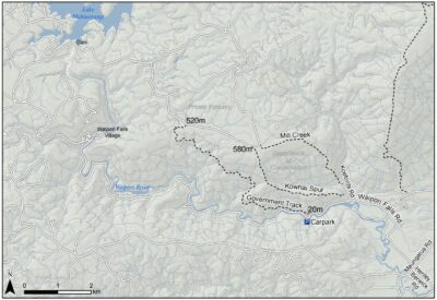
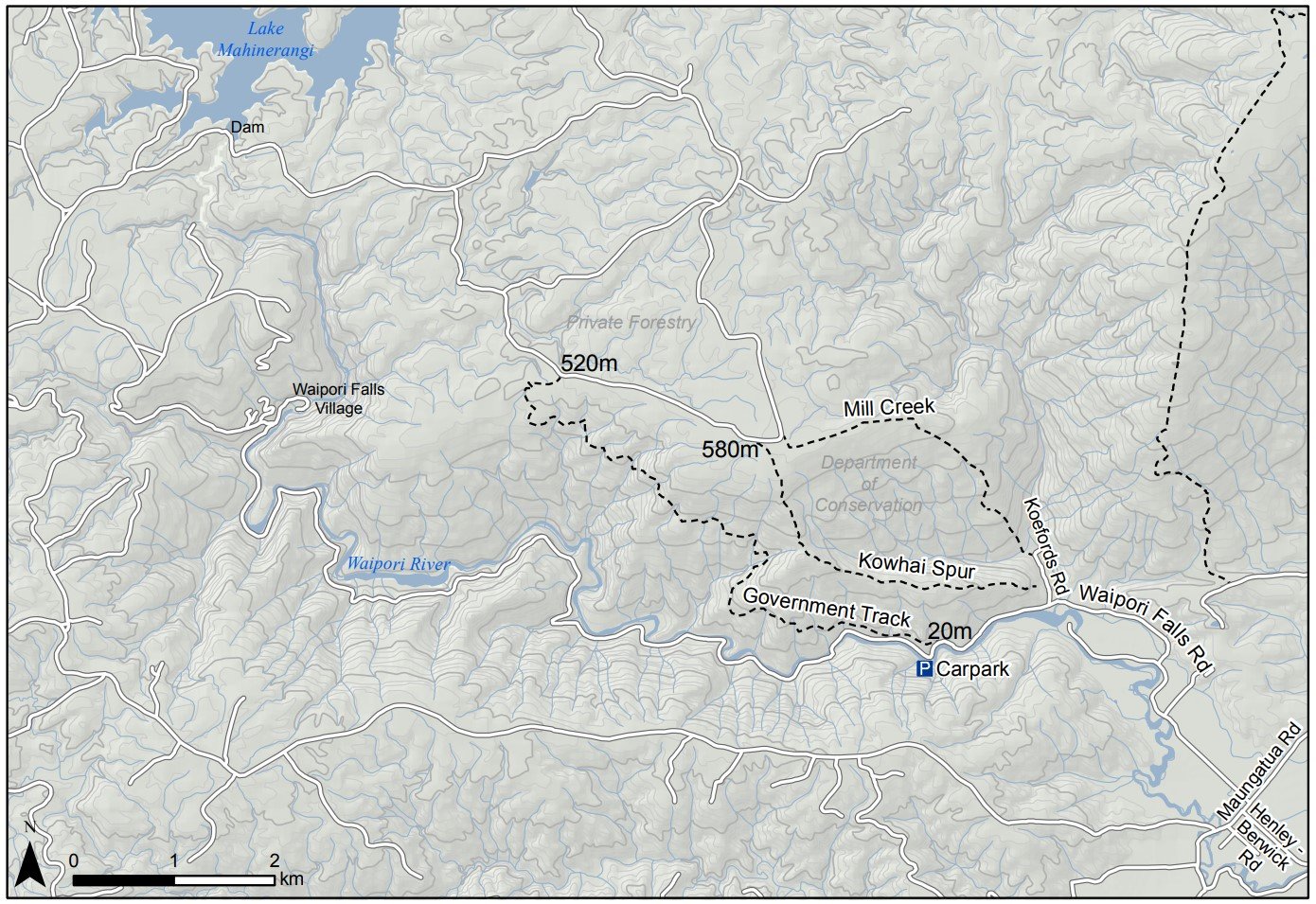
DCC – Government Track map – see image below.
DCC: Mountain biking on Government Track
[DCC brochure extract: Government Track. 4 hr 30 min, 17 km (return).

The track entrance is Government Track / Kowhai Spur 5 km down Waipori Falls Rd on the right; parking is 100 m further on the left.
Traversing the slopes of the beech-and mānuka-forested Waipori Valley south of Dunedin, the Government Track was built in the 1860s to provide access to the central goldfields. For mountain bikers there is an option of riding up and returning the same way. Alternatively, once at the top follow the pylon track left and steeply down into Waipori township, then follow the road back to the start.

TRTC Grading Information – trips incorporating these tracks are generally given a TRTC grading of  4. This is indicative only, as trips can be allocated a higher or lesser grading depending on the route taken. For more detailed analysis refer to Grading Information.

How To Get There:

Option 1 – drive to Outram from PJP and turn left onto Formby Street , then right onto Huntly Road. Continue on this road onto Maungatua Road and turn right onto Waipoai Falls Road and follow road to reserve carpark located in the gorge.

Option 2  – drive south on SH1 to the Berwick turnoff and follow Henley Berwick Road to Berwick, turn right then left onto Waipori Falls Road and follow road to the reserve carpark located in the gorge.

Links to tramps and hikes in the same area:

24/09/2025. Government Track Circuit. Grade 4.5. Trampers.  Leaders: John Gardiner and Carolyn Pridham
10/07/2024. Government Track, Kowhai Spur. Grade 4. Trampers. Leaders: Lyn Keene, Jenny Wilton.

Government Track and Beyond (1991 – 2023. 34 trips)
Post Office Creek – Government Track (1996 – no report – downhill all the way.)
Mill Creek Track and Kowhai Spur  (1993 – 2010, 13 trips – only 1 report).
Tramps Incorporating Three Kings (1989 – 2021, 26 trips including 4 to Mill Creek, Kowhai Spur, or both (no reports)).

DCC – Government Track map:
Gvt Track Kowhai Spur Map Dcc Screenshot 2024 07 08 221526