
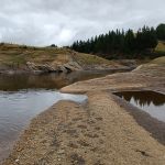
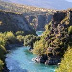
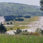
 19/03/2025. Post Office Creek via Reid Farm. Grade 3.5. Hikers. Leaders: Bruce Spittle and Dave Roberts.
After leaving Peter Johnston Park at 0900, seven cars regrouped and collected more passengers at Traquair Junction before 30 hardy outdoor enthusiasts proceeded in convey about 11 km down Mahinerangi Road to park near the woolshed about 500 m past the entrance to Verterburn Station at Rapid Number 1013. Continue reading “Post Office Creek via Reid Farm”
Category: Hikers
Queenstown Camp 2025
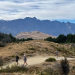 09/03/2025 to 14/03/2025 . Queenstown Camp (Kelvin Heights)
Sunday 9th March 2025 travel to Lakeland Park Christian Camp on Kelvin Heights Peninsula.
Queenstown Camp 2025 Day 1: Queenstown Hill, Wilson’s Bay, Bobs Cove
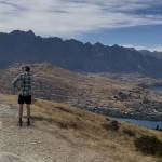 09/03/2025 to 14/03/2025 . Queenstown Camp. Queenstown Hill, Wilsons Bay, Bobs Cove. Trampers, and Hikers. Leaders: Anne and Rod Ward, Di and Chris Bezett.
Continue reading “Queenstown Camp 2025 Day 1: Queenstown Hill, Wilson’s Bay, Bobs Cove”
Queenstown Camp 2025 Day 3: Mt Crichton Loop, Sawpit Gully, German Hill, Bush Creek.
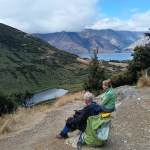 09/03/2025 to 14/03/2025 . Queenstown Camp – Mt Crichton Loop, Sawpit Gully, German Hill, Bush Creek. Trampers & Hikers. Leaders: Anne and Rod Ward, Di and Chris Bezett.
Queenstown Camp 2025 Day 4: Wye Creek, Kawarau Bike Trail, Gibbston Tavern.
 09/03/2025 to 14/03/2025 . Queenstown Camp. – Wye Creek, Kawarau Bike Trail, Gibbston Tavern. Trampers, and Hikers. Leaders: Anne and Rod Ward, Di and Chris Bezett.
Continue reading “Queenstown Camp 2025 Day 4: Wye Creek, Kawarau Bike Trail, Gibbston Tavern.”
Gardens, Pine Hill Return
 26/02/2025. Gardens, Pine Hill Return. Grade 2. Hikers. Leaders: Jenny Finnerty, Kay Seddon.
8.40 and only me in the carpark? I thought everyone had gone with the trampers. Luckily, I managed to scrounge up another 6 plus met up with another 5 in town
Moores Bush and Sullivans Dam
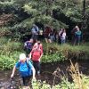 19/02/2025. Moores Bush & Sullivan Dam. Grade 2.5. Hikers. Leaders: Pam Clough, Jay Devlin.
Moores Bush Reserve. Hikers left PJ Park and travelled over Three Mile Hill, Wakari Road, Tanner Road, Malvern Street, Leith valley Road to end at Thompson Road to the beginning of the Moores Bush Reserve. Continue reading “Moores Bush and Sullivans Dam”
Mt Cargill / Forrester Park
 12/02/2025. Mt Cargill / Forrester Park Grade 3. Hikers. Leaders: Bill Cubitt and Peter Beal.
The best laid plans of mice and men! We discovered late in the piece that most of the Mt Cargill track was closed for maintenance.
Harwood Area
 29/01/2025. Harwood Area. Grade 2. Hikers. Leaders: Raewyn Keene and Helen Morris.
The Web notice said, ‘hoping for a leisurely and enjoyable day’s outing in an eclectic spot’, and that’s what 20 hikers & 1 grand-daughter experienced.
Cedar Farm to Mt Cutten
 22/01/2025. Cedar Farm to Mt Cutten. Grade 3. Hikers. Leaders: Heather Reid, Val Cayford.
22 hikers left Peter Johnson Park at 9am in brilliant sunshine and the promise of a lovely day. Continue reading “Cedar Farm to Mt Cutten “
Moeraki Millennium Track Moeraki Township to Moeraki Boulders
15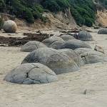 /01/2025. Moeraki Millennium Track Moeraki Township to Moeraki Boulders. Grade 2.5. Hikers. Leaders: Neville Griffiths and Dave Roberts.
A group of 13 hikers in 4 cars made the trip to Moeraki and met up at the car park adjacent to the public toilets in the Moeraki township.
Continue reading “Moeraki Millennium Track Moeraki Township to Moeraki Boulders”
Cleghorn St to Signal Hill Monument
 04/12/2024. Cleghorn Street to Signal Hill Monument . Grade 3. Hikers. Leaders: Maria McNee and Peter Dodds.
Only 3 cars left from Peter Johnston car park on what was promising to be a sweltering day.
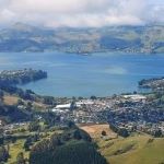
Around Harbour Cone
 27/11/2024. Around Harbour Cone. Grade 3. Hikers (and Trampers). Leaders: Jenny Flack and Rhonda Wilson.
Listening to the heavy rain coming down on Tuesday night I don’t think too many of us thought we would be out hiking the next day. Continue reading “Around Harbour Cone”
Orokonui / Wrights Road
 20/11/2024. Orokonui / Wrights Road. Grade 3. Hikers. Leaders: Jay Devlin and Pam Clough.
On 20/11/24 21 hikers gathered at the Orokonui Sanctuary carpark.
Outram Glen to Lee Stream
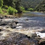 13/11/2024 Outram Glen to Lee Stream. Grade 2. Hikers. Leaders: Julie McKenzie & Katrina McKenzie.
On a cloudless morning 25 happy hikers met at the Outram Glen carpark.