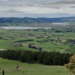
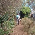
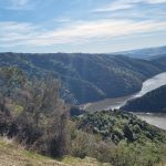
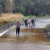
 30/10/2024. 3 Kings from Heenan Road. Grade 3 Hikers. Leaders Dave Roberts Neville Griffiths.
On a chilly calm Morning 18 hikers set off from Mosgiel at 9am to pick up one hiker at Outram
Taieri Recreational Tramping Club
Mid-week recreational and social walking group based in Mosgiel NZ

30/10/2024. 3 Kings from Heenan Road. Grade 3 Hikers. Leaders Dave Roberts Neville Griffiths.
On a chilly calm Morning 18 hikers set off from Mosgiel at 9am to pick up one hiker at Outram
 23/10/2024. Flagstaff, Bull Ring. Grade 2.5. Hikers. Leaders: Theresa White, Julie MacKenzie.
19 hikers left P/J car park with a warning of 23 degrees, so take plenty of water. Fortunately for us there was a breeze that got stronger, and the heat was manageable. Continue reading “Flagstaff, Bull Ring”
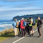
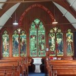 16/10/2024. Warrington, Seacliff. Grade 2. Hikers. Leaders: Maria MacNee, Julie MacKenzie..
23 hikers, travelling in 7 vehicles, converged in the car park at the picturesque St Barnabas church on the Coast Rd Warrington Continue reading “Warrington, Seacliff”
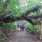 09/10/2024. Fraser’s Gully. Grade 2.5. Hikers. Leaders Helen Morris and Heather Reid.
18 hardy souls left the PJ carpark for Frasers Gully car park on a damp morning. No rain in town. Walked up so far and stopped for our morning tea on a corner. Then carried on up to the top at Dalziels Road. Continue reading “Fraser’s Gully”
 25/09/2024. Wakari / Kaikorai Loop. Grade 1.5. Hikers Leaders: Jenny Finnerty and Ady Whitson
Eventually 16 of us gathered at the meeting place and walked several metres along Wakari Road to the Bain Reserve
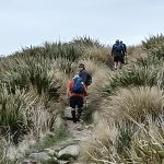
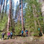 18/09/2024. Three Mile Hill Forest. Grade 3. Hikers. Leaders: Bruce Spittle & Bill Cubitt.
Thirty-two outdoor enthusiasts, including Dave and Peter coming for their first hikes, assembled on the Taieri Lookout carpark a day or so after snow had covered nearby hills. Continue reading “Three Mile Hill Forest”
 11/09/2024. Big Stone Road. Grade 3. Hikers. Leaders: Bill Cubitt & Adrienne Ensor.
On a beautiful spring morning 20 keen walkers started out from the lay-bay opposite the entrance to Daphne Road to commence their adventure through, what is known as the Allanton Block of Wenita Forest.
 28/08/2024. Botanic Garden, Chingford Park Grade 3. Hikers. Leaders :Dave Roberts, Vivienne Manning
On a brilliant sunny Dunedin Morning 19 hikers met at the Dunedin Botanic Garden top carpark.
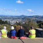 21/08/2024. Big Easy. Grade 2.5. Hikers. Leaders: Pam Clough, Jay Devlin.
Wed 21st August saw 17 eager hikers meet at the carpark behind Logan Park High to follow the Big Easy mountain bike / walking up only trail to the monument 327 m above sl.
Continue reading “Big Easy”
 14/08/2024. Taieri Mouth Excursion. Grade 3. Hikers. Leaders: Bill Cubitt & Alex Griffin.
26 hikers gathered at Knarston Park on a beautiful late winter’s morning.
Continue reading “Taieri Mouth Excursion”
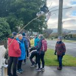 31/07/2024 Mosgiel Ramble. Grade 2. Hikers. Leaders: Ady Whiston, Jenny Finnerty
With the weather the way it was Jenny decided for a walk around Mosgiel (good decision).
Continue reading “Mosgiel Ramble”
 24/07/2024. Delights of St Clair. Grade 1.5. Hikers. Leaders: Neville Griffiths, Wyn Davies.
After parking our cars and meeting up with the Taieri Hikers in Moana Rua Road, 20 Hikers headed off just after 10am and walked across the Kettle Park Sports field towards Marlow Park.
Continue reading “Delights of St Clair”
 17/07/2024. Hikers. Concord Creations Grade 2. Leaders: Jan Butcher. & Jenny Finnerty.
Just 6 hikers met up at PJ Park & travelled to Emerson Street, Concord to meet up with 7 town folk.
Continue reading “Concord Creations”
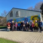
 10/07/2024. Street Art Trail and Surrounds, Grade 1.5. Hikers. Leaders: Wendy Langley, Val Cayford.
24 of us began our mural art journey walking from the Southern Cemetery, into town to view and learn about the many murals and their artists, around our city centre. Continue reading “Street Art Trail and Surrounds”
 26/06/2024. Whare Flat. Hikers. Grade 2.5. 11km. Leaders: Bruce Spittle, Adrienne Ensor.
Sixteen hikers assembled at 0950 after parking on the side of the Silverstream Valley Road near the McKerrow Bridge Fields near the end of the tar sealed part of the road, 3.74 km along the road. Continue reading “Whare Flat, Waiora, Schoolhouse, Tunnels Track, McRaes Weir, Racemans”