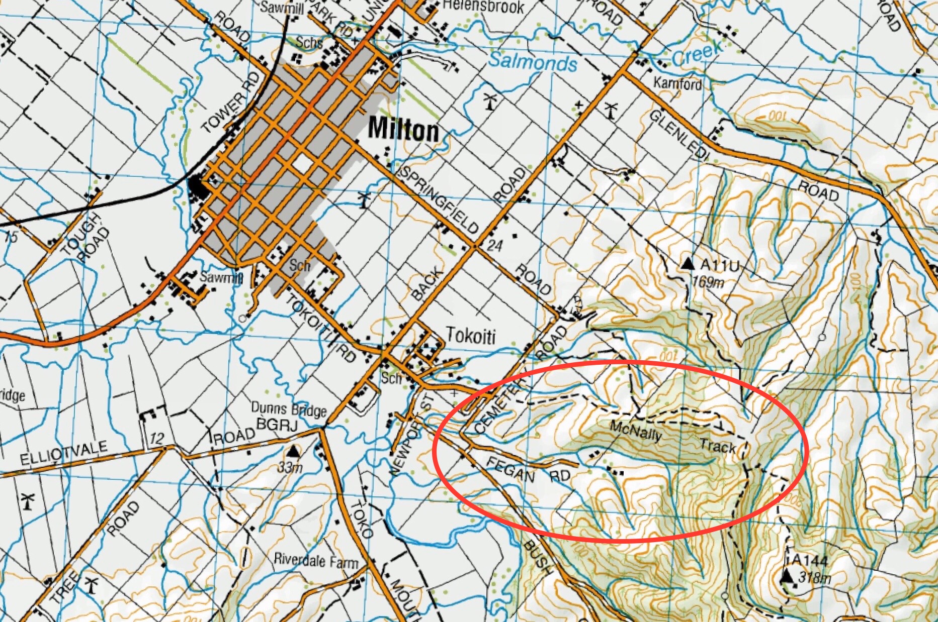
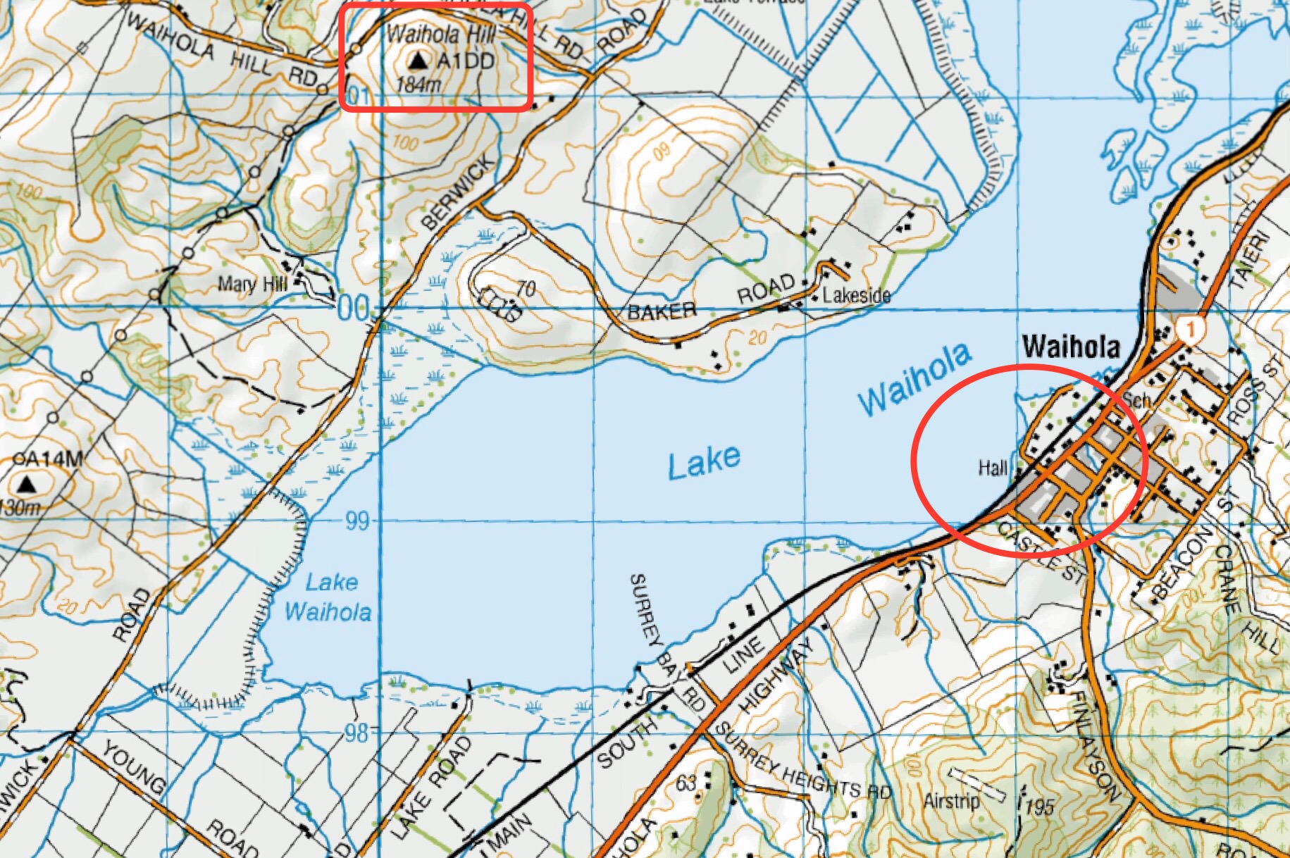
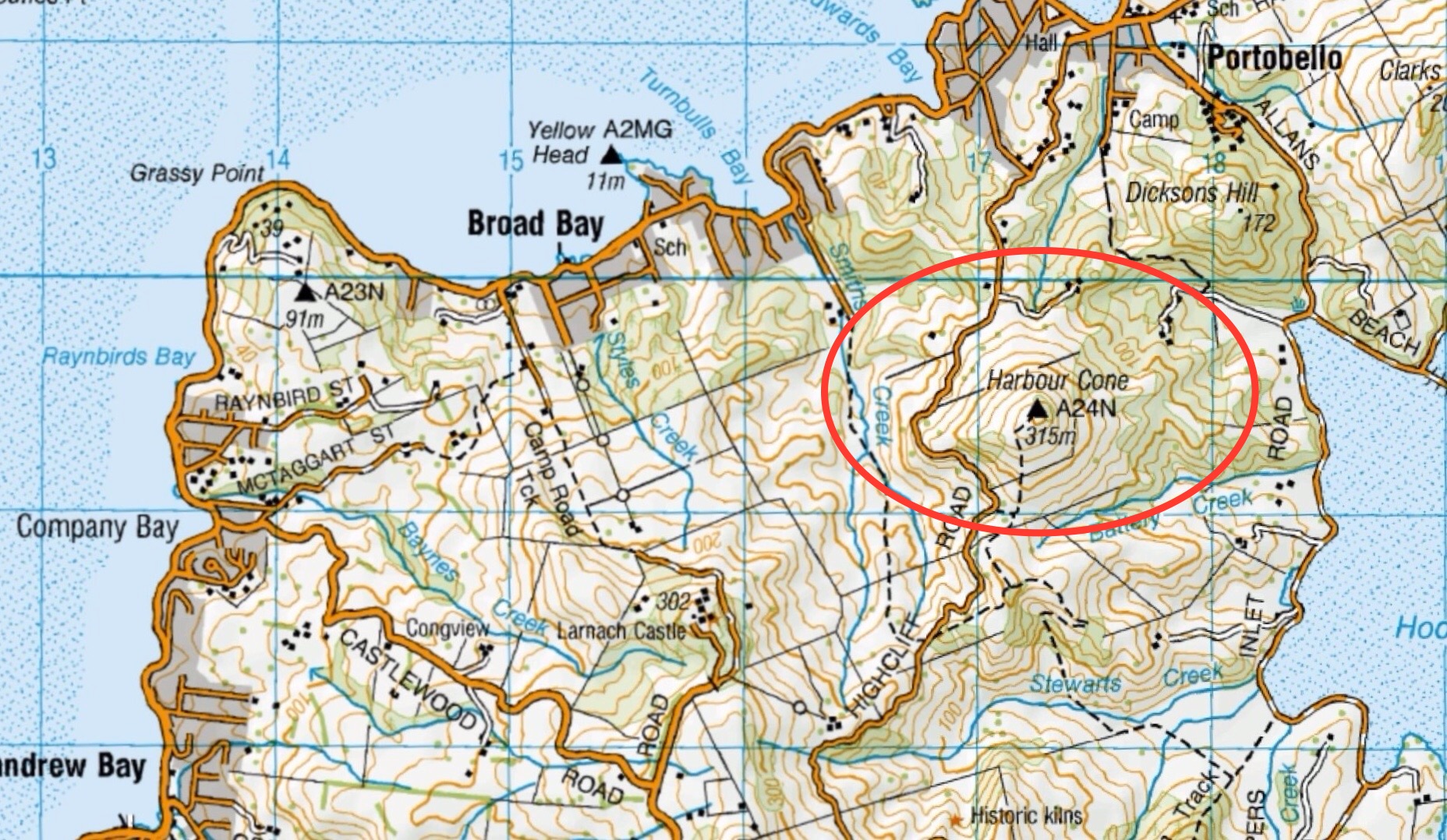
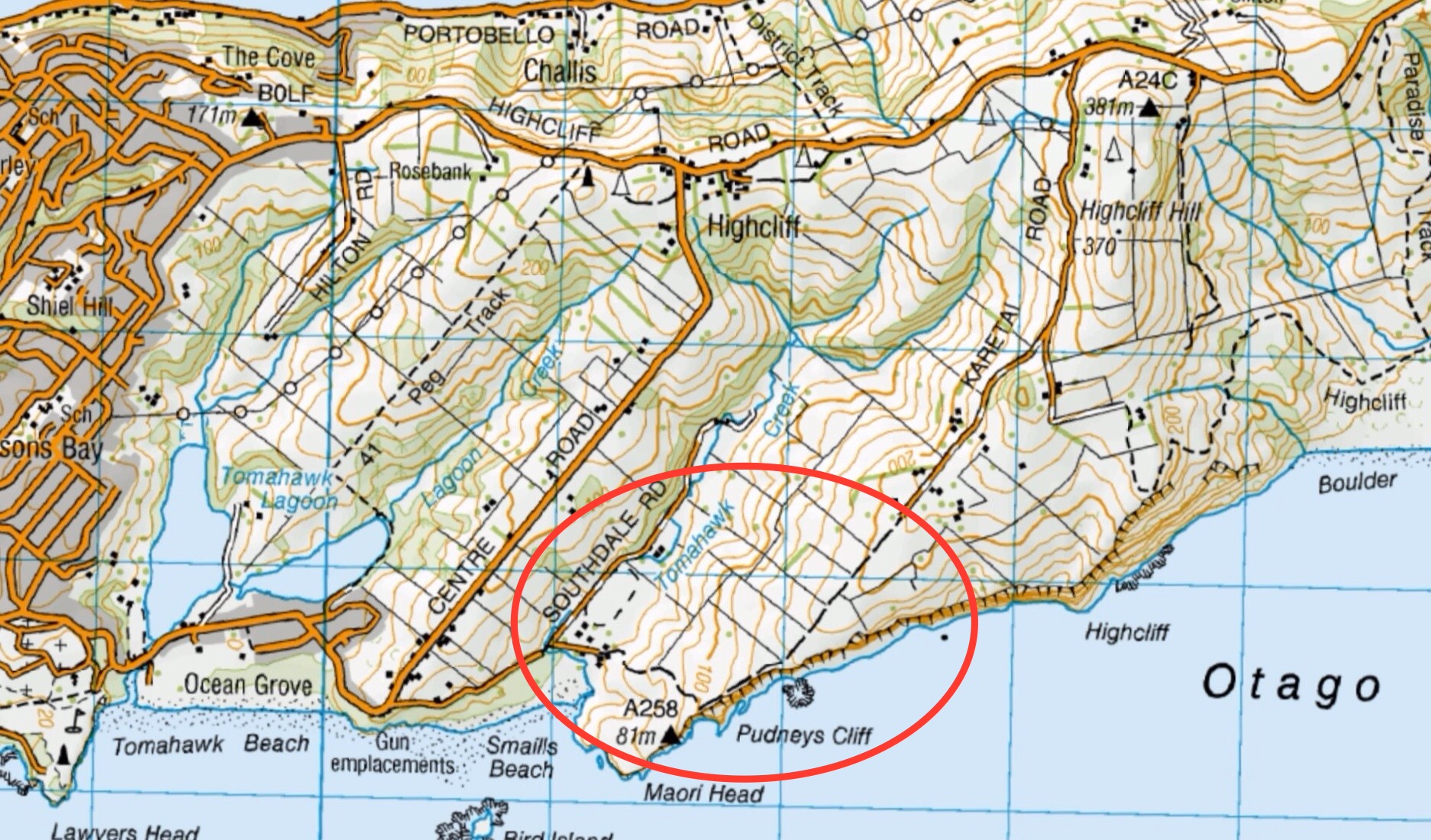
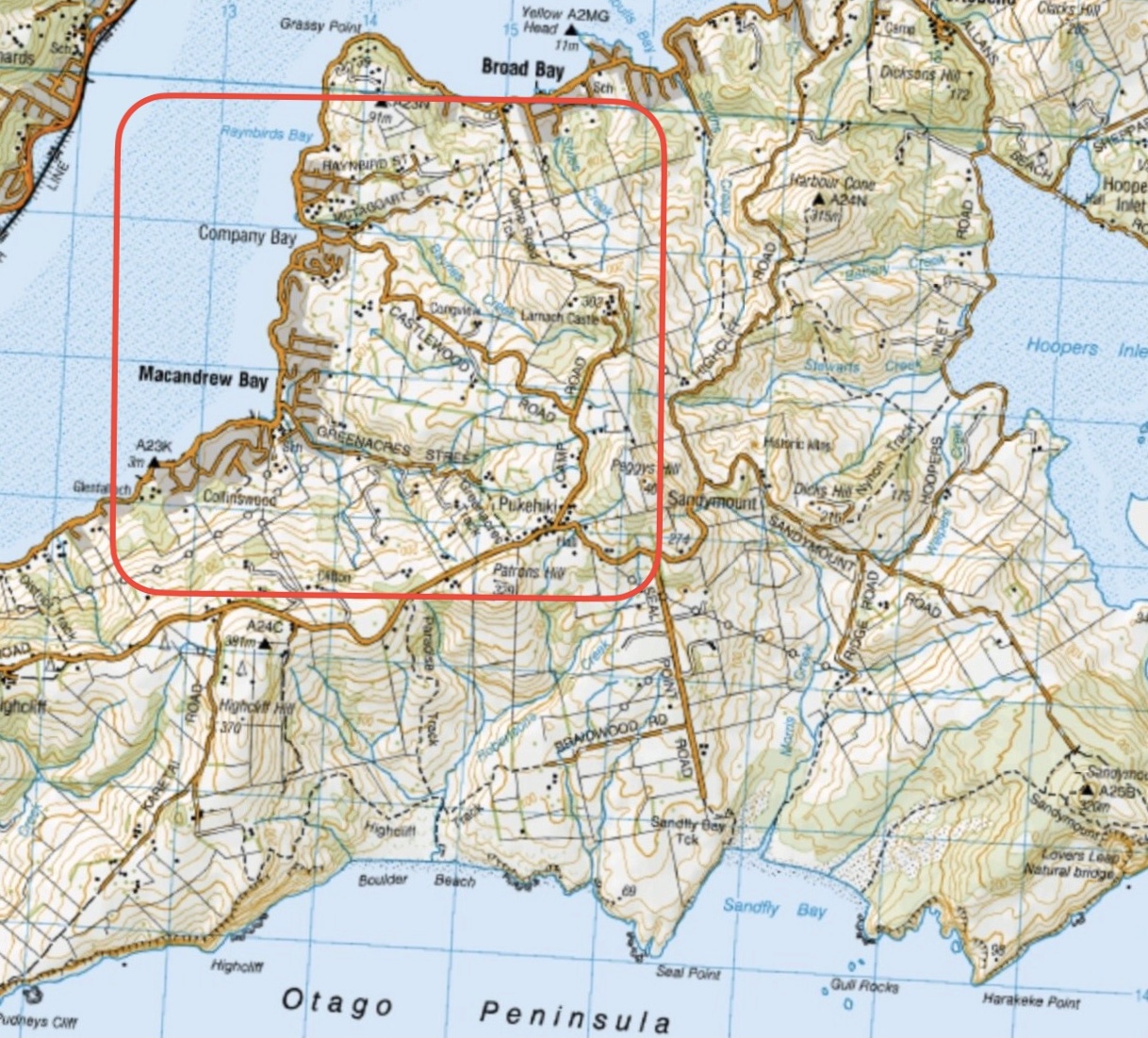
Harwood – Information and Trips Library

Scope:

This page of club tramps and hikes covers trips to the Otago Peninsula and involves trips to Harwood. (map)

Background Information:

Road distances from Mosgiel carpark.

Links to tramps and hikes in this area:

29/01/2025. Harwood Area. Grade 2. Hikers.  Leaders: Raewyn Keene and Helen Morris.

Harwood – End of year picnic. 2017 – 1998 (6 trips, 1 with reports and photos, 3 with photos only, 2 with no report or photos)


Akatore Area (inc. Coutts Farm / Gully, Taieri Mouth) – Information and Trips Library

Scope:

This page of club tramps and hikes in the South Coast area groups together trips to the Akatore Area including Coutts Farm / Gully, Sawmill Road and Taieri Mouth. (map)

Background Information:

Road distances from Mosgiel carpark.

Access Permissions are required for trips to Akatore and Coutts Farms – refer guidelines

Links to tramps and hikes in this area:

15/01/2025. Akatore Creek to Taieri Mouth. Trampers.  Leaders: Spen Walker and Jane Bruce.

Coutts Gully / Farm, Sawmill Road. 2024 – 1988 (23 trips, 10 with reports and photos, 1 with photos only, 1 with report only, 11 with not report or photos).
Akatore Farm Walk or Beach Walk. 2019 – 1991 (15 trips, 8 with reports and photos, 2 with photos only, 5 with no report or photos)
Akatore Forest: Narrowdale Rd, Gorge Hill, Stewarts Farm. 2023 – 1989 (11 trips, 2 with reports and photos, 1 with photo only, 8 with no report or photos)
Akatore Forest. 2016 – 1991 (8 trips, 4 with reports and photos, 4 with no reports or photos)


Takitakitoa Wetlands – Information and Trips Library

Scope:

This page of club tramps and hikes in the South Coast area groups together trips to the Takitakitoa Wetlands Reserve. (map)

Background Information:

Road distances from Mosgiel carpark.

https://www.fishandgame.org.nz/game-bird-hunting-in-new-zealand/where-to-hunt/regional-info/otago/takitakitoa-wetland/

https://www.southroads.co.nz/projects/takitakitoa-wetland-restoration-project

How To Get There:

The Takitakitoa Wetlands is located about 40 minutes drive south of Dunedin and is at the end of Takitakitoa Road off Otokia-Kuri Bush Road.

Links to tramps and hikes in this area:

11/12/2024. Takitakitoa, Wetland, Waihola Hall. Combined hike and Christmas Lunch.  Leaders: Jan Butcher, Wendy Langley, John Gardiner, Graeme Souter.

7/4/2021. Takitakitoa Wetland/Lester Harveys 90th Birthday. All. Leaders. Raewyn, Phil and Jill D


Powder Ridge – Information and Trips Library

Scope:

This page of club tramps and hikes in the Whare Flat area  groups together trips to Powder Ridge (map)

Background Information:

Road distances from Mosgiel carpark.
Silver Peaks Forest for background information on the nearby area. DCC land.
Powder Ridge Maintained by Green Hut Track Group.

How To Get There:

Powder Ridge track runs between Racemans and Long Ridge Tracks. It is best accessed from Racemans Track approximately 30 -40 minutes from the Whare Flat carpark along the Silverstream Valley Road off Dukes Road North (just before Three Mile Hill)

Links to tramps and hikes in this area:

12/02/2025. Powder Ridge to Long Ridge (return). Grade 5. Leaders: Pam Cocks, Esther Willis.

Powder Ridge tramps. 2021 – 1991 (13 trips, 6 with reports and photos, 1 with photos only, 6 with no reports or photos)


Craiglowan Falls – Information and Trips Library

Scope:

This page of club tramps and hikes in the area of Whare Flat groups together trips to the Craiglowan Falls

Background Information:

Road distances from Mosgiel carpark.

Links to tramps and hikes in this area:

Craiglowan Falls. 2018 – 1997 (9 trips, 4 with reports and photos, 1 with photos only, 4 with no reports or photos)

Orokanui Ecosanctuary – Information and Trips Library

Scope:

This page of club tramps and hikes to the West Harbour area groups together trips to the Orokanui Ecosanctuary. (map)

Background Information:

Road distances from Mosgiel carpark.

Links to tramps and hikes in this area:

20/11/2024. Orokonui / Wrights Road. Hikers.  Leaders: Jay Devlin and Pam Clough.

Orokonui Ecosanctuary. 2012 – 1996 (9 trips, 1 with reports and photos, 1 with photos only, 7 with no reports or photos)


Moeraki – Information and Trips Library

Scope:

This page of club tramps and hikes covers trips on the North Coast north of Dunedin City, Waitati involving club trips to Moeraki township  / boulders. (map)

Background Information:

Road distances from Mosgiel carpark.

Links to tramps and hikes in this area:

15/01/2025. Moeraki Millennium Track Moeraki Township to Moeraki Boulders. Hikers.  Leaders: Neville Griffiths and Dave Roberts

Moeraki. 2022 – 1989 (5 trips, 20 with reports and photos, 1 with photos only – 15/12/1997 TRTC 10th Anniversary Dinner, 2 with no reports or photos)
End of Year: Moeraki Boulders. 1997 – 1989 (3 trips, no reports or photos)
Camp: Moeraki Motor Camp. 1992 – 1989 (2 trips, no reports or photos)


Waihola Area – Information and Trips Library Post

Scope:

This page of club tramps and hikes in the area South via SH1 and groups together trips to the area around Lake Waihola, including Waihola Hill and Lawlor Farm. (map)

Background Information:

Road distances from Mosgiel carpark.

Access Permissions are required for trips incorporating Lawlor Farm – refer guidelines

Links to tramps and hikes in this area:

04/12/2024. Waihola – new cycleway/walk. Trampers.  Leaders: Heather Kirk and Jenny Wilton

Waihola Walk. 2024 – 2010. (4 trips, 3 with reports and photos, 1 with photos only)
Waihola Hill and Lawlor Farm. 2023 – 2022. (2 trips with reports and photos)
Finlayson, Wilkinson, Waihola, Skyline Roads. 2012 – 1988 (16 trips, 1 with report and photo, 1 with photos only, 14 no reports or photos)

Deep Creek – Information and Trips Library

Scope:

This page of club tramps and hikes in the area West via SH87 (inland on the south side of SH87) groups together trips to Deep Creek. (map)

Background Information:

Road distances from Mosgiel carpark.
Deep Creek Water Scheme Pipeline history.
Further background information behind Deep Stream project

Access Permissions are required for trips to Deep Creek – refer guidelines

How To Get There:

Follow State Highway 87 from Outram to the Clarks Junctions turn off. Turn left onto the Old Dunstan Road which will take you past Rocklands Station and continue to the gate of the Te Papanui Conservation Park (managed by DOC).

Links to tramps and hikes in this area:

06/11/2024. Deep Creek Weir. Combined.  Leaders: Barbara Shackell, Wendy Langley, Carolyn Pridham, Sue Johnstone.

Deep Creek Weir from Old Dunstan Road past Rocklands. 2023 – 1989 (19 trips, 8 with reports and photos, 9 with no reports, 2 with photos only)


Heenan Road to the Maungatuas and the Three Kings – Information and Trips Library

Scope:

This page of club tramps and hikes covers trips West via SH87 which includes trips from Heenan Road to the Maungatuas and the Three Kings. (map)

Background Information:

Road distances from Mosgiel carpark.

Access Permissions maybe required as this trip (Heenan Road) ventures over a working farm – refer guidelines

How To Get There:

From Outram turn left onto Allanton Road then right onto Huntly Road – this runs into Maungatua Road. Proceed to McLaren Road on the right, this in turn runs into Heenan Road.

Links to tramps and hikes in this area:

30/10/2024. 3 Kings from Heenan Road. Hikers. Leaders Dave Roberts Neville Griffiths.

Tramps Incorporating Three Kings. 2021 – 1989 (26 trips, 6 with reports, 1 with photos only, 19 with no reports)


Dunedin City Town Belt areas – Information and Trips Library

Scope:

This page of club tramps and hikes in the Dunedin Central City area groups together trips Town Belt and includes Bellknowes, Bullock Track, Cosy Dell, Olveston, Robin Hood Park, Unity Park.

Background Information:

Road distances from Mosgiel carpark.

There is a heap of info on Google if any one wants to find out about the town belt, Olveston, and any of the grounds like Robin Hood. Also the Dunedin Amenities Soc. have a wonderful web page as well.

Links to tramps and hikes in this area:

Street Walk: Town Belt areas. 2024 – 2008 (11 trips with reports and photos)


Yellow Ridge, The Gap, Gap Ridge – Information and Trips Library

Scope:

This page of club tramps and hikes in the Silver Peaks area groups together trips to Yellow Ridge (map) including Gap Ridge, The Gap, Yellow Hut and the South Branch of the Waikouati River

Background Information:

Road distances from Mosgiel carpark.

TRTC Grading Information – trips to Yellow Ridge, The Gap etc are generally given a TRTC grading of 5. This is indicative only, as depending on the route taken, allocation of gradings can differ from this. For more detailed analysis refer to Grading Information.

Silver Peaks Forest for background information on the area.
Accessed from Mountain Road from old forest HQ 6 hr ret, Route, DOC and private land.

How To Get There:

Proceed via the Northern motorway to Waitati and turn left onto Double Hill Road (just past the store on the left at the end of the motorway), which joins Steep Hill Road. Access to Yellow Ridge route is located off this road.

Links to tramps and hikes in this area:

19/03/2025. Yellow Ridge via Walkers Road, River Track/out via Tunnel Track. Grade 5. Trampers. Leader: Ross Davies.

Tunnels Track, Yellow Hut, The Gap, Gap Ridge. 2021 -1997 (8 trips, 6 with reports and photos, 2 with no reports)


Bull Creek, Quion Point – Information and Trips Library

Scope:

This page of club tramps and hikes in the South Coast area groups together trips to Bull Creek and Quion Point. (map)

Background Information:

Road distances from Mosgiel carpark.

“quoin” definition:
1. An exterior angle of a wall or other piece of masonry.
2. Any of the stones used in forming such an angle, often being of large size and dressed or arranged so as to form a decorative contrast with the adjoining walls.
Seek permissions. Coast and farm walk. Bull Creek nature walk to waterfall (tiny!) recommended.
Links to tramps and hikes in this area:

Quoin Point Bull Creek. 2023 – 1996. (16 trips, 7 with reports, 1 with photos only, 8 with no reports or photos)


Inch Clutha, Kaitangata – Information and Trips Library

Scope:

This page of club tramps and hikes in the South Coast area groups together trips to Kaitangata and Inch Clutha (map)

Background Information:

Road distances from Mosgiel carpark.

Links to tramps and hikes in this area:

02/04/2025. Inch Clutha. Grade 2.5. Combined. Leaders: Phil Keene, Graeme Souter, Bruce & Jenny Wright.

Kaitangata. 2003 – 1992 (3 trips. 1 trip (14/9/2023) as guests of Trixie Trampers (Blaclutha) with report and photos)


Three Mile Hill Forestry Tracks – Information and Trips Library

Scope:

This page of club tramps and hikes in the area of Whare Flat groups together trips to the Three Mile Hill Forestry Tracks.

Background Information:

Road distances from Mosgiel carpark.

Permission is required – see Three Mile Hill walking track 2001 link below

Links to tramps and hikes in this area:

18/09/2024.  Three Mile Hill Forest. Hikers.  Leaders: Bruce Spittle & Bill Cubitt.


Three Mile Hill walking track. 2001 (1 trip no report)