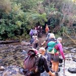
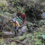
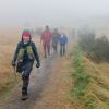
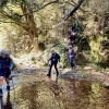
18/09/2024 Raingauge Ridge – Steve Amies Grade 4.5. Trampers. Leaders: Neil Hodgkin and Sarah McCormack.
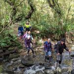 As I write this, I can’t help thinking that yesterday we were so lucky with the weather.
Taieri Recreational Tramping Club
Mid-week recreational and social walking group based in Mosgiel NZ

18/09/2024 Raingauge Ridge – Steve Amies Grade 4.5. Trampers. Leaders: Neil Hodgkin and Sarah McCormack.
As I write this, I can’t help thinking that yesterday we were so lucky with the weather.
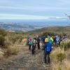
 11/09/2024. McNally Walkway. Grade 3. Trampers. Leaders: Graeme Souter & Theresa White.
A lovely morning greeted us at the car park where 20 keen trampers departed for Milton and the McNally (yes, its McNally not McNally’s as I was advised) Walkway.
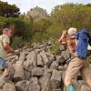
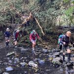 28/08/2024. Ross Creek and Davies Track. Grade 4. Trampers. Leaders: Ross Davies and Sarah McCormack.
There was a throng of people in Malvern Street in Woodhaugh by the time the leader arrived. It was a sunny and calm morning, and the throng numbered exactly 27 keen people. Interestingly, as the day wore on, the number diminished, but always exactly
Continue reading “Ross Creek and Davies Track”
 21/08/2024 . Street Art Walk Grade 1.5. Trampers Leaders: Wendy Langley,Val Cayford.
17 of us began our mural art journey on a beautiful sunny and warm day.
Continue reading “Street Art Walk.”
 14/08/2024. Tunnel Gully, McRaes, Racemans, Powder Creek Detour. Grade 3. Trampers. Leaders: Phil Keene & Gary Mort.
27 trampers in 6 cars all managed to end up at the Tunnel Gully entrance at the same time and after arranging for two cars to be parked at the main Silverstream car park we all set off just after 10.00am.
Continue reading “Tunnel Gully, McRaes, Racemans, Powder Creek Detour”
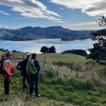
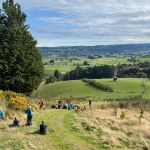
24/07/2024. Macandrew Bay, Company Bay, McTaggart St, Camp Road, Pukehiki, Greenacres Street. Grade 3. Trampers, Leaders: Yan Campbell, Jenny Flack.
It was a spectacular Dunedin morning, bright, sunny and calm. 26 of us set off from the playground in Macandrew Bay. We began by walking through the streets above the main road towards Company Bay and ended up on a path that drops down through Jenny’s pleasant, terraced property Continue reading “Macandrew Bay, Company Bay, McTaggart St, Camp Road, Pukehiki, Greenacres Street”
 24/07/2024. Millennium Track return, Henley Start. Trampers. Grade 4 Leaders: Gwenda Farqharson. & Alison K.
Millennium – a strange name for a track? By definition. A period of one thousand years, especially one which begins and ends in “000”. Continue reading “Millennium Track Return (from Henley)”
 10/07/2024. Government Track, Kowhai Spur. Grade 4. Trampers. Leaders: Lyn Keene, Jenny Wilton.
18 Trampers braved a frosty morning to walk the Government Track /Kowhai Spur. Continue reading “Government Track and Kowhai Spur”
 26/06/2024 2024. Trampers. Nicols Creek, Pineapple Track. Grade 4. Leaders: Wyn and Ross Davies.
The weather forecasts were not very encouraging. Nevertheless, 12 courageous trampers arrived at the meeting point at Booth Road Continue reading “Nicols Creek, Moon Track, Pepper Tree Track, Pineapple Track”
Bobby’s Head, near Palmerston. Also Puketapu.
 7. 19/6/2024 Bobby’s Head expand. Grade 2.5 Leaders Barbara Shackell and Dave Mellish
The weather report was not that exciting for the planned trip to the Bobbys Head area east of Palmerston.
Click Swampy ridge track for background information
 5. 12/06/2024. Smithys, McQuillans, Swampy Ridge Road and Swine Spur. Trampers. Grade 3.5. Leaders Esther and Gail.
Twenty-two hardy trampers met at PJ park, and headed to Rollinson Road where we parked. Continue reading “Rollinsons Rd Locked gate, Swinespur, Swampy Ridge, McQuilkans, Smithies”
Boulder Beach closed during yellow eyed penguin nesting 1 November – 28 February.
Distance from car-park: 24 km to Macandrew Bay, 27 to Highcliff Road.
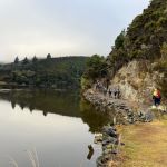
18. 22/05/2024 . Trampers. Macandrew Bay to Boulder Beach and return. Leaders Pam and Gwenda
With overcast skies 23 trampers headed up Greenacres Track (From Macandrew Bay) to Boulder Beach. Continue reading “Boulder Beach”
2. 15 May 2024. Trampers. Mountain Road/ South Waikouaiti River. Grade 4. Leaders: Graham Thurlow and John Gardiner
 Sometimes my grandmother would say something to me, and I’d ask,
“How do you know that?”
She used to say,
“A wee birdie told me.”
This report is a ‘wee birdie’ (a Fantail) told me tale: –
 18. 24/04/2024. Hikers. Graham’s Bush/Organ Pipes. Grade 3. 27 km. Leaders: Maria MacNee/Theresa White
A twenty-one strong group of hikers met at the rendezvous in Sawyer’s Bay at the Emmanuel Church Car Park. Continue reading “Grahams Bush, Old Main Rd, Organ Pipes, Buttars Peak, Mt Cargill, Mt Cutten”
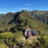 9. 17 /4/2024. Trampers Rosella Ridge. Grade 5.5 Leaders: Ross and Neil