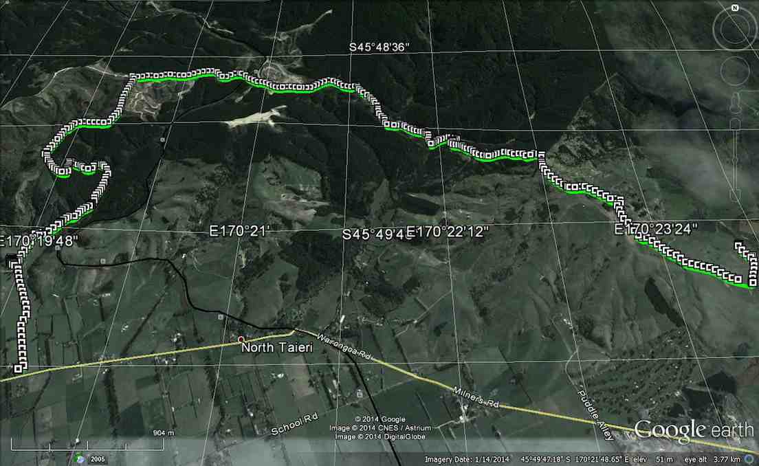
No. 90 on old hardcopy list of 113 club tramps. “Round Hill – Milburn (George) Farm”
42 km from car park.
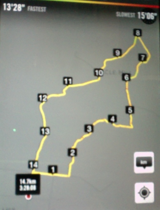
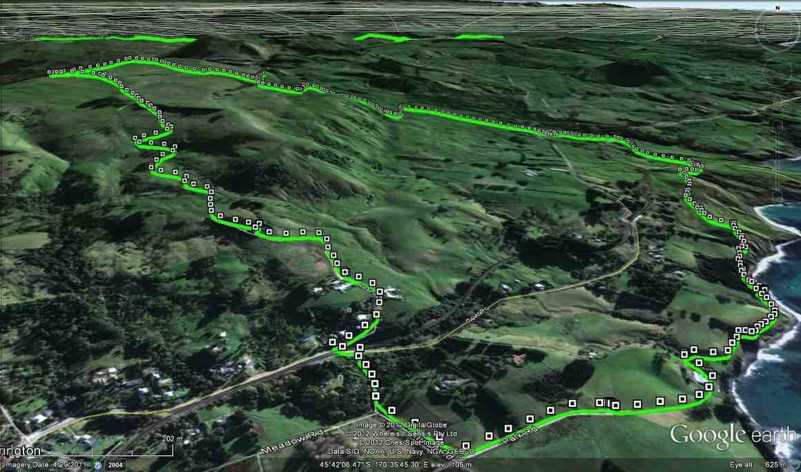
2/6/2014 Both. Fort Hill, Barnes and Circle Hill Roads, Milburn. Moderate. Leaders: Ian, Ken
iPhone GPS of route. Shows shorter than actual because I forgot to turn it on until after the first half km! See also Ken’s GPS for his 2010 route map.
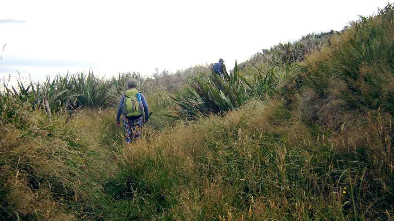
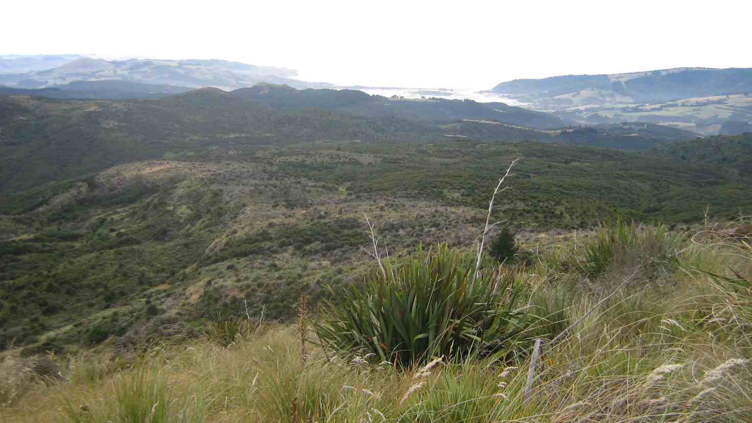
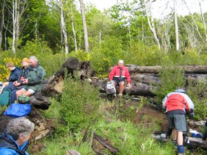
Twenty-six turned out for a sunny first tramp for the winter, on back country roads amongst lovely rolling hill farms to the west of Milburn.
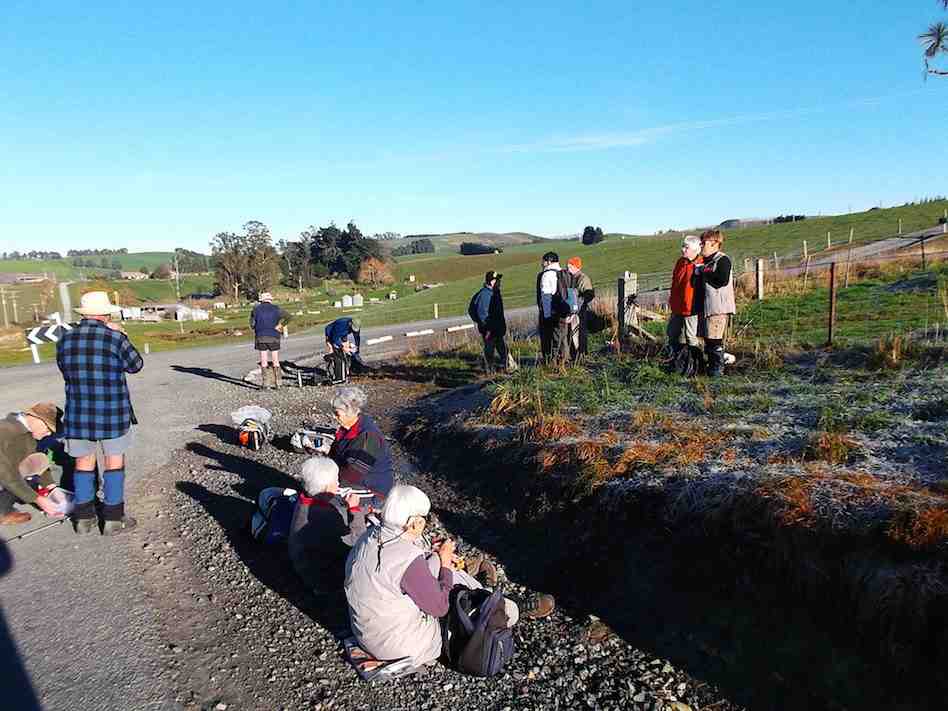
Morning Tea at the Finch Road turnoff from Circle Hill Road. (Heb pic)
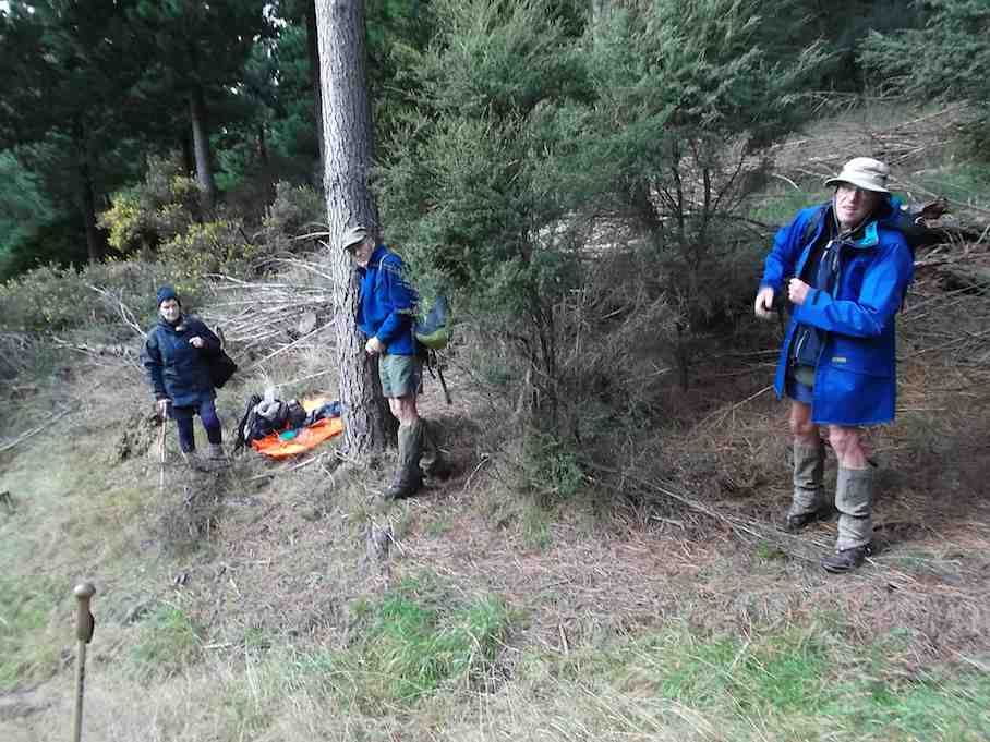
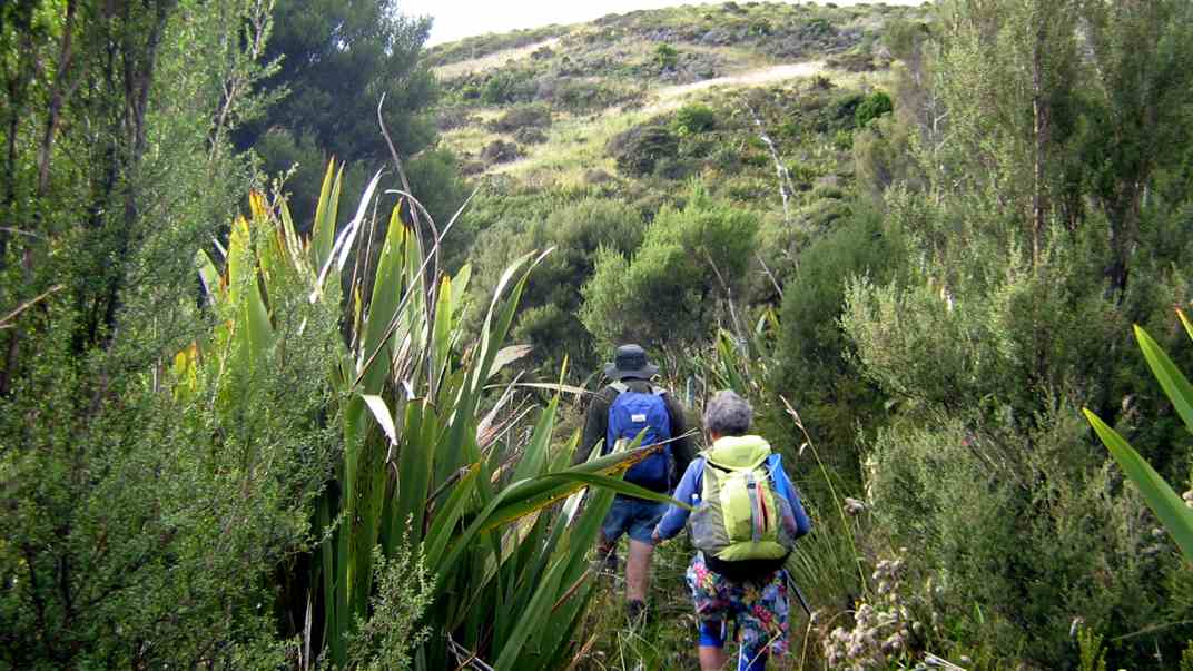
We lunched where Fort Hill Road ended at a T-junction with Barnes Road, which stretched left to meet Circle Hill Road, and right to form to form a larger route to also turn down Circle Hill Road at its end where both these roads joined to form Douglas Road.
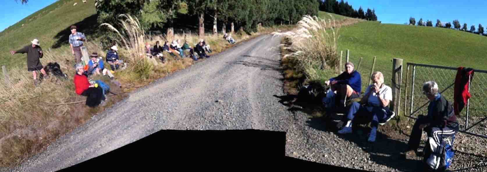
Panorama pic. (The black bit at pic bottom results from my inexpert handing of my panoramic app.) Lunch. Here, Barnes Road goes ahead (in the pic) for the shortcut route and to the right for the longer route.
Ken supplied this report regarding this spot. Thanks Ken. : “The people that did the longer walk, covered 15.2km; Moving time 3hrs 9min; We climbed 374mtrs. I guess the ones that took the shortcut walked about 11km.
I base this on the time taken for us to walk around the longer loop, & the ave speed was 4.8km/hr, & it took us nearly an hour to walk around the loop.”
As said before, the day was sunny and calm, and each ample time to make the climbing bits at bits own pace.
Just a personal thought for road walks. With the growing practice of wearing, and of availability of high-viz vests, a good idea would be for more than just the leaders to be wearing them.
And lastly. What is becoming the customary coffee stop was enjoyed this time at Waihola’s Black Swan. – Ian.
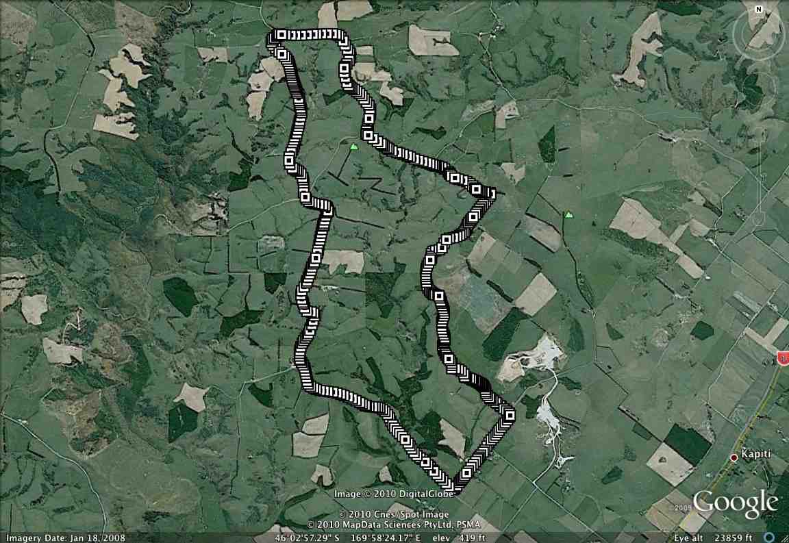
1/9/2010 Both. Fort Hill, Barnes and Circle Hill Roads, Milburn. Moderate. Leaders: Ian, Ken
GPS of route. The short-cut can be readily picked out. (Courtesy, Ken).
21/5/2014.Trampers: Nth Taieri Church, logging site, Mill Stream Rd, Silver Stream Rd. Car Shuttle. M
GPS of route, courtesy Ken. We walked 12.6km; 4.1 km/hr; Climbed 595mtrs; Max elev 447mtrs.
4 intrepid trampers turned up to do a walk that had never been done before by the club. The weather was not looking good, but we set off to leave one car at the Silverstream end, then came back to the Nth. Taieri Church, and walked up the muddy paddock to the restored cottage, where we had an early morning tea break. After this we walked up the track along the valley, which we found to be quite difficult due to fallen bushes across the track. Once into the pine forest the going was a lot clearer, but much steeper, & we worked up a bit of sweat climbing through here, so it was off with some clothing. When the top was reached at the farm paddocks, the wind was very brisk [& cold] so wind break clothing was quickly donned again. The walk along the farm road was uneventful, but when we reached the logging road we had to watch out for the trucks using it.
We walked past the log processing site, & into City forests, [which I forgot to get permission for], and then onto a little used road which lead us to the top of Mill Stream Rd. There was a lot of deer sign down here, but we didn’t see any deer. After crossing Mill Stream, it was a climb up the other side of the valley, where we stopped in the shelter of the trees for lunch, …
Packing up after lunch. (Heb pic, Ken caption)
… then up again through the back of Strauss’s property to the end of Mill Stream Rd. & onto the track leading down into Silverstream valley, back to the car which we had parked in the farmer’s yard earlier in the day.
The weather was good all day except for a short shower as we came down the track into Silverstream valley, although the wind was quite cold all day.
Everybody agreed it was a good walk, and that they would do it again. – Ken
On Tuesday March 25th Judy Knox and two friends of long-standing, Jan and Brian, set off for the Hollyford Valley. After a night at Te Anau we were at the road-end by midday on Wednesday, and had a leisurely three-hour walk to Hidden Falls Hut. Next morning Brian discovered he had left his heart pills in the car, so did a quick return for them, and we proceeded to Alabaster Hut, extending the day’s tramping, for him , to almost nine hours.
Still feeling fit, we covered the next, longer, leg, from Alabaster to Demon Falls Hut, in eight hours – a bit over the suggested time, but we always take regular (hourly) rests, and our pace is steady but not fast, considering heavyish packs. The track from the road-end to Alabaster is great – wide and well-formed, with gentle gradients. However, from here on it becomes seriously rough, and very up and down, making pretty hard going.
Now the fun begins. It’s Friday morning. We get an early start (first light) and set off in good heart. But Jan rapidly develops a pain in her right knee and gets slower and slower. We take numerous rests, lighten her pack, and watch anxiously. The ups and downs are endless, the three-wire bridges a real problem for her, and the map gives no indication of how far it is to the next hut – Hokuri, supposedly about eight hours from Demon Trail Hut.
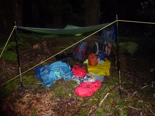
Daylight fades. We scramble on, now having to haul Jan over numerous obstacles. We have a look at her leg. The knee is badly swollen and barely takes her weight. Darkness falls. After thirteen hours tramping we call it a day, scramble off the waterfall of a track to a dry spot in the bush, and set up a fly camp. Lots of things to be thankful for. It’s fine and warm, and I am carrying my new poncho, which is large enough to open out into a fly, which we rig over a log and attach to our walking poles with bootlaces.
The bivvy camp (Judy pic and caption)
And we are carrying a locator beacon. Hot soup, and we settle for the night. Surprisingly we all sleep relatively well, in spite of the odd buzz of a mosquito and some light rain just before daylight. Hopefully the rest will help Jan’s knee and we can get to the hut in the morning.
No such luck. When she rolls out of her sleeping bag she can barely stand. We debate the options. Nothing for it but to set off the beacon, albeit reluctantly. We eat muesli and drink milo, then pack up and wait. Two hours later we hear the chopper approaching. It spirals down, and Brian and I frantically wave yellow pack liners until visual contact is made.
Looking up at the chopper (Judy pic and caption)
There is just a small window of sky visible, but the medic is winched safely down and makes a quick assessment.
Jan is strapped into a harness, her face rather ghostly white, and I don’t envy her as she spins wildly up …
Jan spirals upward (Judy pic and caption)
… through the trees and into the chopper. The medic follows with her pack,
Followed by the Medic with her pack (Judy pic and caption)
and suddenly we are alone again.
It’s only 45 minutes to Hokuri, but we agree Jan could never have made it. We spend a quiet afternoon at the hut recovering, before setting off next morning (Sunday) for Martins Bay, reached uneventfully in six reasonable hours.
It’s a beautiful place. Please, no roads around here! Next day we catch the jet boat up the lake, as previously arranged, and anxious to be reunited with Jan, walk the six hours from Alabaster Landing to the road end and the car, a welcome sight. We find her comfortably ensconced at the camping ground, using crutches to get around. It seems a ligament ‘blew up’, causing all the trouble.
In retrospect, we feel we handled the situation well. Maybe ‘oldies’ like us should not have tackled such a tough track in the first place, but by finishing the trip, Brian and I felt exonerated. We were lucky with the weather – rain would have made things a lot more difficult – but we were well-equipped and never felt in any serious danger.
High praise for the helicopter crew, and the fast efficient way in which they responded and carried out the rescue. – Judy
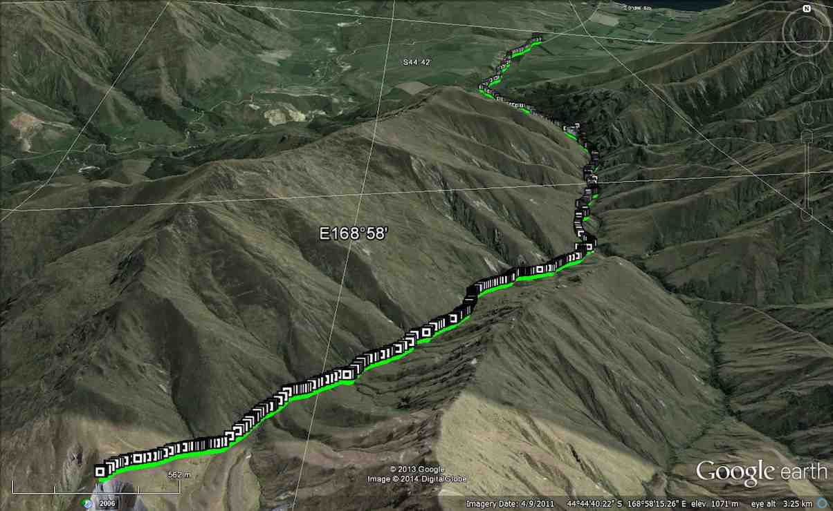
Motatapu Trip. We walked 21.7km; Moving time 7 hrs 19min; Ave 2.9km/hr; Climbed 1283mtrs asl; Total height climbed 1296mtrs.
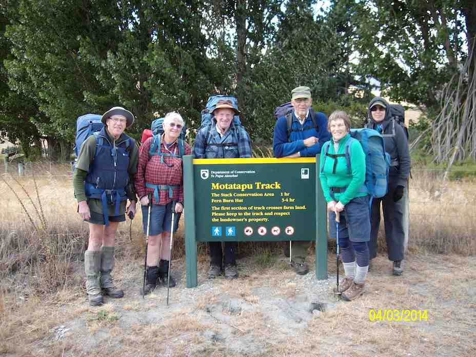
Away back about the middle of last year, while casting around for an adventure for the trampers, I came up with the idea of walking the Motatapu Track. After discussing this with a couple of others, it was decided to do the first 1/2 of the track only, as the logistics of getting cars to the other end was rather difficult. This track goes from the Glendu Bay end of Lake Wanaka, through to Macetown/Arrowtown via a walking track put in place by Soho Properties. It has 3 huts along it’s length which are very comfortable 12 bunk units.
We originally had 9 interested trampers, but this dwindled to 6 as time went on. We only had two informal meetings [one at the Waitati coffee shop, the other at Neil & Carole’s place] to sort out who was going to do what in the way of food, hut tickets, cars, etc.
4 of us left Mosgiel at 6am on the 4th March, to meet up with Neil & Carole in Wanaka, at Neil’s daughter’s place, where we quickly loaded up everybody’s packs with a share of the food supplies, had a cuppa, & then drove around to the start of the track …
Sign at the start. (Ken pic and caption)
… where 6 intrepid trampers set off on what we had been told many times was a rather hard slog.
It’s only 7 km to the first hut [Fern Burn], but when you are carrying 20+kg for the men & 15+kg for the women, & not used to it, it is quite a distance, & the track, apart from the first few kms, is narrow, & has some quite steep climbs, & drops along it’s length. One of the group [who shall remain nameless] pulled a muscle in a leg about 2 km from the hut, at a part of the most difficult/steepest section of the track & was unable to carry his pack, so Neil & I did a back & forward shuffle. We would carry our pack along the track a bit, then go back & pick up his, carry it forward some more, then go back for our own pack, & repeat the process, until we eventually got everybody, & everything to Fern Burn hut. As we sat around recovering, it was decided that the next day the injured party would stay at Fern Burn hut until the rest of us arrived back again. This meant that we could leave behind a small amount of our gear that we would not need for the next two days, so our packs would be marginally lighter.
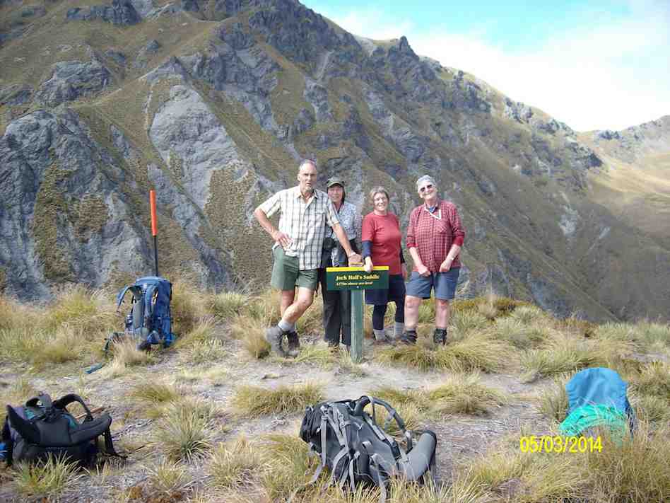
The next morning 5 set off on the 2nd leg to go to Highland Creek Hut, which is about 6 km away, but a much more arduous section of the track, & climbs to about 1280 mtrs ASL. After what seemed like hours, & many rest stops, we finally reached…
We made it!! The top of Jack Hall’s Saddle. (Ken pic and caption)
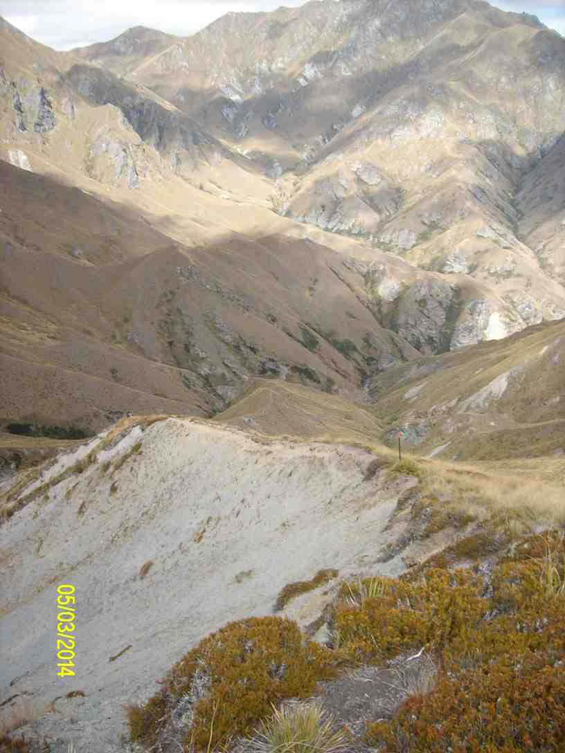
… the top of Jacks Pass [1280 mtrs] to a majestic view of the surrounding valleys & snow topped mountains, where we had a well deserved rest & lunch. On looking down the imposing other side, …
Looking down towards Highland Creek Hut (Ken pic and caption)
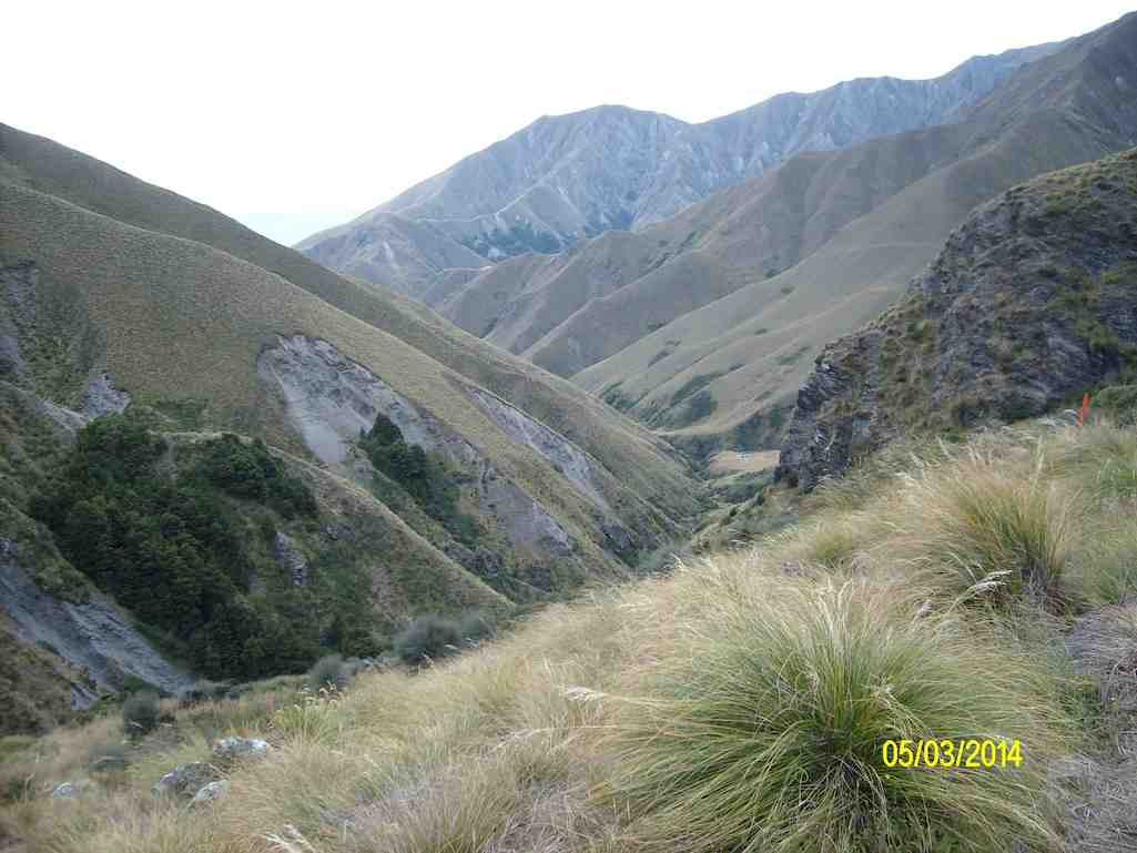
… [very narrow track along the top of a very steep, narrow ridge, with drops on either side] the ladies decided that they were not going any further, & that they would go back to Fern Burn hut. So it was left for me & Neil to decide what we would do. After discussing the prospect of having to climb back up the imposing track the next morning, we decided that, as we wouldn’t see much more than what we could from where we were, we would also go back to Fern Burn hut. I guess there was a sense of disappointment for us, that we wouldn’t fulfill our original idea of going to Highland Creek hut & back, but our tired bodies from yesterday’s efforts, told us that enough was enough. So we packed up after lunch, & headed back the way we had come. At least this time, it was mostly all downhill, …
Looking back to Fern Burn Hut (Ken pic and caption)
… & we made good time back to Fern Burn hut, where our injured member was reasonably surprised to see all of us coming back. We had only one incident on the way back, when another party member [who shall also remain nameless] had a leg collapse under them & toppled over the track edge. This was done without any damage to body or equipment, so all ended well.
After another good evening meal, a night’s sleep, & some breakfast, we packed up in preparation for the walk back to the cars. This time we shared out most of the contents of the injured person’s pack between the other members of the party, & sent the injured member off on his own to see how he would manage, the rest of us following about 1/4 – 1/2 an hour later. I finally caught up with him when he took a rest stop, about 2/3rds of the way out, so there was no real problem getting everybody back to the car park.
We had brilliant weather all the time, not too hot, & just about right for tramping. All agreed it had been a hard 3 days, but was enjoyable. A good bunch to go away with, & we had a good few laughs along the way. – Ken.
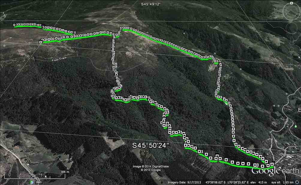
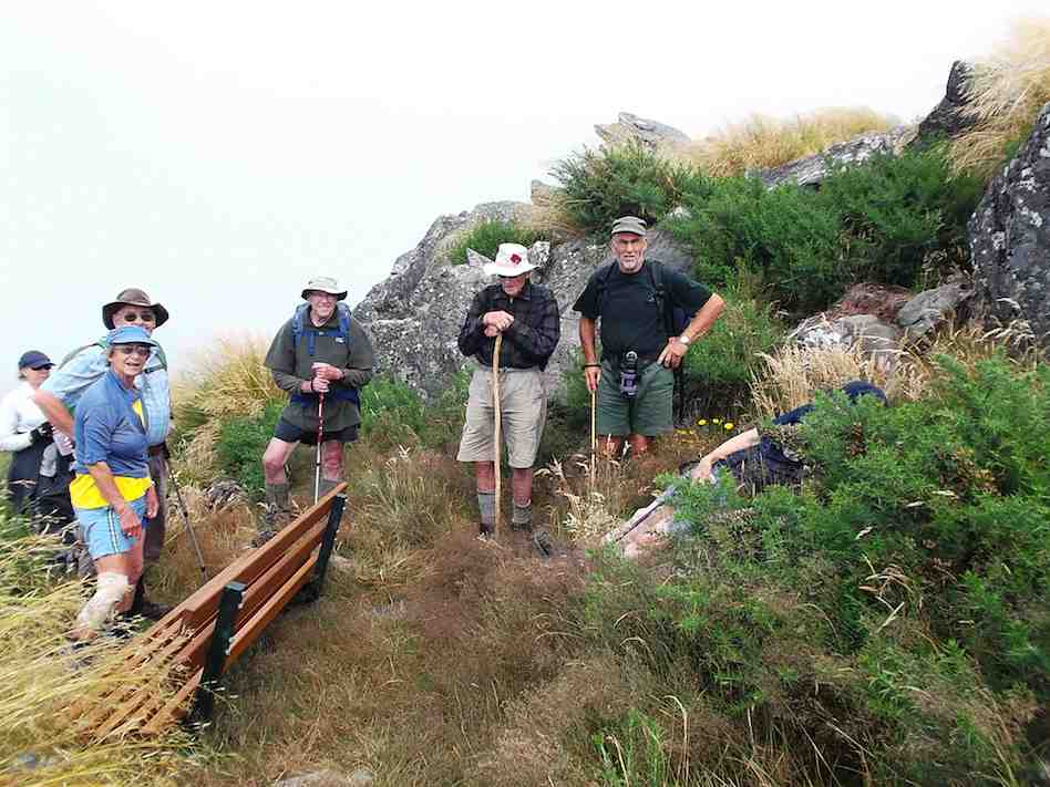
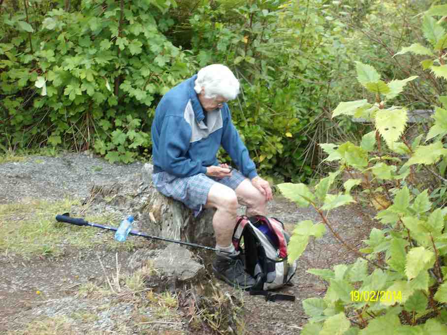
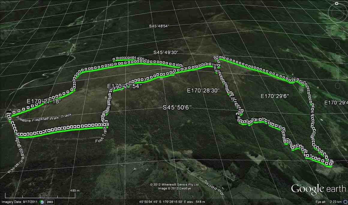
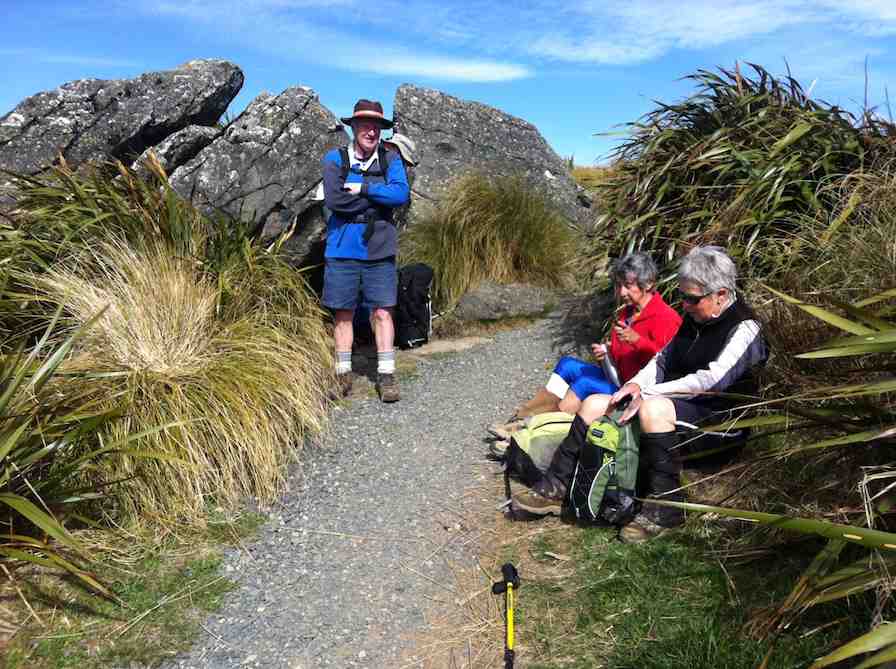
5. 19/2/2014. Trampers. Pineapple, Ben Rudd, Davies.
GPS of route., courtesy Ken. (Anti-clockwise from Booth Road) 9.2 km; 3 km/hr; 3 hr 6 min moving time; 2 hrs stopped!!; Climbed 589 mtrs.The group at the new seat. (Heb pic and caption)Afternoon tea break at the bottom of Davies track. (Ken pic and caption)Hazel in deep thought over her phone. (Ken pic and caption)
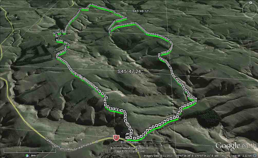
5. 30/10/2013. Trampers. Old Lee Stream Hotel and Valley.
GPS of route, courtesy Ken and Ian H. Distance 11.5 km; walking time 2 hr 52 mins; Ave 4 km/hr; Total ascent 376 mtrs.
A small group of keen trampers set off to Lee Stream Bridge on a fine day. The planned farm track turned out to be a formed, gravel road which we followed through lush, green paddocks across James Reid’s property. Half-an-hour of steady climbing led us to a morning tea stop by the patch of pines and then onwards and upwards to the top. The map route we were following stopped, but there was a timely meetup with the farmer-owner of the farm who showed us where to go to traverse the section not indicated on the map.
From the highest point on the farm (which was not very high) we looked across to Silver Peaks, Saddle Hill and over to Lea Stream School in the south-west. Due to snow, this school has the most non-school days in the country.
Further on, we looked down on the old Lee Stream Hotel nestled amongst the trees and from here we headed for our starting point reached by an easy downhill tramp across more paddocks and scattering ewes and lambs.
It was a very pleasant tramp of easy to moderate grade. – Neil.
4. 31/5/2000. Old Lee Stream Hotel and Valley. Lee Stream Ramble. Scorgies Farm. Leaders: Ria L, Catherine, Molly.
3. 27/7/1994. Old Lee Stream Hotel and Valley. Scorgies Farm. Medium. Leaders: Ted C, Jack R, Jack M, Bob H.
Great farmland round trip. Park cars up from Old Pub. Follow up the stream.
2. 15/5/1991. Old Lee Stream Hotel and Valley. A bit of history and nice rolling countryside. Easy. Leaders: Ted, Jack. Ivan, Shirley
1. 19/7/1989. Old Lee Stream Hotel. (Average). History pub. Follow up the stream. Leaders: Betty, Bob, Jean
4. 17/7/2013. Trampers. Rollinsons Rd, Rollinsons Track, Swampy Ridge track along to Hightop, & return.
4 trampers set out from the locked gate On Rollinsons Rd. which was a little icy in places & there was still some snow showing in parts as well. We were all amazed at the amount of destruction that the snow had caused, with 15cm Manuka splintered like matchwood, & everything sort of flattened.
We had morning tea in the shelter by the picnic area, & then climbed up to the elbow, where we went straight ahead on Rollinsons Track, which was running with water in parts, & covered with snow in other areas.
After reaching the Swampy Ridge track we set off towards Hightop, but soon found our way impeded by fallen Manuka. We negotiated this for a kilometer or two before arriving at a very large & difficult blockage, so as it was almost mid-day, we decided to have lunch, & then return to the cars. – Ken.
3. 31/3/2010. Trampers. Rollinsons, Swampy Ridge, Hightop. Leaders: Ria, Ian
The tramp differed from intentions. For one thing, the leaders had done no recce due to a failure to find a date suitable to both. For another, it had been four years since we had last tackled the track, and memories were a little hazy. Going in from the elbow of Rollinson Road, we were first surprised to find the Rollinson Track sign missing, replaced by one announcing “Tarns”. We wondered at this, but were pleased to find the track fairly well marked by fluorescent pink tape.
Early part of Rollinson Track
These led us helpfully deeper into the swamp. The dry summer had left the track beautifully only damp where there would normally have been mud.
Deeper into the swamp.
Second surprise. The helpful pink tapes had led us down to Swampy Lagoon. Obviously the “tarns”, or one of them. Were there others?
Swampy Lagoon
Oh dear. Where to from here? With reflective hindsight, we should have resisted the seductive tapes way further back and sought out the true Rollinsons, once upon a time indicated with Les Murcott’s green markers, some still there in places but now very faded. We should have paid them more attention. But we had been suckered by the pink. So what to do? We knew we were well off the track, and that anyway, up at the top was Swampy Ridge track. So we set off up a vertically vertical ridge, pulling ourselves up with tufts of tussock and grass, to eventually gain the track, after much heaving and huffing.
Looking back down steep ridge we had just climbed
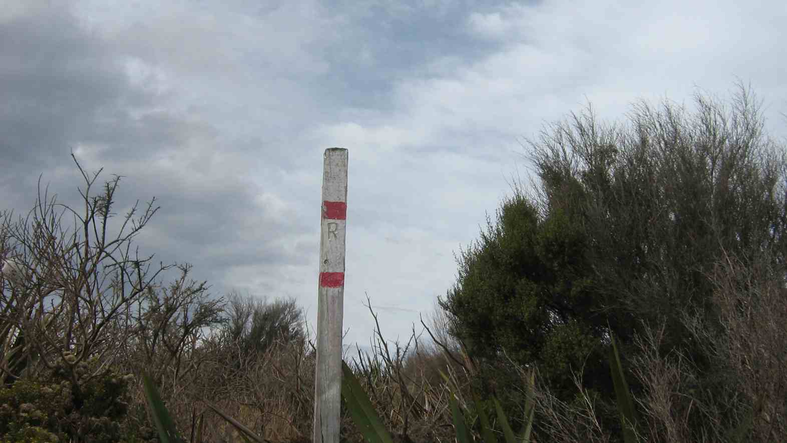
Later on, northwards to where the Ridge Track had considerably descended (!), we found the pole indicating where Rollinsons track DID emerge onto the ridge, by way of a MUCH easier climb.
“R” pole indicating Rollinsons track junction with Swampy Ridge.
Near the north end of Swampy Ridge Track,
North end of Swampy Ridge Track
we attempted a climb of Clump Peak on our right, as our way to Hightop on our left had appeared too scrubby.
Clump Peak viewed from the west
2. 5/10/1988. Swampy from Access Road gate. Average Climb. Great views around summit (bring binoculars. Return by Flagstaff weather permitting. Car shuttle if required. Leaders: Bob H, Ria L, Jean Y
But even here a thick belt of gorse blocked our way so we hunkered down for lunch interrupted by a VERY light shower which was magically terminated by dint of one or two of us donning parkas.
Back then, along Swampy Ridge and up to swampy summit topped by the Airways VHF receiver station. Descending the Rollinson accesss road to the elbow completed our extended circuit. Six of us had come out for the day. – Ian.
1. 5/10/1989. Swampy from Access/Rollinsons Road gate. Average climb. Great views around summit. Return by Flagstaff weather permitting. Car shuttle if required. Leaders: Bob, Ria, Mary.
9. 1/5/2013 Both. Steve Amies. Leaders: Ian and George.
This time we left from the schoolhouse, making it more of a road walk. We had morning tea on the lower Rollinson Rd and lunch in the track clearers’ picnic area, after inspecting the helicopter landing pad a little beyond.
As we returned down the road, we were surprised to see the helicopter, and shortly after the tank truck making their way towards where we had been. Apparently this was the day to carry out the weed spraying we had been notified about – and we were now making a timely exit. A tramp for 25 of us and of 10.5 km according to Peter’s pedometer and 25. – Ian.
8. 1/2/2012 Both. Steve Amies from Access Road. Leaders: Arthur and Barbara.
Sixteen of us left our cars at the locked gate on Rollinson access Rd and made our way up to the Track Clearers’ Picnic area. The leaders took us round many of the little nooks and crannies (they just seem to multiply of their own accord), stopping to inspect the labels fronting each bush planting. Of poignant note in front of one bush was a label printed with the name of Les Murcott, whose funeral a number of us had attended only a fortnight earlier.
We stopped off for our tea break.
Arthur led us down and across to Trig Q, and then on down Little Coal Creek until we got to the look-out. We careful negotiated some quite steep parts of the track and avoided any casualties. Then came the more arduous climb back up to the trig and across to the Steve Amies.
This latter track had a much more moderate decline (we stuck to only its upper reaches!), past another look-out, before making another turn around further down, to wander back up to the trig and on to the picnic area for lunch.
On the way across the wee saddle, we stopped to investigate the meaning of a sign indicating a sheltered area, whose side track opened out to a large open area in the bush, marked with a large white wooden equal-armed cross, laid flat on the grass. After some discussion, we decided the area was also to serve as a helicopter emergency landing spot. (There was even a ‘waiting room’ bench for passengers.)
Back up at the picnic area, our leaders discovered for us yet another alcove with ample tables and seats for a comfortable lunch.
A large ‘table’.A smaller one. (Admire Bruce’s head attire.)
Our leaders took us out to the road by a route different from the one we had entered by, and lo and behold, a salubrious shelter, doubtless erected by the track clearers for their comfort. Bravo.
Doug
Then we had only a stroll back down Rollinson Road to the cars. A leisurely 5.5 km walk, (as measured by two with their measuring devices.) Thank you, Barbara and Arthur for your careful leadership. – Ian.
7. 18/3/2009. Hikers. Steve Amies from Access Rd Hikers E+ Bev H, Joyce S
6. 25/7/2007. Hikers. Access Road, Steve Amies. Leaders: Bob H, Graham.
click to enlarge
Picnic Area nr Trig Q Fred, Marjorie, Joyce, Angela, Mollie, Wendy, Bev, Peter, Margaret, Elaine, Lesley
5. 19/5/2007 Trig Q from Silverstream via Steve Amies track. Steve Amies Track Circuit Leaders: Ria L, Hazel
4. 27/7/2005. Hikers. Steve Amies, Trig Q. Bob H, Les W, Mary M.
3. 2/2/2000. Trig Q from Silverstream via Steve Amies track. Steve Amies Track Circuit Leaders: Peter B, Lex
2. 23/10/1996. Trig Q. Average. Leaders: Margaret and Les, Doug J.
1. 7/6/1995Trig Q from Whare Flat School. Medium+. Shorter trip available. Leaders: Bob H, George, Jack R, Nancy
Bullring, Spiers Rd, Skyline, Swampy, McQuilkans, Whare Flat Rd. We travelled 10km; Moving ave. 3.5km/hr; Moving time 2h 50m; Total ascent 491mtrs.
Only 4 trampers went on this walk, which was very uneventful, until we couldn’t find the Jim Freeman track going back up to Ben Rudds shelter. We must’ve walked past it but didn’t see it. After looking around a bit we set off back up the road to return to the cars, vowing to do a recce from the top, to find where the Jim Freeman track meets up with McQuilkans track. – Ken.
Resting at Forestry 100 years memorial. Ian, Leonie, Abe, Ria, Glenice, Angela
Ria and Hazel took 7 of us from the Bullring up over Flagstaff, on and down the Pineapple track, then crossing over to the top of Ross Creek where we rested on seating by the Memorial celebrating the Dunedin City Forests 2006 Centennial which had suffered recent vandal damage and returning back up the Davies track,
Emerging from bush on Davies Track. Abe, Glenice, Ria
over onto Firebreak track with the majority returning to their cars but Ria taking Abe and Ian down to Big(or Bivvy) Rock.
Big Rock. Ria Abe
Hazel brought along a friend, Angela, a former neighbour of Ian’s back in the 70s! A delightful surprise for the two of them. – Ian
1. 31/7/1991. Booth Road from Pineapple Track and Bivvy Rock. Average. Leaders: Betty, Judith and Hugh, Peggy M, Frances.
Big Rock (Chimney)
It is possible to visit this rock by using a roughly marked route which has been cut from the Fire Break Track. The is also a possible route slightly further to the west. This massive rock outcrop has been used over many years as a place to bivouac and for rock climbing. There are good views over the valley.
– From Club’s Friend of Ben Rudd’s Certification – 1999.
A not very clear map of the tramp, I'm afraid, and reversed left to right. (Experimenting here with my Nike app and computer camera.) The route starts at the homestead at the top of the pic. A distance of 11 km return.
On a drizzly day, 8 hardy hopefuls elected to do the tramp, under the leadership of reluctant leader Lex, who, like most of the rest of the club would have preferred a warm dry stay at home, but eventually confessed he had enjoyed the day.
Nine of us met at Booth Road. We entered Davies Track via McGoun this time, exiting it on the left a short way up past the cairn. A light shower came on during the bush section, sounding quite pleasant as it struck the leaves overhead. Out in the tussock at the top, the weather was clear again. Ria and Hazel had discovered a new track had been made above the bush, this time striking to the left instead of the one to the left, the one that got several of us lost last time where overgrowth had rendered a crucial turn invisible.
We emerged on the Flagstaff walkway above a rock outcrop and headed down to the top of the Pineapple. Here Gay, a visitor, left us and we continued along Swampy Ridge to the top of the Nicols/Moonlight track. A little way in and we found the track has been ruined by mountain bike wheels cutting a narrow deep groove down the track middle, making keeping our footing on the restricted track-sides difficult and dangerous. Further down, we kept to the Moonlight side of Nicols Creek and traced, where we could, the original track, bisected however by the zigzags of the mountain bike route. Rain now really set in and we sheltered in nearby bush for lunch. We then continued down the old track, through the macrocarpas, the stone outcrop and yet further carefully down to emerge at the creek crossing below the waterfall – to Ian’s delight but Ria’s chagrin who had hoped to emerge onto the Leith Valley road on the north side instead of now forced across to the other side. So it was down and out and up Islay St back to the cars. All felt it had been another good day out. Too dull and showery for photo opportunities however. – Ian.
2. 14/11/2007. Trampers. Woodhaugh, Ross Creek, Davies, Pineapple, Ross Creek return. Moderate. Leaders: Ria, Hazel.
Stream crossing. Doug, George, Peter, Wendy
The route Ria and Hazel took ten of us on provided plenty of variety both in scenery and weather. We approached Davies track by way of Ross Creek Reservoir from Woodhaugh. After Ross Creek it was through cleared forest before climbing through secondary growth …
… on the foothill slopes of Flagstaff before entering beautiful native forest and and hour later emerging on Flagstaff’s tussock and flax with overcast views of the harbour and Dunedin both north and south. We had encountered occasional showers to this point and now out on the tussock it was turning really cold. We were still not prepared upon reaching the upper Pineapple-Flagstaff track …
Made it onto Pineapple. Ria, Sabina, Glenice, George, Keith
… to be pelted by a fierce but fortunately brief hail storm. We quickly made our way down to the junction with the Swampy Ridge track where now the hail had now been …
Snow. Doug, George, Sabina, Keith, Glenice
… replaced with snow. So it was down, down the Pineapple to the sheltered edge of the bush where we lunched in the now fitful sunshine. Then the bush, Booth Road, back through Ross Creek tracks and down past the reservoir until the last scenic bush gave way to Woodhaugh St and back to the cars. An interesting day. – Ian
In Leith Valley, where Otago’s first industry – sawmilling – is reputed to have started about the 1860s, is the start of the old Pineapple Track.
Originally, it was named Ross Track, after Archibald Hilson Ross, who owned most of the land in the vicinity. In the early 1920s, Mr Oscar Balk, first president of the Otago Tramping Club, led parties of trampers up this route. At the top of a rather steep section, the parties would stop to rest and often refresh themselves with a tin of pineapple. This tin was sometimes left hanging on a tree or fence, and the track came to be called the Pineapple Track.
The line of the Pineapple Walkway has deviated from the original track in places to provide more scenic variation.
The original vegetation of the area has been modified as a result of early milling, burning and stock grazing, but remnants of the milled species (podocarps) still remain. Rimu, miro, totara and matai are found in isolated pockets, mainly in damp gullies. Even so, the overall distribution of plant species retains some semblance of natural order with the larger forest trees growing at lower altitudes. Podocarp broad-leaved forest type occurs with shrub species which grade out into Dracophyllum shrub land and ultimately tussock grassland communities on the summit area.
Some common plants: fuchsia, pepper tree, lemonwood, broadleaf, totara, five’finger, wineberry, lancewood, Muehlenbeckia, Dracophyllum, Coprosma, Hebe, and wild spaniard tussock.
There are many varieties of birds in the bush areas where there is an ample food supply to sustain many nectar-, berry-, and insect-eating native birds.
Some of these are: New Zealand pigeon, bellbird, fantail, tomtit, brown creeper, tui, silvereye, rifleman and pipit.
1. 17/10/2001. Trampers. Nicols Creek – Swampy Saddle – Warburton Track. Leaders: Lex, Mary L, Irene.