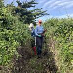
 06/05/2026. Track Clearing – Boulder Beach Leader: Pam Cocks
Trio of Pam, Gwenda and Yan…
Mid-week recreational and social walking group based in Mosgiel NZ

06/05/2026. Track Clearing – Boulder Beach Leader: Pam Cocks
Trio of Pam, Gwenda and Yan…
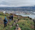
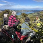
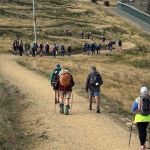
 29/04/2026. Signal Hill from Ravenbourne. Grade 4. Trampers. Leaders: Sandy Webb & Gail Williams.
23 trampers met at Rimu St and began the trek uphill via the Signal Hill and Telecom tracks.
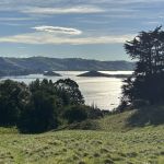 29/04/2026. Macandrew Bay, Company Bay, Camp Road, Pukehiki, Greenacres Track. Grade 3.5. Hikers. Leaders: Jenni Wright & Jill Dodd.
The weather gods were on our side as we left Mosgiel and arrived for our destination, Macandrew Bay car park, where we met our Dunedin and Brighton contingent
Continue reading “Macandrew Bay, Company Bay, Camp Road, Pukehiki, Greenacres Track”
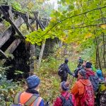 22/04/2026. Craiglowan Falls. Grade 4. Trampers. Leaders: Katrina McKenzie and Julie McKenzie.
After much pondering and phone calls to the club kaumatua we decided to go ahead with the walk despite more rain since the recce. Continue reading “Craiglowan Falls”
 22/04/2026. Bayfield Park/Around Eastern side of Harbour. Grade 2. Hikers. Leaders: Jenny Finnerty, Jay Devlin, Jan Butcher and Pam Clough.
Leaving Memorial Park it was not looking good weather-wise but it soon cleared on arriving at Bayfield Park although hats & gloves were needed. Continue reading “Bayfield Park – Around Eastern side of harbour”
 15/04/2026. Cedar Farm to Mount Cutten. Grade 3.5. Hikers. Leaders: Wendy Langley and Jill Thomas.
On a bright sunny morning with no wind 12 of us set off up to the Cedar Farm reservoir.
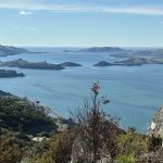
 15/04/2026. Kaik-Otakou. Grade 3. Trampers. Leaders: Sylvia Watts and Carolyn Pridham.
On a super lovely day we headed down the Otago Peninsula to Otakou all stopping near the bus stop.
 08/04/2026. Taieri View Farm Tramp. Grade 3. Trampers. Leaders: Jill Reid and Sue Johnstone.
After parking on Taioma Rd, our group of 20 trampers set out on an overcast morning which offered good district views.
 08/04/2026. Purakaunui Curcuit. Grade 2. Hikers. Leaders: Katrina Mc Kenzie and Cathy Ferguson.
On a pleasant morning 15 hikers meet up with 6 others at Port Chalmers turn off and drove to Purakaunui Domain, where we had our morning tea stop.
PRESIDENT’S REPORT APRIL 2026
The phenomenon that time goes quicker (or seems to) as we age is an interesting one – scientifically explained by the “proportionality theory” and “Janet’s Law”. Anyway it seems like only yesterday that the new year 2026 had just begun and already we’re a quarter of the way through it! In this report I’ll hopefully inform of what’s ahead in 2026, with some reporting and reflections on the year to date. Continue reading “President Update – April 2026”
 01/04/2026. Coastal Connection/ Orokanui Lagoon Walk. Grade 3. Combined. Leaders: Pam Cocks; Tail-end Charlies: Val Cayford, Julie McKenzie, Adrienne Ensor
On a beautiful brisk Autumn morning 36 intrepid trampers and hikers assembled at Black Bridge on Doctors Point Road.
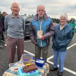 01/04/2026. Life member, Lester is turning 95
Before we left Memorial Park on Wednesday ,we had an early acknowledgment of our oldest life member of the club ,Lester Harvey’s imminent 95th birthday. Continue reading “Lester is 95”
 25/03/2026. Post Office Creek from Mahinerangi Dam end. Grade 3. Hikers. Leaders: Peter Dodds and Barbara Shackell.
It was a lovely day for our 18 intrepid hikers on the Mahinerangi Track. Continue reading “Post Office Creek from Mahinerangi Dam end”
 25/03/2026. Whare Flat-Racemans-North Coal Creek-Steve Amies-Return. Grade 4. Trampers. Leaders: Robyn and Martin Hickley.
Nineteen trampers left the Whare Flat carpark under low cloud and mild temperatures. Continue reading “Whare Flat – Racemans – North Coal Creek – Steve Amies Return”
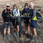 09/03/2026 to 13/03/2026. Bannockburn Camp – 45th Parallel. Combined. Leaders: Anne and Rod Ward.
Continue reading “Bannockburn Camp 2026 (Day 5) – 45th Parrallel”