
 21/01/2026. Owaka / Catlins Environ. Grade 2.5. Hikers. Leaders: Bill Cubitt and Peter Beal.
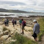
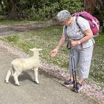
The weather (albeit a little windy) and tides turned up trumps for the 29 hikers who gathered on the Pounawea waterfront at 10.00am on Wednesday morning. Continue reading “Owaka / Catlins Environ”
Category: Year round
Hoopers Inlet – Rutherfords – Stewarts – Lime Kilns – Nyhon track
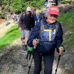
 14/01/2026. Hoopers Inlet, Rutherfords – Stewarts, Lime Kilns, Nyhon Track. Grade 3. Trampers. Leaders: Spen Walker, Jane Bruce, Sandy Webb
The Mosgiel contingent had an 8.30 am start and arrived at Shore St before 9 am, ably coordinated by Neil Hodgkin.
Continue reading “Hoopers Inlet – Rutherfords – Stewarts – Lime Kilns – Nyhon track”
Millenium Track from Taieri Mouth to Lookout
 03/12/2025. Millenium Track from Taieri Mouth to Lookout. Grade 3. Trampers. Leaders: Sandy Webb and Alison Evans.
The weather gods were not on our side, so the planned Silver Peaks tramp was reluctantly shelved for another day. Continue reading “Millenium Track from Taieri Mouth to Lookout”
Big Easy Track
 26/11/2025. Bid Easy Track. Grade 2.5. Hikers. Leaders: Barbara Shackell and Avis Williamson
Twenty-six hikers met up at Signal Hill Reserve behind Logan Park High School.
Highcliff, Paradise and Buskin Tracks
 26/11/2025. Highcliff, Paradise and Buskin Tracks. Grade 4. Trampers. Leaders: Clare Banks and Carol Thurlow
23 trampers left the entrance to the Highcliff Track carpark at 9.35am, knowing very hot and blustery conditions were forecasted for the day. Continue reading “Highcliff, Paradise and Buskin Tracks”
Out and About in Caversham and Kew
 19/11/2025. Out & About in Caversham and Kew. Hikers. Grade 2 $5 14km. Leaders: Jenny Finnerty, Jay Devlin, Jan Butcher, Pam Clough.
25 hikers set out on a very pleasant morning for our walkabout.
Three Peaks, Escarpment, Cloud Forest Loop
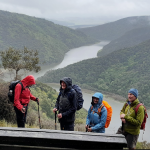
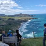
 12/11/2025. Three Peaks, Escarpment, Cloud Forest Loop. Grade 3.5. Trampers. Leaders: Sarah McCormack and Karen McInnis.
22 trampers set off from Sullivans dam in blustery conditions but it was sunny and not cold.
Continue reading “Three Peaks, Escarpment, Cloud Forest Loop”
Second Beach to Ocean Grove
 12/11/2025. Second Beach to Ocean Grove. Grade 3. Hikers. Leaders: Sandra Lawn and Bruce Spittle.
It was predicted to be windy for our hike and boy oh boy was it windy.
Working Bee – Future Forest – Broad Bay
 05/11/2025. Future Forest – Broad bay. Grade 2.5. Combined. Leaders: Jenny Flack, Linda Partridge, Gwenda Farquharson, Pam Cocks.
After a bit of overnight rain in Broad Bay the weather was fine for our working bee at the Future Forest, third attempt lucky for us this time. Continue reading “Working Bee – Future Forest – Broad Bay”
Karetai Track to Boulder Beach
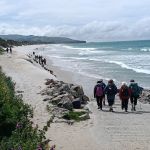
 29/10/2025. Smaills Beach (Karetai Track) to Boulder Beach Outlook. Grade 3. Hikers. Leaders: Jenni & Bruce Wright.
Was it cabin fever that brought 39 adventurers out after a rough bout of weather the previous few days?
Orokonui Lagoon/Waitati
 22/10/2025. Orokonui Lagoon/Waitati Grade 2. Hikers. Leaders: Phil and Raewyn Keene.
On doing the recce we discovered that the Opeke Track, normally part of this hike, is now closed to the public……
Outram Glen and Beyond
 22/10/2025. Outram Glen and Beyond. Grade 2. Trampers. Leaders: Jill Reid and Heather Kirk.
We had 20 happy trampers arrive at Outram for our walk on Wednesday.
Goodwood Road, Bobby’s Head, Puketapu
Bobby’s Head, near Palmerston. Also Puketapu.
69 km from car-park
 7. 19/6/2024 Bobby’s Head expand. Grade 2.5 Leaders Barbara Shackell and Dave Mellish
The weather report was not that exciting for the planned trip to the Bobbys Head area east of Palmerston.
Ross Creek and Environs
No. 94 on old hardcopy list of 113 club tramps. “Ross Creek – McGlashan College Year Round” 17 km from car park.
Ross Creek, Lower Leith Valley, Wakari Rd Bike Park, McGouns, Pineapple and Davies Tracks – Information and Trips Library
34. 15/05/2024 Ross Creek/ McGouns Track Grade: 2.5 Leaders: Pam and Jay
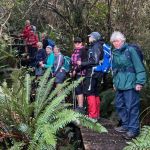
 On a fabulous autumn Day 25 keen walkers parked in Booth Road which is at the bottom of the Pineapple Track.
Macandrew Bay, Greenacre Street
No. 6 on old hardcopy list of 113 club tramps. “Macandrew Bay. (Greenacres St). J Allen. Year Round.”
No. 74 on old hardcopy list of 113 club tramps. “Peninsula Traverse. Year Round”
Distance from car-park: 24 km.
12. 08/05/2024 Hikers. Macandrew Bay, Greenacres. Grade 2
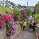
 23 hikers set out from MacAndrew Bay heading to Company Bay stopping at the Yellow Eyed Penguin plant nursery. Continue reading “Macandrew Bay, Greenacre Street”