Scope:
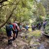
This page of club tramps and hikes on the Otago Peninsula groups together trips to Boulder Beach from Macandrew Bay (Greenacres St), Braidwood Road. These trips will often include the Paradise, Buskins, Highcliff Tracks.
Background Information:
Road distances from Mosgiel carpark.
TRTC Grading Information – trips incorporating these tracks are generally given a TRTC grading of about 3. This is indicative only, as trips can be allocated a higher or lesser grading depending on the route taken. For more detailed analysis refer to Grading Information.
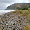
Access to Boulder Beach is closed to the public for penguins breeding (November – February). Other tracks remain open year round.
How To Get There:
(1) From Macandrew Bay proceed up Greenacres St / Track which exits onto Highcliff Road. Turn right onto Highcliff Road and proceed to the start of Paradise Track. This track will take you to Boulder Beach.
(2) Proceed along Highcliff Road and turn left (past Pukehiki) onto Seal Point Road. Follow this road and turn right onto Braidwood Road. At the end of this road is Highcliff Track. Follow this track through the dunes to the junction with Paradise Track then right to Boulder Beach.
Links to tramps and hikes in this area:
10/06/2026. Boulder Beach. Grade 3. Trampers. . Leaders: Pam Cocks and Gail Williams.
Boulder Beach (2024 – 1991) 18 trips – 6 with reports and photos, 2 with photos only, 11 with no reports or photos.

 . Trampers. Macandrew Bay to Boulder Beach and return. Leaders Pam and Gwenda
 Sometimes my grandmother would say something to me, and I’d ask,
 18. 24/04/2024. Hikers. Graham’s Bush/Organ Pipes. Grade 3. 27 km. Leaders: Maria MacNee/Theresa White
 9. 17 /4/2024. Trampers Rosella Ridge. Grade 5.5 Leaders: Ross and Neil
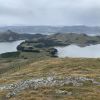 12. 10/4/2024 Mt Charles Grade 4 Leaders: Graham and Carol Thurlow
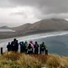 25. 27/03/2024. Hikers. Sandymount Grade 2.5 Leaders: Jenni and Bruce Wright
 I’ve always regarded myself as, and indeed endeavoured to be, an optimist. But on Tuesday night, I had serious doubts that Wednesday’s tramp would proceed. That night seemed to leave little room for optimism. A Wednesday morning early dog walk gave a glimmer of hope, that the weather, although unpredictable, might be improving. Seventeen ‘optimistic’ trampers took part on the Split Rock tramp.
 17. 13/03/2024. Trampers. Carey’s Creek, Rongomai, Honeycomb Tracks. Grade 3.5. $11. 39km. Leaders: Pam Cocks, Graeme Souter.
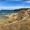 15. 06/03/2024. Combined. Waikouaiti
 13 trampers had a “Rock Day” beginning with rock music at Peter Johnson Park where athletic sports were about to start.
 18. 14/2/2024. Trampers. Maungatua Option. Leaders Lyn Keene, Anne Ward and Di Bezett
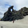 Hikers: Leaders Heather and Val Cayford
 11 trampers left PJ Park at 8.45 and meet up with 5 Dunedin trampers on Borlases’s Road, Port Chalmers. We continued onto Blueskin road in misty weather which got thicker as we drove up to park 1km north from Cedar Farm Forest carpark (CFF) A car was left at CFF carpark to ferry drivers back to their cars at the end of tramp.