Click on Map to Enlarge
Taieri Recreational Tramping Club
Mid-week recreational and social walking group based in Mosgiel NZ

Click on Map to Enlarge
Click on Map to Enlarge
Click on Map to Enlarge
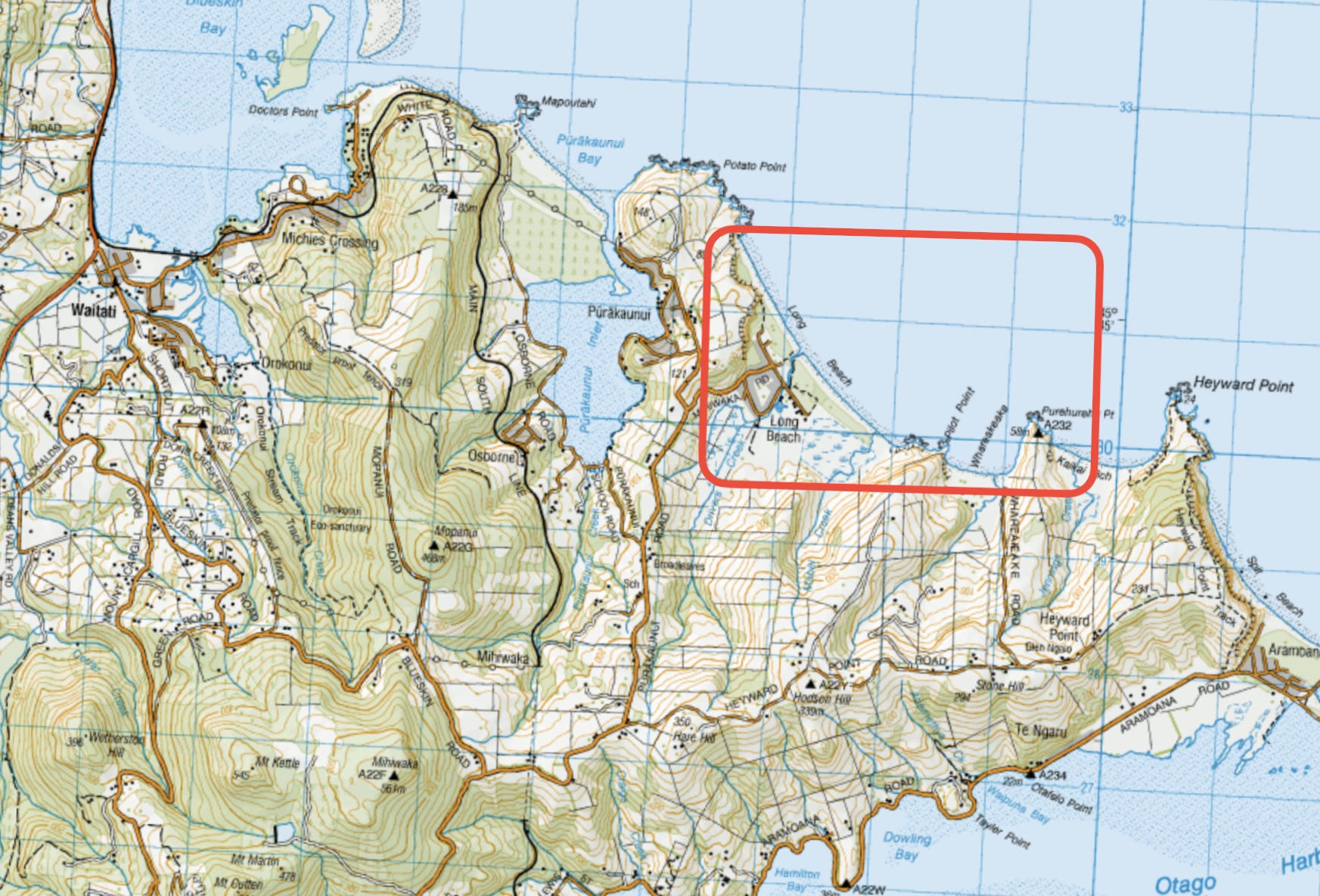
This page of club tramps and hikes in the West Harbour area groups together trips to Long Beach. (map)
Road distances from Mosgiel carpark.
Long Beach. 2019 – 2004 (5 trips, 3 with reports and photos, 2 with no report or photos)
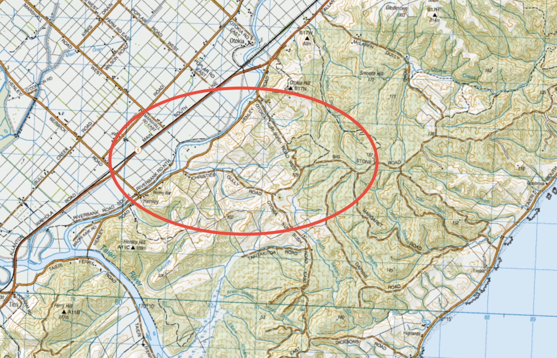
This page of club tramps and hikes in the South Coast via SH1 area groups together trips incorporating Henley Road, Big Stone Road, Otokia Road and Christies Gully. (map)
Road distances from Mosgiel carpark.
TRTC Grading Information – trips incorporating these tracks are generally given a TRTC grading of about 3. This is indicative only, as trips can be allocated a higher or lesser grading depending on the route taken. For more detailed analysis refer to Grading Information.
28/05/2025. Henley Loop. Grade 2.5. Hikers. Leaders: Rhonda Wilson and Jill Dodd.
Christie Gully, Big Stone Road, Otokia, McLaren Gully Rds. 2014 – 1991. (17 trips, 1 with report and photos, 2 with photos only, 14 with no reports or photos)
Palmers Creek Otokia Cemetery Henley. 2002 – 1994. (3 trips, no reports or photos)
This page of club tramps and hikes covers trips on the North Coast north of Dunedin City, Waitati involving club trips to Dunback incorporating the Shag / Waihemo River
Road distances from Mosgiel carpark.
TRTC Grading Information – trips to the Dunback township are generally given a TRTC grading of 2. This is indicative only, as depending on the route taken, allocation of gradings can differ from this. For more detailed analysis refer to Grading Information.
30/04/2025. Dunback Shag/Waihemo River Walk. Grade 2. Hikers. Leaders: Neville Griffiths, Dave Roberts. (see notes relating to the history of area linked this post)
Click on map to enlarge
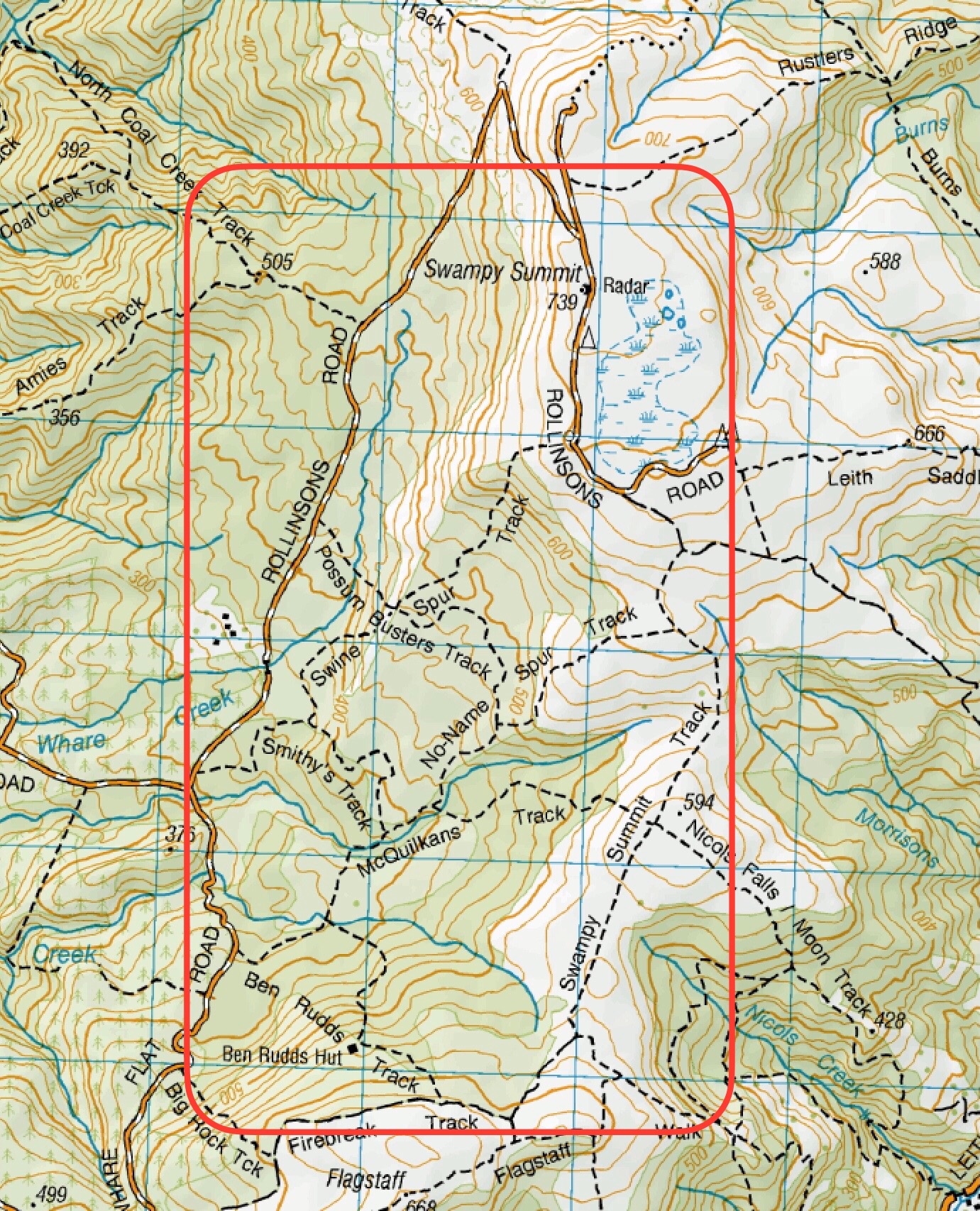
This page of club tramps and hikes in the area of Whare Flat and groups together trips to tracks east of Rollinsons Road and includes the following tracks: Ben Rudd, McQuilkans, Possum Busters, Smithys, Swampy Summit Swinespur, (map)
Road distances from Mosgiel carpark.
Swampy ridge track background information.
Ben Rudd Property and the Otago Tramping Club Inc
Rollinsons Rd Locked gate, Swinespur, Swampy Ridge, McQuilkans, Smithies. 2024 – 2009 (5 trips, all with reports and photos)
Rollinsons, Swampy, Swine Spur. 2019 – 1989 (8 trips, 4 with reports and photos, 4 with no reports or photos)
Swampy from Access/Rollinsons Road. 2013 – 1989 (4 trips, 1 with report and photos, 3 with no reports or photos)
Possum Busters and nearby tracks tramps. 2021 – 2000 (10 relevant trips, 9 with report and photos, 1 with no report or photos)
Moon, McQuilkan, Possum Hunters, Jim Freeman, Pineapple, Nicols 26/11/2008 (1 trip with report and photos)
This page of club tramps and hikes in the Fairfield, Green Island and Mosgiel surrounds area and groups together trips incorporating Lower Silverstream and Invermay.
Road distances from Mosgiel carpark.
Former Foot-bridge over Silverstream. Also Swing-bridge
Lower Silverstream tramps. 2023 – 1996 (23 trips, 8 with report and photos, 5 with reports only, 8 with no reports, 2 with photos only)
Invermay/Silverstream 29/6/2022 (1 trip with report and photos)
This page of club tramps and hikes in the Silver Peaks area groups together trips to the South Branch of the Waikouati River
Road distances from Mosgiel carpark.
TRTC Grading Information – trips to the South Waikouaiti River track are generally given a TRTC grading of 4. This is indicative only, as depending on the route taken, allocation of gradings can differ from this. For more detailed analysis refer to Grading Information.
Mountain Road / South Waikouaiti River. 2024 – 2021 (2 trips, both with reports and photos)
This page of club tramps and hikes in the Silver Peaks area groups together trips to Jubilee Hut (incorporates Christmas Creek, Silverpeaks Station, Lamb Hill, Mt John). (map)
Road distances from Mosgiel carpark.
TRTC Grading Information – trips to Jubilee Hut are generally given a TRTC grading of 5. This is indicative only, as depending on the route taken, allocation of gradings can differ from this. For more detailed analysis refer to Grading Information.
Access Permissions are required as this trip ventures over a working farm – refer guidelines
Jubilee Hut is located in the Silverpeaks areas and can be accessed by numerous tracks. TRTC preferred access is via Hindon via Silverpeaks Station and Christmas Creek.
Taking George King Memorial Drive (turn right after crossing the bridge over the Taieri River just out of Outram) and follow the road past Lee Stream. Turn right onto Hindon Road which descends to the Hindon Railway Station. Cross the Taieri River (via rail/road bridge) and take to Silverpaeaks Station and parking.
Silverpeaks Station to Jubilee, Orange & Mount John Huts. 2020 – 1999 (7 trips, 5 with reports and photos, 1 with photos only, 1 with no report or photos)
This page of club tramps and hikes covers trips on the North Coast north of Dunedin City, Waitati involving club trips to Lawsons Farm. (map)
Road distances from Mosgiel carpark.
Access Permissions are required as this trip ventures over a working farm – refer guidelines
Lawsons Farm. From Homestead. Clockwise or Figure of Eight. 1991 – 2023. 18 trips (9 with reports and photos, 4 with no reports or photos, 4 with photos only, 1 with report only)
Orbells Crossing, Northern Lawsons Farm. 1991 – 2018. 9 trips (4 with reports and photos, 5 with no reports or photos)
This page of club tramps and hikes to the West Harbour area groups together trips incorporating the Otago Harbour cycle/ walk way via Ravensbourne, Mia, Burkes, St Leonards to Port Chalmers.
Road distances from Mosgiel carpark.
West Harbour Recreation Trail. 2009 – 2022 (8 trips, 6 with reports and photos, 1 with no report, 1 with report and no photos)
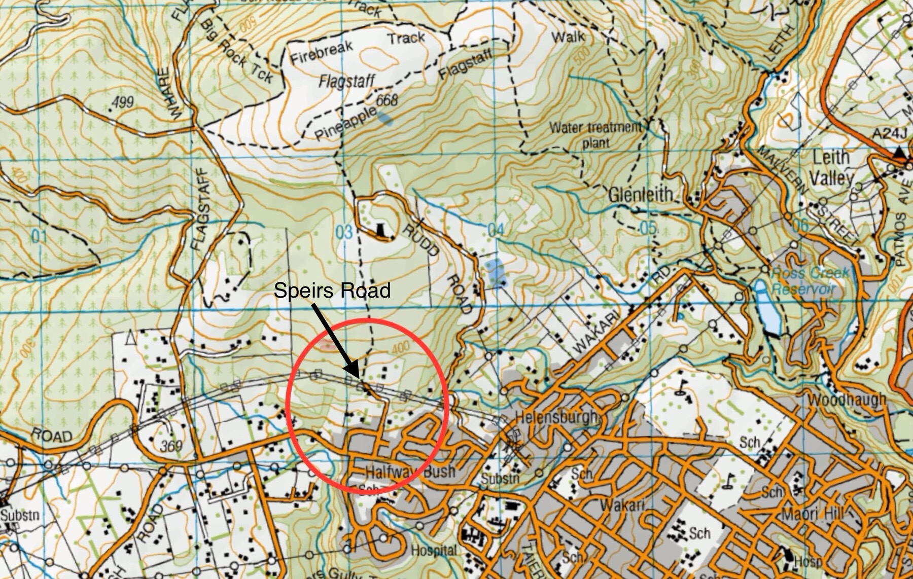
This page of club tramps and hikes in the Dunedin Central City area groups together trips from to the Westside of Flagstaff, incorporating Speirs Road, Pineapple Track, Davies Track and McGouns Track. (map)
Road distances from Mosgiel carpark.
TRTC Grading Information – trips to the West of Flagstaff from Spiers Road, incorporating tracks on Flagstaff are generally given a TRTC grading of between 4 to 5. This is indicative only, as depending on the route taken, track conditions etc. allocation of gradings can differ from this. For more detailed analysis refer to Grading Information.
23/04/2025. West of Flagstaff via Spiers Track. Grade 4.5. Trampers. Leaders: Pam Cocks & Karen McInnes.
Possum Busters and nearby tracks tramps – includes 2 trips to the West of Flagstaff. 12/7/2023 and 24/8/2022 (report and photos included for both)
Spiers Road, Davies, McGouns Creek Extension. 2009 – 2018 (4 trips, reports and photos attached)
This page groups together those special social occasions (not including midwinter, Christmas dinners etc) hosted by the club.
28/03/2025. Catch up and chin wag. Combined. Arranged by Jenni Wright