Click on Map to Enlarge
Taieri Recreational Tramping Club
Mid-week recreational and social walking group based in Mosgiel NZ

Click on Map to Enlarge
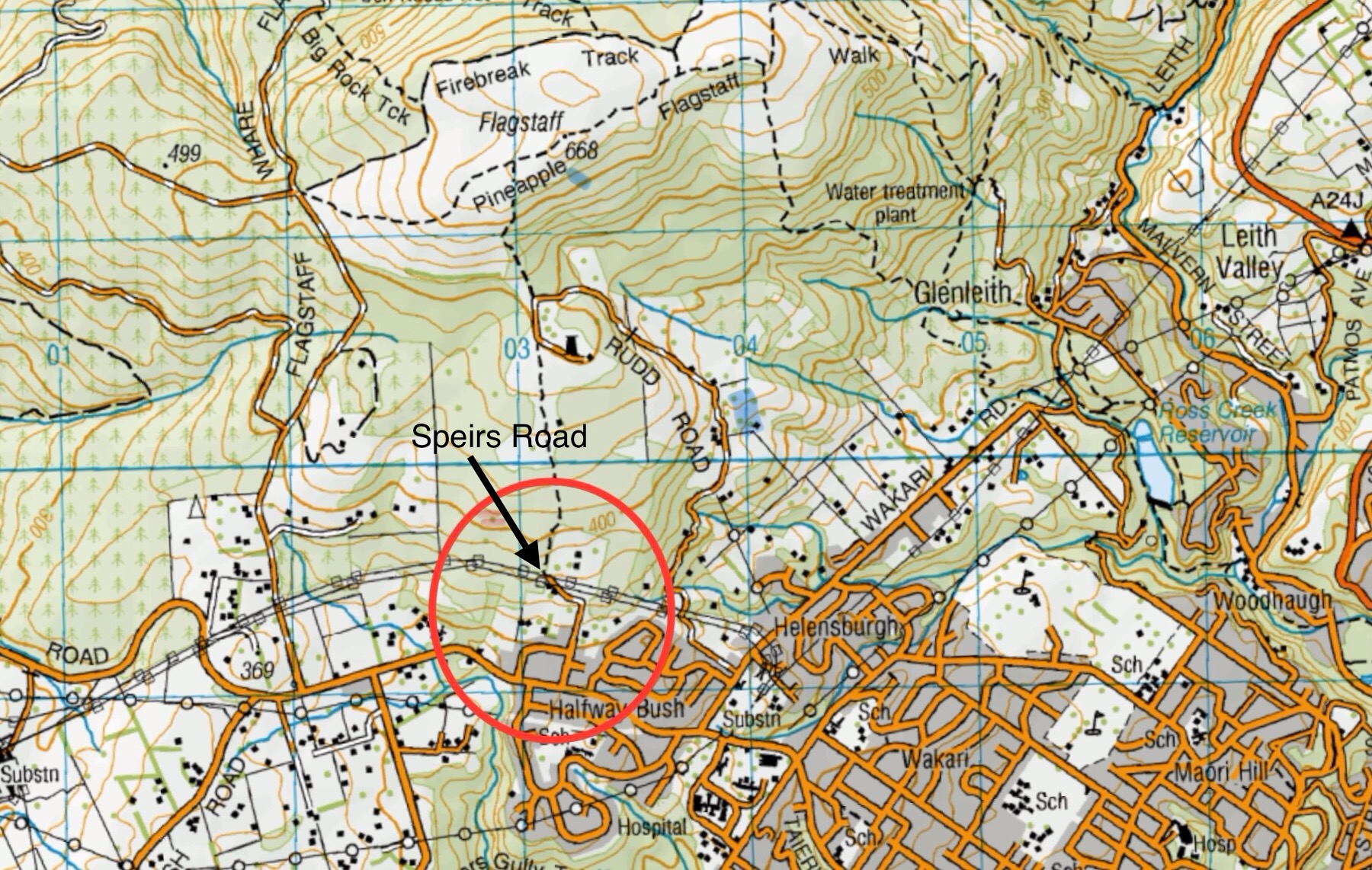
This page of club tramps and hikes in the Dunedin Central City area groups together trips from to the Westside of Flagstaff, incorporating Speirs Road, Pineapple Track, Davies Track and McGouns Track. (map)
Road distances from Mosgiel carpark.
TRTC Grading Information – trips to the West of Flagstaff from Spiers Road, incorporating tracks on Flagstaff are generally given a TRTC grading of between 4 to 5. This is indicative only, as depending on the route taken, track conditions etc. allocation of gradings can differ from this. For more detailed analysis refer to Grading Information.
23/04/2025. West of Flagstaff via Spiers Track. Grade 4.5. Trampers. Leaders: Pam Cocks & Karen McInnes.
Possum Busters and nearby tracks tramps – includes 2 trips to the West of Flagstaff. 12/7/2023 and 24/8/2022 (report and photos included for both)
Spiers Road, Davies, McGouns Creek Extension. 2009 – 2018 (4 trips, reports and photos attached)
This page of club tramps and hikes in the Dunedin Central City area groups together trips from the Dunedin Botanic Garden to Pine Hill and return.
Road distances from Mosgiel carpark.
26/02/2025. Gardens, Pine Hill Return. Grade 2. Hikers. Leaders: Jenny Finnerty, Kay Seddon.
Gardens – Pinehill Return 2006 – 2023 – 4 trips (3 with reports and photos, 1 with no report or photos)
Click on map to enlarge
Click on map to enlarge
Click on Map to Enlarge
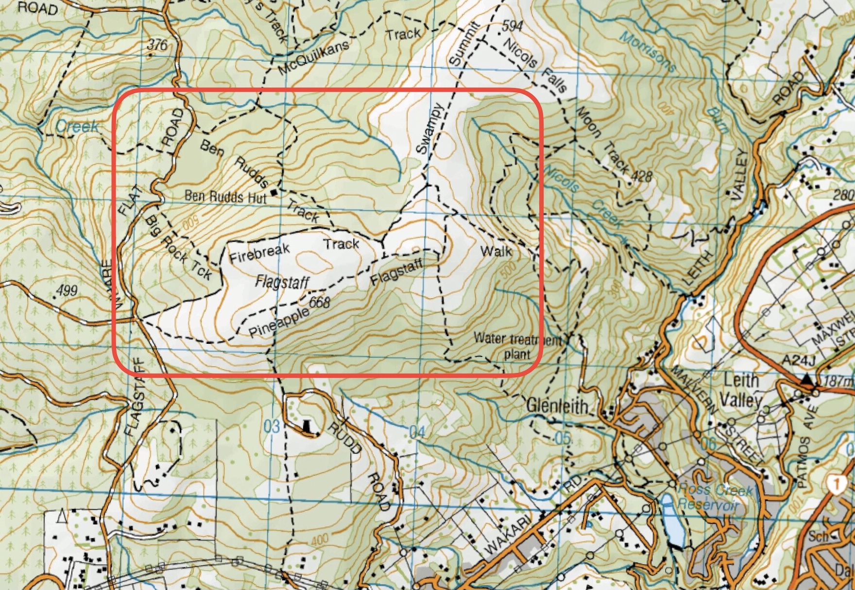
This page of club tramps and hikes in the Dunedin Central City area groups together trips from the Bull Ring (Flagstaff / Whare Flat Road) and incorporates the Flagstaff Walkway, Pineapple Track and Ben Rudd shelter. (map)
Road distances from Mosgiel carpark.
Location: 13.3 km from car-park.
Dunedin’s Hills’ History for background information.
Pineapple Track for background information.
Pineapple and Flagstaff walk for background information.
Flagstaff Name for its origin.
Ben Rudd Article for background information.
23/10/2024. Flagstaff, Bull Ring. Hikers. Leaders: Theresa White, Julie MacKenzie.
Bull Ring, Flagstaff Walkway/ Pineapple Track. 2018 – 2008 (8 trips, 3 with reports and photos, 2 with photos only, 3 with no reports or photos)
Bull Ring, Ben Rudd. 2024 – 1995 (13 trips, 3 with reports and photos, 10 with no reports)
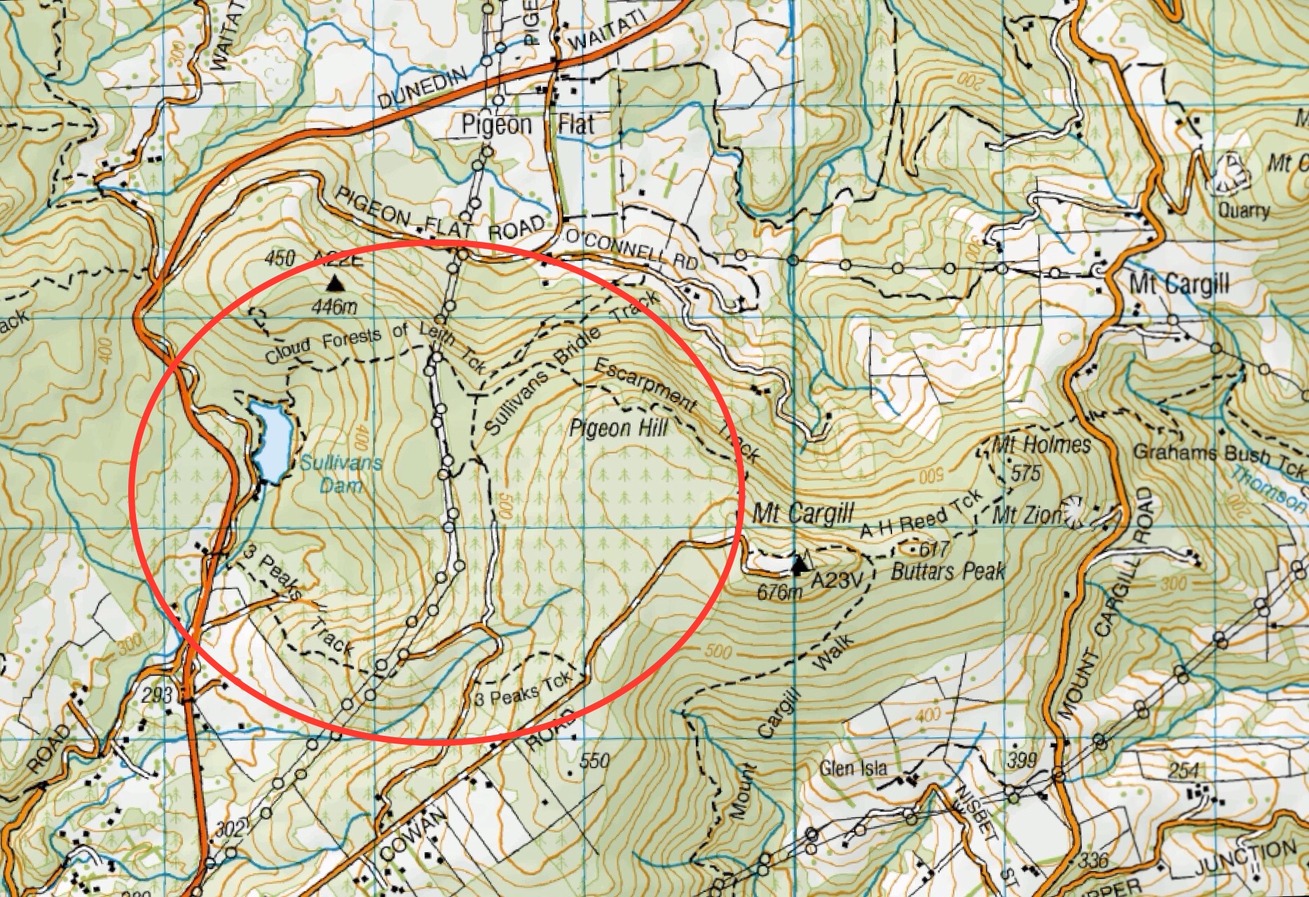
This page of club tramps and hikes in the Dunedin Central City area groups together trips to Mt Cargill via Cowan Road, Sullivans Dam, Cloud Forest Track, 3 Peaks Track, Escarpment Track. (map)
Road distances from Mosgiel carpark.
Map: Sullivans Dam, Cloud Forest, Telegraph (Old Bridal) track to Pigeon Flat, Escarpment Track, Cowan Rd, Short Cut to Fox Rd, down to Sullivans Dam – drawn 2002. – click on Sullivans Dam, Cloud Forests, Escarpment, Cowan round trip link below.
Pine Hill, Mount Cargill round trip. 2023 -1991 (4 trips, 1 with report and photos – 23/9/2023)
Sullivans Dam, Cloud Forests, Escarpment, Cowan round trip. 2022-2005 (10 trips, 5 with reports and photos, 2 with photos only, 5 with no report or photos)
Sullivans Dam. 2009 – 1998 (7 trips – no reports or photos)
Leith Saddle, Sullivans Dam, Bridle Track, Pigeon Flat. 2006 – 1999 (4 trips – no reports or photos)
This page of club tramps and hikes in the Dunedin Central City area groups together trips Town Belt and includes Bellknowes, Bullock Track, Cosy Dell, Olveston, Robin Hood Park, Unity Park.
Road distances from Mosgiel carpark.
There is a heap of info on Google if any one wants to find out about the town belt, Olveston, and any of the grounds like Robin Hood. Also the Dunedin Amenities Soc. have a wonderful web page as well.
Street Walk: Town Belt areas. 2024 – 2008 (11 trips with reports and photos)
This page of club tramps and hikes in the Dunedin Central City area groups together trips incorporating Roslyn, Mornington, Wakari, Highgate, Kaikorai and surrounds.
Road distances from Mosgiel carpark.
25/09/2024. Wakari / Kaikorai Loop. Hikers Leaders: Jenny Finnerty and Ady Whitson
Street Walk: Roslyn and Kaikorai. 2023 – 1998 (3 trips, 1 with report and photos)
Mornington Ramble. 2023 – 2008 (7 trips, with reports, 6 with photos)
Mornington – Southern Cemetery. 2008 (1 trip with report)
Street Walk: Wakari. 2008 (1 trip with report and photos)
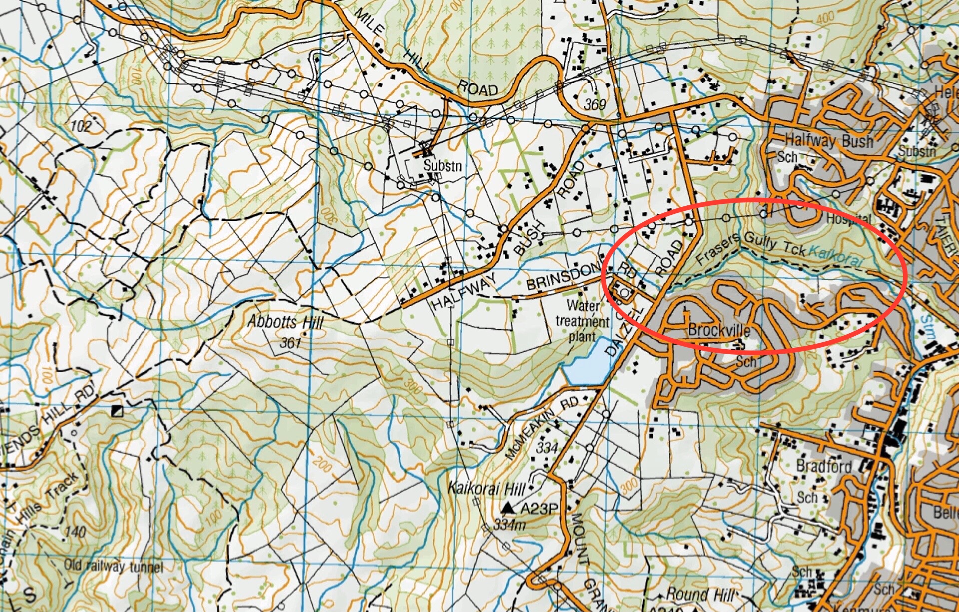
This page of club tramps and hikes in the Central City area groups together trips from Frasers Gully Reserve, incorporating Friends Hill to Wingatui Racecourse including the Wingatui Tunnel. (map)
Road distances from Mosgiel carpark.
TRTC Grading Information – trips incorporating these tracks are generally given a TRTC grading of about 3. This is indicative only, as trips can be allocated a higher or lesser grading depending on the route taken. For more detailed analysis refer to Grading Information.
Frasers Gully track is located at the end of Frasers Road off Kaikorai Valley Road. Carparking is available by the Roslyn Wakari Football club rooms at the start of the track.
18/06/2025. Frasers Gully – Friends Hill. Grade 3.5. Hikers. Leaders: Janette Abbott and Maria MacNee.
20/11/2024. Frasers Gully / Friends Hill / Wingatui Tunnel & Return. Grade 3.5. Trampers. Leaders: Anne Ward and Lyn Keene.
09/10/2024. Fraser’s Gully. Grade 2.5. Hikers. Leaders Helen Morris and Heather Reid.
Frasers Gully. 2024 – 1989 (32 trips with 11 reports, 1 with photos only and 20 with no reports)
This grouping of Club tramps and hikes covers trips in the Central City and involves the Botanic Garden (both upper and lower), Chingford park, University walkways, Willowbank, and the Woodhaugh Gardens.
Road distances from Mosgiel carpark.
28/08/2024. Botanic Garden, Chingford Park. Hikers. Grade 3. Leaders :Dave Roberts, Vivienne Manning
Chingford Park, Quarry. 2021 – 2007, 6 trips with 5 reports
Street Walk – Willowbank-Opoho area. 2022 – 2017, 2 trips with reports
Botanic Garden, Logan Park, Northern Cemetery, Chingford, Big Easy 2021 – 1996, 25 trips with 16 reports inc. 15/05/2019 and 19/11/2008 for Chingford.
Waters of the Leith. 2022 – 2023 – 2022, 2 trips with reports
Woodhaugh Gardens and Leith. 2020 – 1996, 10 trips with 5 reports
Road distances from Mosgiel carpark.
See also Tunnel Beach – Information and Trips Archive for Tunnel Beach trips starting at Concord.
17/07/2024. Concord Creations. Hikers. Leaders: Jan Butcher. & Jenny Finnerty.
Concord Blackhead (1989 – 2015 (4 trips with only 1 report)).
Road distances from Mosgiel carpark.
Ocean Grove, also known as Tomahawk, is a suburb in the southeast of the city of Dunedin. … The suburb was known as Tomahawk until the 1930s, the name not being a reference to the weapon, but rather possibly an anglicised form of the Māori words tomo haka, meaning “dance by a gravesite”.
26/03/2025. St Kilda / Tomahawk Beach. Grade 1.5 Hikers. Leaders: Wendy Langley and Val Cayford.
07/08/2024. City to Surf. Combined. Leaders: Gail Williams, Karen McInnes, Jenni and Bruce Wright.
24/07/2024. Delights of St Clair. Hikers. Leaders: Neville Griffiths, Wyn Davies.
St Clair Beach Walks (1995 – 2023, 17 trips).
Street Walk: St Clair – Kew (2000 – 2022, 2 trips – 1 report).
Tomahawk Lagoon and Nearby Tracks and Areas (1989 – 2023, 43 trips, 19 reports; see 40, 38, 36, 35, 33, 29 and 26.)
Road distances from Mosgiel carpark.
Street Art Trail A3 Map (2016 – not up to date)
Dunedin Street Art Map (no details other than artist name and location).
21/08/2024 . Street Art Walk. Trampers Leaders: Wendy Langley,Val Cayford.
10/07/2024. Street Art Trail and Surrounds. Hikers. Leaders: Wendy Langley, Val Cayford.
Midwinter Street Walk – Street Art (2015 – 2021)
Follow the Leith (2022 – 2023) University campus.