Scope:
This page of club tramps and hikes in the South Coast area groups together trips to Kaitangata and Inch Clutha (map)
Background Information:
Road distances from Mosgiel carpark.
TRTC Grading Information – trips incorporating these tracks are generally given a TRTC grading of about 2. This is indicative only, as trips can be allocated a higher or lesser grading depending on the route taken. For more detailed analysis refer to Grading Information.
How To Get There:
Take SH1 south to the Kaitangata turn off (well sign posted) and turn left onto the road taking your to Kaitangata township. Take Clyde Terrace along side the river and cross the bridge onto Riverside Road. Continue on this road and turn left onto Telegraph Road. Turn left onto Centre Road and continue to small car park by boat ramp to the Clutha River.
Links to tramps and hikes in this area:
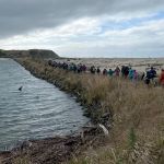
02/04/2025. Inch Clutha. Grade 2.5. Combined. Leaders: Phil Keene, Graeme Souter, Bruce & Jenny Wright.
Kaitangata. 2003 – 1992 (3 trips. 1 trip (14/9/2023) as guests of Trixie Trampers (Blaclutha) with report and photos)

 02/04/2025. Inch Clutha. Grade 2.5. Combined. Leaders: Phil Keene, Graeme Souter, Bruce & Jenny Wright.