Click on Map to Enlarge
Taieri Recreational Tramping Club
Mid-week recreational and social walking group based in Mosgiel NZ

Click on Map to Enlarge
This page of club tramps and hikes in the Silver Peaks area groups together trips to the South Branch of the Waikouati River
Road distances from Mosgiel carpark.
TRTC Grading Information – trips to the South Waikouaiti River track are generally given a TRTC grading of 4. This is indicative only, as depending on the route taken, allocation of gradings can differ from this. For more detailed analysis refer to Grading Information.
Mountain Road / South Waikouaiti River. 2024 – 2021 (2 trips, both with reports and photos)
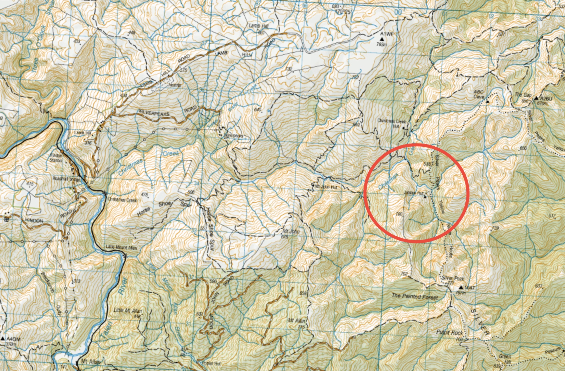
This page of club tramps and hikes in the Silver Peaks area groups together trips to Jubilee Hut (incorporates Christmas Creek, Silverpeaks Station, Lamb Hill, Mt John). (map)
Road distances from Mosgiel carpark.
TRTC Grading Information – trips to Jubilee Hut are generally given a TRTC grading of 5. This is indicative only, as depending on the route taken, allocation of gradings can differ from this. For more detailed analysis refer to Grading Information.
Access Permissions are required as this trip ventures over a working farm – refer guidelines
Jubilee Hut is located in the Silverpeaks areas and can be accessed by numerous tracks. TRTC preferred access is via Hindon via Silverpeaks Station and Christmas Creek.
Taking George King Memorial Drive (turn right after crossing the bridge over the Taieri River just out of Outram) and follow the road past Lee Stream. Turn right onto Hindon Road which descends to the Hindon Railway Station. Cross the Taieri River (via rail/road bridge) and take to Silverpaeaks Station and parking.
Silverpeaks Station to Jubilee, Orange & Mount John Huts. 2020 – 1999 (7 trips, 5 with reports and photos, 1 with photos only, 1 with no report or photos)
Click on map to enlarge
See also TRTC LINKS PAGE – Silverpeaks Tracks
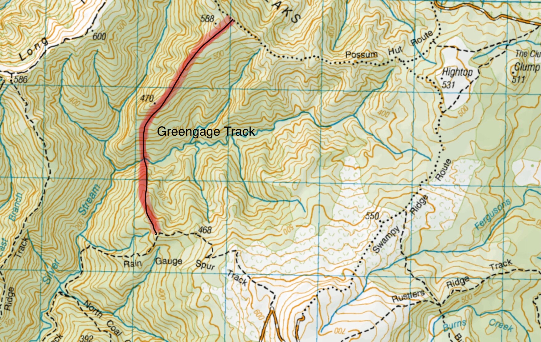
Greengage track is not shown on any NZ Topo maps. This image gives an approximation of the track route.
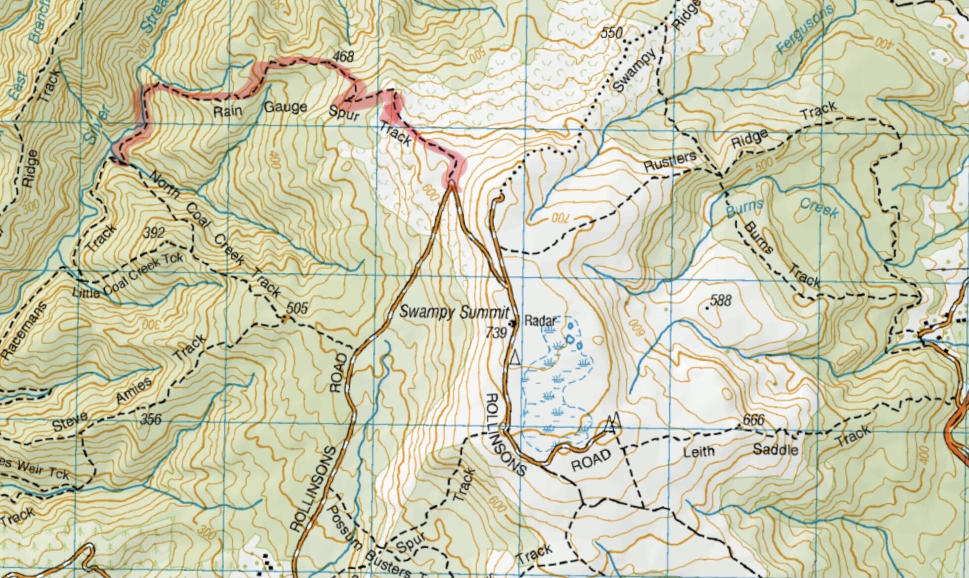
This page of club tramps and hikes in the Silver Peaks area groups together those trips to the Greengage Track (map) which incorporates Raingauge Spur, Swampy Ridge, Rollinsons and Green Ridge Tracks.
Road distances from Mosgiel carpark.
The Greengage Track runs between Raingauge Spur and the Green Ridge Track. There is a number of ways to access this track – the following provides 3 options.
Option 1 – via Raingauge Spur which is via Rollinsons Road and will require a key to the gate approx. 2 km’s from the “Elbow” where the Raingauge track starts. A key is currently held by the club President.
Option 2 – via the Swampy Ridge Track. Access to the summit of Swampy is via Rollisons Road (option 1) with the track commencing from the Swampy Summit. This route joins the Green Ridge which forks with Greengage.
Option 3 – via Waitati. Turn left onto Double Hill Road which joins Semple Road to the starting point of he Green Ridge Track.
30/10/2024. Greengage Track. Trampers. Leaders: Graeme Souter and Graham Thurlow.
Greengage Track. 2019-2014 (3 trips with reports and photos)
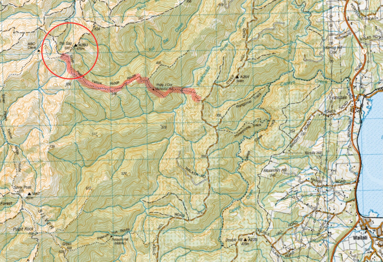
This page of club tramps and hikes in the Silver Peaks area groups together trips to Yellow Ridge (map) including Gap Ridge, The Gap, Yellow Hut and the South Branch of the Waikouati River
Road distances from Mosgiel carpark.
TRTC Grading Information – trips to Yellow Ridge, The Gap etc are generally given a TRTC grading of 5. This is indicative only, as depending on the route taken, allocation of gradings can differ from this. For more detailed analysis refer to Grading Information.
Silver Peaks Forest for background information on the area.
Accessed from Mountain Road from old forest HQ 6 hr ret, Route, DOC and private land.
Proceed via the Northern motorway to Waitati and turn left onto Double Hill Road (just past the store on the left at the end of the motorway), which joins Steep Hill Road. Access to Yellow Ridge route is located off this road.
19/03/2025. Yellow Ridge via Walkers Road, River Track/out via Tunnel Track. Grade 5. Trampers. Leader: Ross Davies.
Tunnels Track, Yellow Hut, The Gap, Gap Ridge. 2021 -1997 (8 trips, 6 with reports and photos, 2 with no reports)
This page of club tramps and hikes in the Silver Peaks area groups together trips to Rosella Ridge.
Road distances from Mosgiel carpark.
Rosella Ridge. 2024 – 1992 (9 trips, 8 with reports and photos)
This page of club tramps and hikes in the Silver Peaks area groups together those trips on the Raingauge Spur. (map)
Road distances from Mosgiel carpark.
Access to the Raingauge Spur can be made via Rollinsons Road which will require a key to the gate approx. 2 km’s from the “Elbow” where the track starts. A key is currently held by the clubs President.
18/09/2024 Raingauge Ridge – Steve Amies. Grade 4.5. Trampers. Leaders: Neil Hodgkin and Sarah McCormack.
Rain Gauge Spur via Picnic area, Nth Coal, Racemans. 2009 – 1998 (8 trips, 1 with a report, 1 with photos only, 6 with no reports / photos)
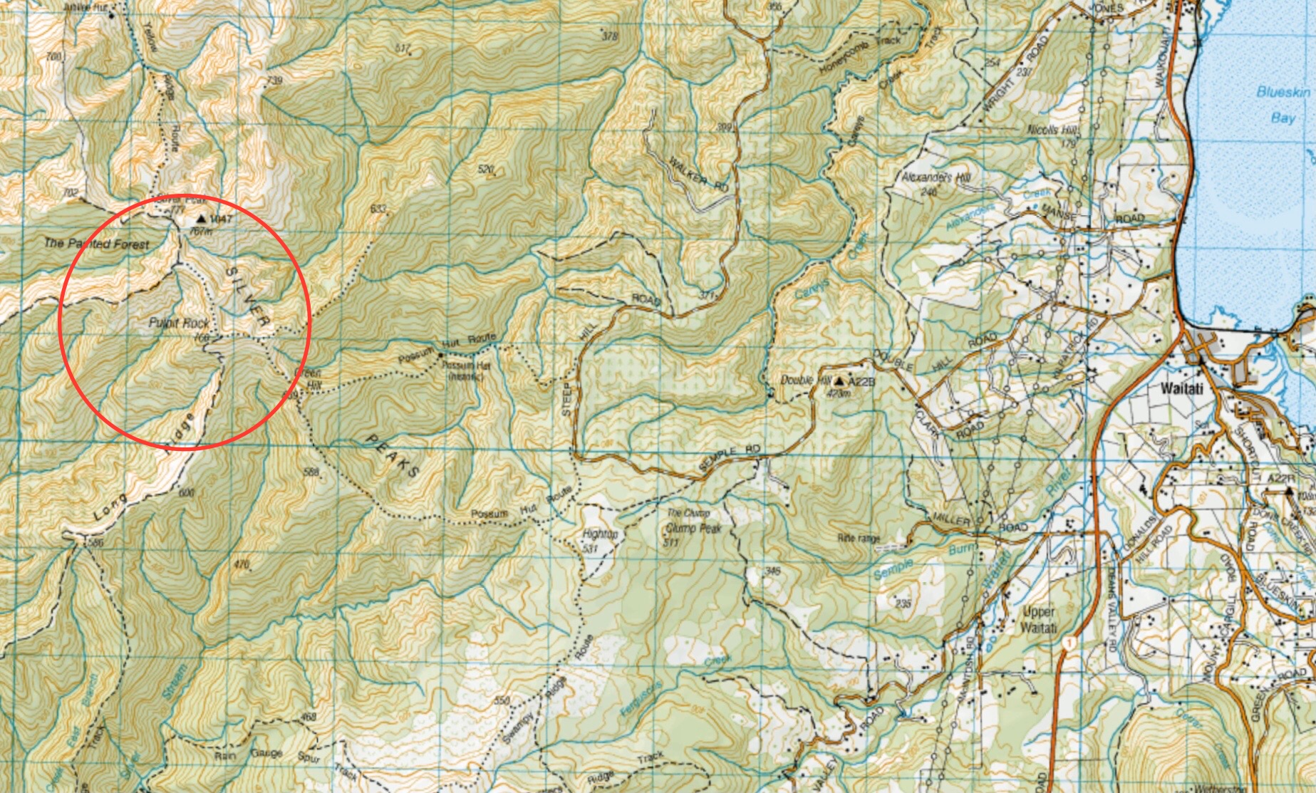
This page of club tramps and hikes in the Silver Peaks area groups together trips to Pulpit Rock. (map)
Road distances from Mosgiel carpark.
TRTC Grading Information – trips incorporating these tracks are generally given a TRTC grading of about 4. This is indicative only, as trips can be allocated a higher or lesser grading depending on the route taken. For more detailed analysis refer to Grading Information.
Silver Peaks Forest for background information.
There are any number of tracks within the Silver Peaks that will reach Pulpit Rock. Arguably the most common way is via the Possum Hut track.
Proceed via the Northern motorway to Waitati and turn left onto Double Hill Road (just past the store on the left at the end of the motorway), which joins Semple Road where there is several access points to the Possum Hut track.
14/05/2025. Pulpit Rock. Grade 4. Trampers. Leaders: Graham Thurlow, Lyn Keene.
Green Hut, Pulpit Rock. 2023 – 1988 (10 trips with reports and photos, 13 with no reports).
Shuttle: Mountain Road, Pulpit Rock, Long/Powder Ridges, Whare Flat. 2019 – 1998 (3 trips with 1 report and photos, 2 trips with no reports)